Eaubonne
| Eaubonne | ||
|---|---|---|
|
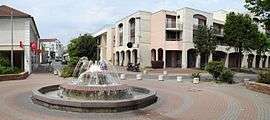
The Avenue de l'Europe, in Eaubonne | ||
| ||
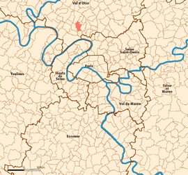 Location (in red) within Paris inner and outer suburbs | ||
| Coordinates: 48°59′32″N 2°16′50″E / 48.9922°N 2.2806°ECoordinates: 48°59′32″N 2°16′50″E / 48.9922°N 2.2806°E | ||
| Country | France | |
| Region | Île-de-France | |
| Department | Val-d'Oise | |
| Arrondissement | Pontoise | |
| Canton | Ermont | |
| Intercommunality | Val Parisis | |
| Government | ||
| • Mayor (2014–2020) | Grégoire Dublineau | |
| Area1 | 4.42 km2 (1.71 sq mi) | |
| Population (2013)2 | 24,606 | |
| • Density | 5,600/km2 (14,000/sq mi) | |
| Time zone | CET (UTC+1) | |
| • Summer (DST) | CEST (UTC+2) | |
| INSEE/Postal code | 95203 / 95600 | |
| Elevation | 41–83 m (135–272 ft) | |
|
1 French Land Register data, which excludes lakes, ponds, glaciers > 1 km² (0.386 sq mi or 247 acres) and river estuaries. 2 Population without double counting: residents of multiple communes (e.g., students and military personnel) only counted once. | ||
.svg.png)
Eaubonne (IPA: [obɔn]) is a commune in the northern suburbs of Paris, France. It is located 16.1 km (10.0 mi) from the center of Paris.
Twin towns
It is twinned with Matlock, Derbyshire, England and Budenheim, Germany.
Transport
Eaubonne is served by Ermont – Eaubonne station which is an interchange station on Paris RER line C, on the Transilien Paris – Nord suburban rail line, and on the Transilien Paris – Saint-Lazare suburban rail line. This station is located at the border between the commune of Eaubonne and the commune of Ermont, on the Ermont side of the border.
Eaubonne is also served by Champ de Courses d'Enghien station on the Transilien Paris – Nord suburban rail line. This station is located at the border between the commune of Eaubonne and the commune of Soisy-sous-Montmorency, on the Soisy-sous-Montmorency side of the border.
See also
References
External links
| Wikimedia Commons has media related to Eaubonne. |
- Official website (French)
- Mérimée database - Cultural heritage (French)
- Land use (IAURIF) (English)