Edworthy Park
| Edworthy Park | |
|---|---|
|
Bow River seen from Edworthy Park | |
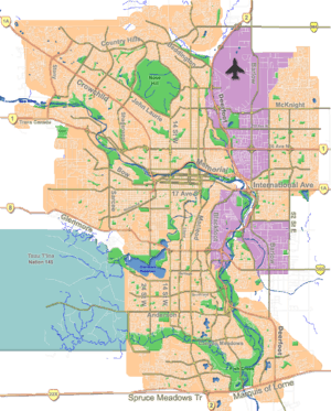
 Location of Edworthy Park in Calgary | |
| Type | Urban park |
| Location | Calgary, Alberta |
| Coordinates | 51°03′41″N 114°09′23″W / 51.06139°N 114.15639°W |
| Area | 1.27 square kilometres (0.49 sq mi) |
| Created | 1995? |
| Operated by | City of Calgary |
| Open | Year round |
Edworthy Park is a city park located in the Northwest section of Calgary along the south shore of the Bow River. The Canadian Pacific Railway crosses the length of the park. It was named after Thomas Edworthy, who emigrated to the Calgary area in 1883 from Devon, England.[1]
The park has a surface of 1.27 square kilometres (0.49 sq mi), and contains over 5 kilometres (3.1 mi) of hiking and biking trails, part of the Bow River pathway.
Nature
The trees that can be found in Edworthy Park include riparian woodland with aspen, willow and balsam poplar. There is also some grassland and mixed shrubland, and an escarpment where white spruce dominates. Within the spruce is an isolated population of Douglas-fir, some more than 400 years old.
Freeway plans
Prior to the mid-1990s, the City of Calgary had always intended Edworthy Park to be a temporary park, which would eventually be replaced by an extension of the Shaganappi Trail freeway which would hook up with Sarcee Trail and Bow Trail at a major interchange that would take up most of the park's southwest. During development of the Calgary Transportation Plan (a.k.a. The Go Plan) in 1995, public opposition to the roadway led to it being removed from future consideration.[2]
Gallery
-
Harry Boothman Bridge from Edworthy Park to Shaganappi
References
- ↑ The Edworthy Park Heritage Society (1994). Early Days in Edworthy Park and the Neighboring areas of Brickburn and Lowery Gardens. Calgary. p. 9.
- ↑ City of Calgary (2005). "Calgary Transportation Plan 2005". Archived from the original on 2007-06-19. Retrieved 2007-07-04.
