Fish Creek Provincial Park
| Fish Creek Provincial Park | |
|---|---|
|
Fish Creek Park | |
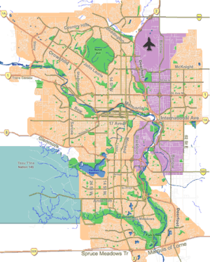 Location of Fish Creek Provincial Park in Calgary | |
| Location |
|
| Nearest city |
|
| Coordinates | 50°55′18″N 114°03′30″W / 50.9217°N 114.0583°WCoordinates: 50°55′18″N 114°03′30″W / 50.9217°N 114.0583°W |
| Area | 13.48 km2 (5.20 sq mi) |
| Established | June 10, 1975 |
| Governing body | Alberta Tourism, Parks and Recreation |
Fish Creek Park is a provincial park located in the southern part of Calgary, Alberta, Canada. It is the second largest urban park in Canada after Pippy Park in St. John's and one of the largest urban parks in North America, stretching 19 km (12 mi) from east to west. At 13.48 km2 (5.20 sq mi), it is over three times the size of Vancouver's Stanley Park.
The growth of Calgary has left the park bordered on all sides by the city. It is also bordered on the west by the territory of the Tsuu T’ina Nation (Sarcee), a First Nation.
Fish Creek flows along the length of the park and joins the Bow River at the east side of the park. Fish Creek park used to span the width of the city but Calgary has grown beyond the edges of the park.
Amenities
A variety of paved and unpaved walking, hiking and bicycle trails connect the park to the city's extensive trail system allowing visitors to access on-site day-camping facilities, stables, and an artificial lake, which allows swimming.[1] The park features 80 kilometres (50 mi) of trails, of which 30 kilometres (19 mi) are paved,[2] and is home to a large variety of natural wildlife, including deer, coyotes, owls, and beavers. Over 200 bird species have been seen in the park include great blue herons.
The park features several picnicking and forest areas. The most widely used section of the park is the beach at Sikome Lake where thousands of Calgarians swim every summer weekend. The lake is man-made and is drained during the winter months. At the east end of the park there is a Visitor Center, an Artisan Garden, Bow Valley Ranche restaurant, which offers fine dining year-round for corporate and private functions, Annie's Bakery and Cafe that offers coffee, soups, sandwiches and pastries during the summer and the office of Friends of Fish Creek, a volunteer society that does trail maintenance and sponsors events in the park. Across the park from this site there are several shallow caves carved by springs in the valley wall.
There is no admission fee to enter the different areas of the park.
Contemporary issues

As a result of the heavy rains and floods experienced by Alberta in June 2005, half of the park's trails were washed away, and the other half damaged.[3] Seven pedestrian bridges over the Fish Creek were destroyed and seven others were rendered unsafe. The park officially reopened in September 2007 following the construction of new bridges and a redesigned pathway system.
The park's location and city growth in the south poses problems for city planners. Limited points exist to build roadways across the park. Three arteries (Deerfoot Trail/Highway 22X, Macleod Trail and 37th Street SW), plus a C-Train rapid transit line, exist to connect the southern portions of the city with the north. This results in frequent rush hour traffic delays as the traffic bottle necks. A long-proposed southwest extension of Sarcee Trail (roughly following the 37th Street alignment) is expected to alleviate these bottlenecks, as is the 2013 completion of the southeastern leg of the Stoney Trail freeway.
The park's trails and facilities see three million visitors a year and are patrolled by Conservation Officers designated under the Ministry of Tourism Parks and Recreation.
See also
References
- ↑ Fish Creek Park information
- ↑ Alberta Tourism, Parks, Recreation & Culture. "Activities in Fish Creek Provincial Park". Retrieved 2007-07-15.
- ↑ "Deluge leaves Alberta park devastated". CBC News. June 22, 2005. Retrieved September 24, 2011.
| Landmarks | |
|---|---|
| Attractions | |
| Venues | |
| Parks | |
| Malls | |
| Recreation | |