Egremont, Mississippi
| Egremont | |
|---|---|
| Unincorporated community | |
 Egremont  Egremont | |
| Coordinates: 32°51′38″N 90°54′12″W / 32.86056°N 90.90333°WCoordinates: 32°51′38″N 90°54′12″W / 32.86056°N 90.90333°W | |
| Country | United States |
| State | Mississippi |
| County | Sharkey |
| Elevation | 105 ft (32 m) |
| Time zone | Central (CST) (UTC-6) |
| • Summer (DST) | CDT (UTC-5) |
| GNIS feature ID | 669697[1] |
Egremont is an unincorporated community in Sharkey County, Mississippi, United States. A variant name for the community is "Baconia".[1]
Egremont is located on U.S. Route 61, 4 miles (6.4 km) south of Rolling Fork.
History
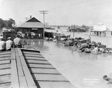
During the American Civil War of 1861-1865, a military campaign launched by Union forces was slowed by obstructions placed along Deer Creek at the Egremont Plantation.[2]
In 1880, the Egremont Plantation became the property of Hezekiah William Foote. It was inherited by his son Huger Lee Foote, who was elected Sheriff of Sharkey County in 1890, and went on to serve in the Mississippi Legislature.[3]
In 1984, sculptor Wesley Bobo erected a steel dinosaur along Route 61 in Egremont.[4]
A local juke joint called "Willie Mama's" was located in Egremont, but closed in 2007. It re-opened under the name "The Waterin Hole".
References
- 1 2 "Egremont". Geographic Names Information System. United States Geological Survey.
- ↑ Dumas, David (2012). Steele's Bayou Expedition, a Driving Tour Guide. Author House.
- ↑ Woods, Woody (2010). Delta Plantations - the Beginning. Troy (Woody) Woods. pp. 40, 42.
- ↑ Black, Patti Carr (1988). Art in Mississippi, 1720-1980. University Press of Mississippi. p. 150.
External links
Municipalities and communities of Sharkey County, Mississippi, United States | ||
|---|---|---|
| City | 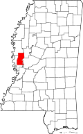 | |
| Towns | ||
| Unincorporated communities | ||