Egvekinot
| Egvekinot (English) Эгвекинот (Russian) Ирвыкыннот (Chukchi) | |
|---|---|
| - Urban-type settlement[1] - | |
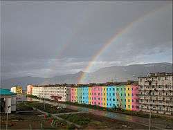 Double rainbow over Egvekinot | |
.svg.png) Location of Chukotka Autonomous Okrug in Russia | |
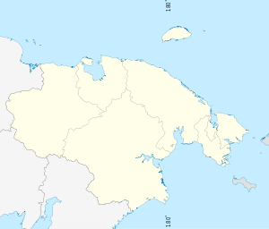 Egvekinot | |
|
| |
| Administrative status (as of June 2012) | |
| Country | Russia |
| Federal subject | Chukotka Autonomous Okrug[1] |
| Administrative district | Iultinsky District[1] |
| Administrative center of | Iultinsky District[1] |
| Municipal status (as of October 2010) | |
| Municipal district | Iultinsky Municipal District[2] |
| Urban settlement | Egvekinot Urban Settlement[2] |
| Administrative center of | Iultinsky Municipal District,[2] Egvekinot Urban settlement[2] |
| Head | Alexey Geraskin |
| Statistics | |
| Population (2010 Census) | 2,790 inhabitants[3] |
| Population (January 2016 est.) | 2,815 inhabitants[4] |
| Time zone | PETT (UTC+12:00)[5] |
| Founded | 1946[6] |
| Postal code(s)[7] | 689201, 689202 |
| Dialing code(s) | +7 42734 |
Egvekinot (Russian: Эгвекино́т; Chukchi: Ирвыкыннот, lit. sharp, hard land)[6] is an urban locality (an urban-type settlement) and the administrative center of Iultinsky District in Chukotka Autonomous Okrug, Russia. Population: 2,790 (2010 Census);[3] 2,413 (2002 Census);[8] 5,478 (1989 Census).[9]
Geography
Egvekinot, located on the coast of Kresta Bay (a part of the Bering Sea) at the foot of mountains some 800 meters (2,600 ft) high, is a port settlement with a maximum depth of 35 meters (115 ft).[10] It is located 1,675 kilometers (1,041 mi) from Magadan, 236 kilometers (147 mi) from Anadyr, and 6,097 kilometers (3,789 mi) from Moscow.[10]
History
Archeological excavations around the settlement have indicated that the area was inhabited in Neolithic times and possibly even in the Mesolithic, with the discovery of a number of stone implements, tools for grinding and obsidian arrowheads, all of which are now stored in the local museum in Egvekinot.[10]
In 1937, metal deposits were discovered in Iultin.[10] Due to the isolated nature of the area, the transportation of any minerals extracted would be difficult and it was decided that a new port would be created to serve the Iultin mines.[10] Dalstroy formed a new section, "Chukotstroy", whose aim was to construct Egvekinot and the road connecting it with the Iultin mines.[10]
Egvekinot was founded in 1946,[6] under the supervision of B. N. Lenkov, the first head of Chukotstroy, specifically as a port so that the nearby Iultin Mining Complex about 180 kilometers (110 mi) north of the settlement could be easily supplied with materials. On July 16, 1946, the MV Sovetskaya Latviya brought the first 1,500 settlers to Egvekinot.[10] These construction workers were mainly political prisoners rather than willing emigrants. This labor force was responsible for the construction of the entire infrastructure in the area, including the construction of Egvekinot, the nearby village of Ozyorny, and the village of Iultin, as well as the 270-kilometer (170 mi) road linking the mines to the new port, the power station, warehouses, and residential and industrial buildings.[10]
As a result of this, the settlement became quite an important hub causing the population to grow to over 5,000 by the late 1980s. However, when the mining complex was closed in 1993, the economy of Egvekinot suffered with the population falling rapidly throughout the 1990s, although the 2010 Census details indicate a slight recovery in recent years.
Administrative and municipal status
Within the framework of administrative divisions, Egvekinot serves as the administrative center of Iultinsky District, to which it is directly subordinated.[1] As a municipal division, the urban-type settlement of Egvekinot is incorporated within Iultinsky Municipal District as Egvekinot Urban Settlement.[2]
The nearby former selo of Ozyorny has been incorporated into Egvekinot as Ozyorny Microdistrict.
Transportation
Egvekinot can be reached by flights from Anadyr (236 kilometers (147 mi)) which land at the Kresta Bay Airport, though the spring meltwaters can cause the runway to become flooded. Infrequent helicopter service to Provideniya by Chukotavia.
Egvekinot is linked to the now abandoned settlement of Iultin by the Iultin-Egvekinot road (around 200 kilometers (120 mi)) via Amguema, as well as to the abandoned settlements of Dorozhny, Tranzitny, and Geologichesky. The road crosses the Amguema River.
Demographics
| 1959 Census | 1970 Census | 1979 Census | 1989 Census | 2002 Census | 2010 Census |
|---|---|---|---|---|---|
| 3,015 | 3,360[11] | 4,657[12] | 5,478[13] | 2,413[14] | 2,790[3] |
Culture and sights
A monument to the MI-8 helicopter, a common sight in the air over Chukotka, is located in the airport.
There is a museum in the settlement which deals mainly with local history, people, and archeology, as well as a cultural center, home to the Zalivskiye Napevy folk chorus, the Sone song group, and Severyanka folk dance ensemble.[6]
Egvekinot has one of only two ski slopes in Chukotka; a ski lodge can be found near the Staratelsky Stream.
Climate
Egvekinot has a polar climate (Köppen ET). Temperatures can be below freezing from October all the way through to the following May, and below −20 °C (−4 °F) from December through to March. The short summer is temperate.
| Climate data for Egvekinot | |||||||||||||
|---|---|---|---|---|---|---|---|---|---|---|---|---|---|
| Month | Jan | Feb | Mar | Apr | May | Jun | Jul | Aug | Sep | Oct | Nov | Dec | Year |
| Record high °C (°F) | 6.3 (43.3) |
7.0 (44.6) |
6.1 (43) |
10.0 (50) |
20.0 (68) |
28.9 (84) |
27.8 (82) |
25.0 (77) |
20.6 (69.1) |
11.0 (51.8) |
7.8 (46) |
7.2 (45) |
28.9 (84) |
| Average high °C (°F) | −14.6 (5.7) |
−14.9 (5.2) |
−12.8 (9) |
−7.9 (17.8) |
1.8 (35.2) |
9.8 (49.6) |
13.0 (55.4) |
12.1 (53.8) |
6.7 (44.1) |
−2.1 (28.2) |
−8.8 (16.2) |
−13.3 (8.1) |
−2.8 (27) |
| Daily mean °C (°F) | −18.2 (−0.8) |
−18.7 (−1.7) |
−16.8 (1.8) |
−11.6 (11.1) |
−1.2 (29.8) |
6.0 (42.8) |
9.9 (49.8) |
9.2 (48.6) |
4.1 (39.4) |
−4.6 (23.7) |
−11.7 (10.9) |
−16.6 (2.1) |
−6.1 (21) |
| Average low °C (°F) | −21.5 (−6.7) |
−22.4 (−8.3) |
−20.8 (−5.4) |
−15.8 (3.6) |
−4.2 (24.4) |
2.7 (36.9) |
7.1 (44.8) |
6.6 (43.9) |
1.5 (34.7) |
−7 (19) |
−14.4 (6.1) |
−19.7 (−3.5) |
−9.3 (15.3) |
| Record low °C (°F) | −47.2 (−53) |
−46.7 (−52.1) |
−43.9 (−47) |
−37.8 (−36) |
−30 (−22) |
−10 (14) |
−6.2 (20.8) |
−6 (21) |
−10 (14) |
−27.8 (−18) |
−41.1 (−42) |
−48 (−54) |
−48 (−54) |
| Average precipitation mm (inches) | 36.0 (1.417) |
34.6 (1.362) |
63.9 (2.516) |
32.6 (1.283) |
31.7 (1.248) |
58.4 (2.299) |
101.3 (3.988) |
107.8 (4.244) |
58.2 (2.291) |
45.8 (1.803) |
59.4 (2.339) |
45.3 (1.783) |
675.0 (26.575) |
| Average precipitation days | 12.3 | 12.3 | 11.8 | 13.2 | 15.6 | 14.6 | 15.9 | 17.3 | 13.1 | 16.1 | 14.4 | 14.4 | 171 |
| Average relative humidity (%) | 71.2 | 71.4 | 72.8 | 74.3 | 79.4 | 80.1 | 79.6 | 80.9 | 76.0 | 70.5 | 69.2 | 69.0 | 74.5 |
| Source: climatebase.ru (1948–2011)[15] | |||||||||||||
See also
References
Notes
- 1 2 3 4 5 Directive #517-rp
- 1 2 3 4 5 Law #149-OZ
- 1 2 3 Russian Federal State Statistics Service (2011). "Всероссийская перепись населения 2010 года. Том 1" [2010 All-Russian Population Census, vol. 1]. Всероссийская перепись населения 2010 года (2010 All-Russia Population Census) (in Russian). Federal State Statistics Service. Retrieved June 29, 2012.
- ↑ Chukotka Autonomous Okrug Territorial Branch of the Federal State Statistics Service. Численность постоянного населения Чукотского автономного округа по муниципальным образованиям на 1 января 2016 года (Russian)
- ↑ Правительство Российской Федерации. Федеральный закон №107-ФЗ от 3 июня 2011 г. «Об исчислении времени», в ред. Федерального закона №271-ФЗ от 03 июля 2016 г. «О внесении изменений в Федеральный закон "Об исчислении времени"». Вступил в силу по истечении шестидесяти дней после дня официального опубликования (6 августа 2011 г.). Опубликован: "Российская газета", №120, 6 июня 2011 г. (Government of the Russian Federation. Federal Law #107-FZ of June 31, 2011 On Calculating Time, as amended by the Federal Law #271-FZ of July 03, 2016 On Amending Federal Law "On Calculating Time". Effective as of after sixty days following the day of the official publication.).
- 1 2 3 4 Fute, p. 125
- ↑ Почта России. Информационно-вычислительный центр ОАСУ РПО. (Russian Post). Поиск объектов почтовой связи (Postal Objects Search) (Russian)
- ↑ Russian Federal State Statistics Service (May 21, 2004). "Численность населения России, субъектов Российской Федерации в составе федеральных округов, районов, городских поселений, сельских населённых пунктов – районных центров и сельских населённых пунктов с населением 3 тысячи и более человек" [Population of Russia, Its Federal Districts, Federal Subjects, Districts, Urban Localities, Rural Localities—Administrative Centers, and Rural Localities with Population of Over 3,000] (XLS). Всероссийская перепись населения 2002 года [All-Russia Population Census of 2002] (in Russian). Retrieved August 9, 2014.
- ↑ Demoscope Weekly (1989). "Всесоюзная перепись населения 1989 г. Численность наличного населения союзных и автономных республик, автономных областей и округов, краёв, областей, районов, городских поселений и сёл-райцентров" [All Union Population Census of 1989: Present Population of Union and Autonomous Republics, Autonomous Oblasts and Okrugs, Krais, Oblasts, Districts, Urban Settlements, and Villages Serving as District Administrative Centers]. Всесоюзная перепись населения 1989 года [All-Union Population Census of 1989] (in Russian). Институт демографии Национального исследовательского университета: Высшая школа экономики [Institute of Demography at the National Research University: Higher School of Economics]. Retrieved August 9, 2014.
- 1 2 3 4 5 6 7 8 Alexander Spiridonov. Egvekinot-1996 (Russian)
- ↑ Перепись населения СССР 1970 года 1970 Census of the Soviet Union Archived March 23, 2012, at the Wayback Machine.
- ↑ "Всесоюзная перепись населения 1979 г. Национальный состав населения по регионам России. (All Union Population Census of 1979. Ethnic composition of the population by regions of Russia.)". Всесоюзная перепись населения 1979 года (All-Union Population Census of 1979) (in Russian). Demoscope Weekly (website of the Institute of Demographics of the State University—Higher School of Economics. 1979. Retrieved 2008-11-25.
- ↑ Demoscope Weekly (1989). "Всесоюзная перепись населения 1989 г. Численность наличного населения союзных и автономных республик, автономных областей и округов, краёв, областей, районов, городских поселений и сёл-райцентров" [All Union Population Census of 1989: Present Population of Union and Autonomous Republics, Autonomous Oblasts and Okrugs, Krais, Oblasts, Districts, Urban Settlements, and Villages Serving as District Administrative Centers]. Всесоюзная перепись населения 1989 года [All-Union Population Census of 1989] (in Russian). Институт демографии Национального исследовательского университета: Высшая школа экономики [Institute of Demography at the National Research University: Higher School of Economics]. Retrieved August 9, 2014.
- ↑ Russian Federal State Statistics Service (May 21, 2004). "Численность населения России, субъектов Российской Федерации в составе федеральных округов, районов, городских поселений, сельских населённых пунктов – районных центров и сельских населённых пунктов с населением 3 тысячи и более человек" [Population of Russia, Its Federal Districts, Federal Subjects, Districts, Urban Localities, Rural Localities—Administrative Centers, and Rural Localities with Population of Over 3,000] (XLS). Всероссийская перепись населения 2002 года [All-Russia Population Census of 2002] (in Russian). Retrieved August 9, 2014.
- ↑ "Climatebase". Retrieved April 11, 2010.
Sources
- Правительство Чукотского автономного округа. Распоряжение №517-рп от 30 декабря 2008 г. «Об утверждении реестра административно-территориальных и территориальных образований Чукотского автономного округа», в ред. Распоряжения №323-рп от 27 июня 2011 г. «О внесении изменений в Распоряжение Правительства Чукотского автономного округа от 30 декабря 2008 года №517-рп». Опубликован: База данных "Консультант-плюс". (Government of Chukotka Autonomous Okrug. Directive #517-rp of December 30, 2008 On the Adoption of the Registry of the Administrative-Territorial and Territorial Formations of Chukotka Autonomous Okrug, as amended by the Directive #323-rp of June 27, 2011 On Amending the Government of Chukotka Autonomous Okrug Directive No. 517-rp of December 30, 2008. ).
- Дума Чукотского автономного округа. Закон №149-ОЗ от 24 ноября 2008 г. «О статусе, границах и административных центрах муниципальных образований на территории Иультинского муниципального района Чукотского автономного округа», в ред. Закона №85-ОЗ от 20 октября 2010 г «Об упразднении сельского поселения Нутэпэльмен Иультинского муниципального района Чукотского автономного округа и о внесении изменений в отдельные законодательные акты Чукотского автономного округа». Вступил в силу через десять дней со дня официального опубликования. Опубликован: "Ведомости", №46/1 (373/1), 28 ноября 2008 г. (Duma of Chukotka Autonomous Okrug. Law #149-OZ of November 24, 2008 On the Status, Borders, and Administrative Centers of the Municipal Formations on the Territory of Iultinsky Municipal District of Chukotka Autonomous Okrug, as amended by the Law #85-OZ of October 20, 2010 On the Abolition of Nutepelmen Rural Settlement of Iultinsky Municipal District of Chukotka Autonomous Okrug and on Amending Several Legislative Acts of Chukotka Autonomous Okrug. Effective as of the day ten days after the official publication date.).
- Petit Fute, Chukotka
External links
Administrative center: Anadyr | ||
| Cities and towns | ||
| Urban-type settlements | ||
| Administrative districts (raions) | ||