El Campo, Texas
| El Campo, Texas | |
|---|---|
| City | |
|
Old business district along Monseratte Street | |
|
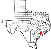
Location of El Campo, Texas | |
 | |
| Coordinates: 29°11′48″N 96°16′24″W / 29.19667°N 96.27333°WCoordinates: 29°11′48″N 96°16′24″W / 29.19667°N 96.27333°W | |
| Country | United States |
| State | Texas |
| County | Wharton |
| Area | |
| • Total | 7.5 sq mi (19.3 km2) |
| • Land | 7.5 sq mi (19.3 km2) |
| • Water | 0.0 sq mi (0.0 km2) |
| Elevation | 105 ft (32 m) |
| Population (2010) | |
| • Total | 11,602 |
| Time zone | Central (CST) (UTC-6) |
| • Summer (DST) | CDT (UTC-5) |
| ZIP code | 77437 |
| Area code(s) | 979 |
| FIPS code | 48-22864[1] |
| GNIS feature ID | 1356861[2] |
| Website | http://www.cityofelcampo.org/ |
El Campo is a city in Wharton County, Texas, United States. The population was 10,945 at the 2000 census, making it the largest city in Wharton County.
Geography
According to the United States Census Bureau, the city has a total area of 7.5 square miles (19.3 km²), all of it land.
Demographics
| Historical population | |||
|---|---|---|---|
| Census | Pop. | %± | |
| 1910 | 1,778 | — | |
| 1920 | 1,766 | −0.7% | |
| 1930 | 2,034 | 15.2% | |
| 1940 | 3,906 | 92.0% | |
| 1950 | 6,237 | 59.7% | |
| 1960 | 7,700 | 23.5% | |
| 1970 | 9,332 | 21.2% | |
| 1980 | 10,462 | 12.1% | |
| 1990 | 10,511 | 0.5% | |
| 2000 | 10,945 | 4.1% | |
| 2010 | 11,602 | 6.0% | |
| Est. 2015 | 11,604 | [3] | 0.0% |
As of the census[1] of 2010, Population in April 2013: 11,486 residing in the city. Population change since 2010: -1.0%
- Males: 48%
- Females: 52%
- Median resident age: 34.1 years
- Texas median age: 32.3 years
The population density was 1,400 people per square mile. There were 4,491 housing units at an average density of 577.5 per square mile (222.9/km²). The racial makeup of the city was 76.1% White, 10.9% African American, 0.33% Native American, 0.5% Asian, 0.01% Pacific Islander, 16.66% from other races, and 1.77% from two or more races. Hispanic or Latino of any race were 47.0% of the population.
There were 3,916 households out of which 37.3% had children under the age of 18 living with them, 53.1% were married couples living together, 13.5% had a female householder with no husband present, and 28.5% were non-families. 25.8% of all households were made up of individuals and 14.4% had someone living alone who was 65 years of age or older. The average household size was 2.91 and the average family size was 3.31.
In the city the population was spread out with 29.3% under the age of 18, 9.5% from 18 to 24, 26.2% from 25 to 44, 19.4% from 45 to 64, and 14.2% who were 65 years of age or older. The median age was 34 years. For every 100 females there were 92.0 males. For every 100 females age 18 and over, there were 86.8 males.
The median income for a household in the city was $40,698. Males had a median income of $27,416 versus $18,872 for females. The per capita income for the city was $14,464. About 16.5% of families and 23.6% of the population were below the poverty line.
- US Post Office on S. Mechanic Street (Hwy. 71)
- Silos along the railroad from Washington Street
Education
Education in the city of El Campo is provided by the El Campo Independent School District and a number of private schools.
- El Campo High School is located on W. Norris Street.
- El Campo Middle School is north of town on FM 2765.
- Historical Commission marker is in front of St. Phillip Catholic Church, which has a school.
Notable people
- Dallas-based radio minister Charles Swindoll was born in El Campo (as mentioned on his broadcast of 16 May 2012).
- Medal of Honor recipient Raul (Roy) Benavidez was raised in El Campo from the age of 7.
- St. Johns Mavericks football coach Melvin Baker.
Climate
The climate in this area is characterized by hot, humid summers and generally mild to cool winters. According to the Köppen Climate Classification system, El Campo has a humid subtropical climate, abbreviated "Cfa" on climate maps.[5]
References
- 1 2 "American FactFinder". United States Census Bureau. Retrieved 2008-01-31.
- ↑ "US Board on Geographic Names". United States Geological Survey. 2007-10-25. Retrieved 2008-01-31.
- ↑ "Annual Estimates of the Resident Population for Incorporated Places: April 1, 2010 to July 1, 2015". Retrieved July 2, 2016.
- ↑ "Census of Population and Housing". Census.gov. Retrieved June 4, 2015.
- ↑ Climate Summary for El Campo, Texas
External links
| Wikimedia Commons has media related to El Campo, Texas. |
- City of El Campo
- City Development Corporation of El Campo, Texas
- El Campo Chamber of Commerce
- El Campo City Data
- El Campo, Texas from the Handbook of Texas Online
- El Campo Museum of Natural History
