Eliot Memorial Bridge
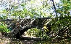
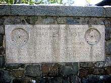
The Eliot Memorial Bridge is a footbridge which was built in 1904 in memory of Charles Eliot, landscape architect to the Metropolitan Park Commission. It is located on the Skyline Trail near the summit of Great Blue Hill in the Blue Hills Reservation, south of Boston, Massachusetts. Eliot was a driving force in the establishment of many of the Greater Boston area's early parks, including the Blue Hill Reservation. The bridge was built out of locally-quarried granite, and completed c. 1905-06. Built into its structure are a bench and commemorative plaque.[3] The bridge, which crosses a small ravine, is a remarkably large and sturdy structure for the location.
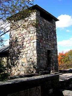
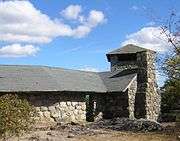
The Great Blue Hill Observation Tower, known locally as Eliot Tower, a 35-foot-tall (11 m) stone structure, was built by the Civilian Conservation Corps (CCC).[2] Its rubble stone base is joined to that of the bridge and the two appear now to have been built together. The tower offers view over about 270°, including all of Boston, Boston Harbor, and much of the South Shore.
The two lie near the 635-foot (194 m) summit of Great Blue Hill, a few hundred yards from and a little below the Great Blue Hill Weather Observatory, which is at the top of the mountain. The view from the observation tower toward the Observatory and its forest of radio, TV, and microwave antennas, is obscured by trees.
Both the bridge and tower were added to the National Register of Historic Places in 1980.[1]
Gallery
See also
References
|
|---|
|
| Topics | | |
|---|
|
| Lists by county | |
|---|
|
| Lists by city | Barnstable County | |
|---|
| Bristol County | |
|---|
| Essex County | |
|---|
| Hampden County | |
|---|
| Middlesex County | |
|---|
| Norfolk County | |
|---|
| Suffolk County | |
|---|
| Worcester County | |
|---|
|
|---|
|
| Other lists | |
|---|
|
-
 Category Category
-
 NRHP portal NRHP portal
- Massachusetts portal
|