Elliot Lake Municipal Airport
| Elliot Lake Municipal Airport | |||||||||||
|---|---|---|---|---|---|---|---|---|---|---|---|
 | |||||||||||
|
IATA: YEL – ICAO: CYEL – WMO: 71268 | |||||||||||
| Summary | |||||||||||
| Airport type | Public | ||||||||||
| Owner/Operator | City of Elliot Lake | ||||||||||
| Location | Elliot Lake | ||||||||||
| Time zone | EST (UTC−05:00) | ||||||||||
| • Summer (DST) | EDT (UTC−04:00) | ||||||||||
| Elevation AMSL | 1,086 ft / 331 m | ||||||||||
| Coordinates | 46°21′06″N 082°33′40″W / 46.35167°N 82.56111°WCoordinates: 46°21′06″N 082°33′40″W / 46.35167°N 82.56111°W | ||||||||||
| Map | |||||||||||
 CYEL Location in Ontario | |||||||||||
| Runways | |||||||||||
| |||||||||||
| Statistics (2010) | |||||||||||
| |||||||||||
Elliot Lake Municipal Airport, (IATA: YEL, ICAO: CYEL), is a registered aerodrome located 4 nautical miles (7.4 km; 4.6 mi) southeast of the city of Elliot Lake, Ontario, Canada.
Facilities
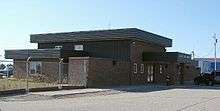
The airport consists of a small brick single storey terminal building. Other than a small waiting area there are no other services inside. Food is available for pilots only.[4]
To the west of the terminal are storage sheds and hangars for general aviation aircraft.
Tenants
There are no schedule airlines operating to and from this airport, but facilities exists to handle them.[5]
Current tenants include:[5]
- Air Bravo – air ambulance operator based in Blind River, Ontario and flies to and from Elliot Lake[6]
- Mining company transport – 2 flights transport to Red Lake every two weeks
- Dynamex – logistics and freight services operator flies to and from Elliot Lake on contracts to clients in the area
- Private flight for an ear/nose/throat specialist who flies into Elliot Lake once a week
- Hope Air – provides free medical transport to those in need in the area[7]
The closest airport with scheduled passenger services is Sault Ste. Marie Airport and Greater Sudbury Airport.
Technical information
General
- Magnetic Variation: 9° west
The aerodrome is operated by the City of Elliot Lake and is registered by Transport Canada.
Runways
- Runway 12/30: 4,495 by 100 ft (1,370 by 30 m), paved, lighted, PAPI type 2 approach lighting at both ends
Communications
- Unicom/ATF: Elliot Lake Unicom/Traffic 123.0 MHz
- PAL: Toronto Centre 135.4 MHz
Navigation aid
- NDB: Elliot Lake (YEL), 276 kHz, 2.7 nautical miles (5.0 km; 3.1 mi) 123° to airport
References
- ↑ Canada Flight Supplement. Effective 0901Z 15 September 2016 to 0901Z 10 November 2016
- ↑ Synoptic/Metstat Station Information
- ↑ Total aircraft movements by class of operation
- ↑ Elliot Lake Airport at COPA
- 1 2 Elliot Lake Airport - General Information
- ↑ Air Bravo Corp - Air Ambulance
- ↑ Hope Air
External links
- Past three hours METARs, SPECI and current TAFs for Elliot Lake Municipal Airport from Nav Canada as available.
| By name | |
|---|---|
| By location indicator | |
| By province/territory | |
| By region | |
| National Airports System | |
| Related | |
| |