Elliot Lake
| Elliot Lake | |
|---|---|
| City (single-tier) | |
| City of Elliot Lake | |
|
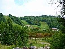
The city of Elliot Lake; the lake on the right | |
 Elliot Lake Location in Ontario | |
| Coordinates: 46°23′N 82°39′W / 46.383°N 82.650°WCoordinates: 46°23′N 82°39′W / 46.383°N 82.650°W | |
| Country |
|
| Province |
|
| District | Algoma |
| Established | 1955 |
| Government | |
| • Mayor | Dan Marchisella |
| • Governing Body | Elliot Lake City Council |
| • Federal electoral district | Algoma—Manitoulin—Kapuskasing |
| • Provincial electoral district | Algoma—Manitoulin |
| Area[1] | |
| • Land | 714.56 km2 (275.89 sq mi) |
| Population (2011)[1] | |
| • Total | 11,348 |
| • Density | 15.9/km2 (41/sq mi) |
| Time zone | Eastern Standard Time (EST) (UTC-5) |
| • Summer (DST) | Eastern Daylight Time (EDT) (UTC-4) |
| Postal Code FSA | P5A |
| Area code(s) | 705 |
| Website | www.cityofelliotlake.com |
| Municipal rank: 325th in Canada | |

Elliot Lake is a city in Algoma District, Ontario, Canada. It is north of Lake Huron, midway between the cities of Sudbury and Sault Ste. Marie in the Northern Ontario region.
History
Prior to the settlement of the city, an Ojibwa village existed near the present hospital site on the lake's shoreline.
The city was established as a planned community for the mining industry in 1955 after the discovery of uranium in the area, and named after the small lake on its northern edge. By the late 1950s, its population had grown to about 25,000.[2] It was originally incorporated as an improvement district. Geologist Franc Joubin and American financier Joseph Hirshhorn were instrumental in its founding. The principal mining companies were Denison Mines and Rio Algom. The population has varied with several boom-and-bust cycles from the 1950s to the 1990s, from a high of over 26,000 to a low of about 6,600.
In 1959, the United States declared that it would buy no more uranium from Canada after 1962. During the 1970s, federal plans for CANDU Reactors and Ontario Hydro's interest in atomic energy led the town, anticipating a population of 30,000, to expand again. However, by the early 1990s depleted reserves and low prices caused the last mines in the area to close.
Elliot Lake was incorporated as a city in 1990. In the years since, the city looked elsewhere for its survival, finding some success promoting itself as a retirement community[2] and tourist destination. In the late 2000s, mineral exploration began taking place in the area, with at least one new mine under preliminary development by start-up miner Pele Mountain Resources.[3]
On June 23, 2012, part of a roof collapsed at Algo Centre Mall, sending metal and concrete debris crashing down through two floors of the shopping centre. The accident killed two people.[4] Pearson Plaza is under construction, set for a late 2016 open.
Uranium mining
Area uranium mines
- Stanleigh Mine (1956–1960 and 1982–1997), operated by Rio Algom Ltd., produced 14 million tons of ore.
- Spanish American Mine (1957–1959), operated by Rio Algom Ltd., produced 79,000 tons of ore.[5]
- Can-Met Mine (1957–1960), operated by Denison Mines Ltd., produced 2.6 million tons of ore.
- Milliken Mine (1957–1964), operated by Rio Algom Ltd., produced 6.3 million tons of ore.
- Panel Mine (1957–1961 and 1978–1990), operated by Rio Algom Ltd., produced 15 million tons of ore.
- Denison Mine (1957–1992), operated by Denison Mines Ltd., produced 69 million tons of ore.
- Stanrock Mine (1958–1960 and 1964–1985), operated by Denison Mines Ltd., produced 6.4 million tons of ore.
- Quirke Mine(s) (1955–1961 and 1965–1990), operated by Rio Algom Ltd., produced 44 million tons of ore.
- Pronto Mine (1955–1970), operated by Rio Algom Ltd., produced 2.3 million tons of ore.
- Buckles Mine (1956–1960), operated by Rio Algom Ltd., produced 276,000 tons of ore.
- Lacnor Mine "Lake Nordic" (1956–1960), operated by Rio Algom Ltd., produced 3.4 million tons of ore.
- Nordic Mine (1956–1970), operated by Rio Algom Ltd., produced 13 million tons of ore.
Health concerns
In 1974, uranium miners in Elliot Lake became alarmed about the high incidence of lung cancer and silicosis, and they went on strike over health and safety conditions. The government appointed a Royal Commission to investigate health and safety in mines. Chaired by Dr. James Ham, it became known as the Ham Commission.[6] According to University of Toronto history professor Laurel Sefton MacDowell in her 2012 article 'The Elliot Lake Uranium Miners’ Battle to Gain Occupational Health and Safety Improvements, 1950–1980', the health concerns over radiation in the local environment are perpetual, and must be monitored perpetually.[7]
Geography and environment

Situated on the Canadian Shield, the city is surrounded by dense forest, muskeg swamps, numerous lakes, winding rivers, and hills of Precambrian bedrock. The local forests are mixed deciduous and coniferous, with colourful displays in the autumn.
Local wildlife include moose, white-tailed deer, American black bear, beaver, loon, muskrat, otter, Canada goose, and lynx, to name but a few. Fish species include lake trout, speckled trout, rainbow trout, smallmouth bass, pickerel (walleye), and sturgeon.
Since December 1990 the town has been home to the Elliot Lake Research Field Station, established by Laurentian University to investigate environmental radioactivity.
Acclaimed Canadian photographer Edward Burtynsky has taken landscape pictures of uranium and nickel tailings during the mid-1990s, providing evidence of the after-effects to the ecosystem.
Climate
- Average precipitation: 1042 mm
| Climate data for Elliot Lake Airport (1981−2010) | |||||||||||||
|---|---|---|---|---|---|---|---|---|---|---|---|---|---|
| Month | Jan | Feb | Mar | Apr | May | Jun | Jul | Aug | Sep | Oct | Nov | Dec | Year |
| Record high humidex | 6.2 | 10.0 | 18.0 | 32.1 | 36.0 | 44.0 | 42.3 | 43.0 | 36.2 | 32.2 | 18.5 | 10.1 | 44.0 |
| Record high °C (°F) | 8.0 (46.4) |
10.0 (50) |
17.8 (64) |
25.5 (77.9) |
31.2 (88.2) |
32.4 (90.3) |
34.0 (93.2) |
34.5 (94.1) |
30.9 (87.6) |
25.4 (77.7) |
18.0 (64.4) |
13.0 (55.4) |
34.5 (94.1) |
| Average high °C (°F) | −6.2 (20.8) |
−3.7 (25.3) |
1.7 (35.1) |
9.8 (49.6) |
16.7 (62.1) |
22.1 (71.8) |
24.0 (75.2) |
23.2 (73.8) |
18.6 (65.5) |
10.8 (51.4) |
3.6 (38.5) |
−3.0 (26.6) |
9.8 (49.6) |
| Daily mean °C (°F) | −10.9 (12.4) |
−8.8 (16.2) |
−3.6 (25.5) |
4.5 (40.1) |
11.1 (52) |
16.5 (61.7) |
18.6 (65.5) |
17.8 (64) |
13.5 (56.3) |
6.5 (43.7) |
0.1 (32.2) |
−7.0 (19.4) |
4.9 (40.8) |
| Average low °C (°F) | −15.6 (3.9) |
−13.8 (7.2) |
−8.8 (16.2) |
−0.8 (30.6) |
5.4 (41.7) |
10.8 (51.4) |
13.1 (55.6) |
12.3 (54.1) |
8.4 (47.1) |
2.1 (35.8) |
−3.4 (25.9) |
−10.9 (12.4) |
−0.1 (31.8) |
| Record low °C (°F) | −37 (−35) |
−33 (−27) |
−32 (−26) |
−15 (5) |
−6 (21) |
−1 (30) |
4.0 (39.2) |
4.0 (39.2) |
−5.5 (22.1) |
−9 (16) |
−21 (−6) |
−32.6 (−26.7) |
−37 (−35) |
| Record low wind chill | −44.6 | −40.3 | −33 | −23.3 | −9.1 | 0.0 | 0.0 | 0.0 | −6.3 | −12.7 | −30.5 | −42.8 | −44.6 |
| Average precipitation mm (inches) | 66.4 (2.614) |
49.8 (1.961) |
63.0 (2.48) |
73.1 (2.878) |
84.9 (3.343) |
84.9 (3.343) |
86.4 (3.402) |
101.7 (4.004) |
102.0 (4.016) |
110.5 (4.35) |
92.8 (3.654) |
93.2 (3.669) |
1,008.8 (39.717) |
| Average rainfall mm (inches) | 17.9 (0.705) |
9.7 (0.382) |
31.3 (1.232) |
62.0 (2.441) |
84.4 (3.323) |
84.9 (3.343) |
86.4 (3.402) |
101.7 (4.004) |
102.0 (4.016) |
107.1 (4.217) |
67.7 (2.665) |
27.6 (1.087) |
782.7 (30.815) |
| Average snowfall cm (inches) | 62.1 (24.45) |
48.7 (19.17) |
35.1 (13.82) |
10.6 (4.17) |
0.61 (0.24) |
0.0 (0) |
0.0 (0) |
0.0 (0) |
0.0 (0) |
2.5 (0.98) |
23.4 (9.21) |
76.0 (29.92) |
259.0 (101.97) |
| Average precipitation days (≥ 0.2 mm) | 12.2 | 10.5 | 8.8 | 9.5 | 11.5 | 11.9 | 10.6 | 10.2 | 11.8 | 13.3 | 12.3 | 14.6 | 137.3 |
| Average rainy days (≥ 0.2 mm) | 2.0 | 1.7 | 3.6 | 7.7 | 11.3 | 11.9 | 10.6 | 10.2 | 11.8 | 12.9 | 8.0 | 3.3 | 95.1 |
| Average snowy days (≥ 0.2 cm) | 11.4 | 9.8 | 6.4 | 2.9 | 0.29 | 0.0 | 0.0 | 0.0 | 0.0 | 0.75 | 5.4 | 13.1 | 50.0 |
| Average relative humidity (%) | 81.0 | 77.0 | 66.5 | 55.0 | 51.1 | 55.1 | 56.5 | 57.4 | 61.0 | 64.1 | 76.7 | 82.3 | 65.3 |
| Source: Environment Canada[8] | |||||||||||||
Demographics
| Historical populations | ||
|---|---|---|
| Year | Pop. | ±% |
| 1971 | 9,093 | — |
| 1981 | 16,723 | +83.9% |
| 1991 | 14,089 | −15.8% |
| 1996 | 13,588 | −3.6% |
| 2001 | 11,956 | −12.0% |
| 2006 | 11,549 | −3.4% |
| 2011 | 11,348 | −1.7% |
| Canada census – Elliot Lake community profile | |||
|---|---|---|---|
| 2011 | 2006 | 2001 | |
| Population: | 11,348 (-1.7% from 2006) | 11,549 (-3.4% from 2001) | 11,956 (-12.0% from 1996) |
| Land area: | 714.56 km2 (275.89 sq mi) | 698.12 km2 (269.55 sq mi) | 698.12 km2 (269.55 sq mi) |
| Population density: | 15.9/km2 (41/sq mi) | 16.5/km2 (43/sq mi) | 17.1/km2 (44/sq mi) |
| Median age: | 57.1 (M: 56.5, F: 57.6) | 54.8 (M: 54.7, F: 54.8) | 49.4 (M: 49.6, F: 49.1) |
| Total private dwellings: | 6245 | 6061 | 6148 |
| Median household income: | $36,366 | $29,323 | |
| References: 2011[9] 2006[10] 2001[11] | |||
Transportation
Relatively isolated, Elliot Lake is connected to the south only by Highway 108, a 30 km distance to Highway 17, also known as the Trans-Canada Highway. North of the city, Highway 639 extends for 24 kilometres to its terminus at Highway 546, an almost entirely unpopulated route used primarily as an access road to Mississagi Provincial Park and a few private wilderness recreation lodges. The Deer Trail Route, a part of the Ontario Tourist Route network, follows a circle consisting of Highways 17, 108, 639 and 546.
A 1991 study by the Ontario Ministry of Transportation proposed the extension of Highway 555 (Granary Lake Road) from Blind River to meet Spine Road in Elliot Lake, creating a new route which would reduce the length of a commute between the two communities by approximately 20 kilometres.[12] Although the ministry has announced no firm plans to construct the proposed road, Elliot Lake City Council passed a motion in August 2015 calling for the project's revival.[12]
Elliot Lake Municipal Airport has no regularly scheduled flights.
Elliot Lake Transit provides hourly bus service except on Sundays and statutory holidays.
Arts and culture
Local festivals include the Jewel in the Wilderness Festival, Heritage Weekend and the Elliot Lake Arts on the Trail festival.[13]
The city is home to Denison House, a hotel and convention facility located in the former corporate lodge of Denison Mines, and the Elliot Lake Mining and Nuclear Museum. Two community monuments, the Uranium Atom Monument downtown and the Miners Memorial Monument on Horne Lake, are also found in the city, as well as a scenic lookout at the former fire tower.
In 1975, Canadian musician Stompin' Tom Connors recorded "Damn Good Song for a Miner," about the city of Elliot Lake and its mining culture in the 1960s. Elliot Lake is also a prominent setting in Alistair MacLeod's award-winning novel No Great Mischief.
Tourist attractions
- The Elliot Lake fire tower lookout overlooks the city.
- Mount Dufour - Ski area with 2 lifts and 7 trails, 320 feet (98 m) vertical and 100% snowmaking capability
- Elliot Lake Nuclear and Mining Museum / Canadian Mining Hall of Fame
Education
Current schools
- Elliot Lake Secondary School
- Villa Française des Jeunes
- Our Lady of Fatima
- Our Lady of Lourdes
- École Georges Vanier
- Esten Park Public School
- Central Avenue Public School
Defunct schools
- Elliot Lake Middle School
- Dieppe Avenue Public School
- Lakeside Avenue Public School
- Stanrock Public School
- Spruce Avenue Public School
- Westhill Senior Public School
- Ecole Notre Dame du Bois Joli
- Holy Family Catholic School
- Roman Avenue Public School
Defunct postsecondary and adult schools
- Sault College (Satellite Campus) - closed
- Collège Boréal (Satellite Campus) - replaced with Access Centre to assist locals in finding employment
- White Mountain Academy of the Arts - closed 2006
Sports
- Elliot Lake ATV Club
- Stone Ridge Golf & Country Club
- Mount Dufour Ski Area
- OK Tire North Shore Challenge Drag Race
- Mountain Bike Ontario Cup Race
- The Jewel in the Wilderness Ontario Cup Road Race
- Tri-it in the Wilderness Triathlon
- Bell Ididarace Sled Dog Race
- Deer Trail Scenic Touring Route
- Voyageur Hiking Trail
Hockey
- Elliot Lake Wildcats (NOJHL) 2014 +
- Elliot Lake Bobcats (GMJHL) 2007–2014
- Elliot Lake Vikings (NOJHL) 1962-1998
- Elliot Lake Ice (NOJHL) 1998-1999
- Elliot Lake Contractors (GNML) 1986-1992
- Elliot Lake Minor Hockey Association
- Elliot Lake Major Hockey Association
Baseball
- Elliot Lake Fireside Heat
- Elliot Lake Minor Fastball Association
Softball
- Elliot Lake Mixed Slow-pitch (Adult)
- Elliot Lake Mixed Slow-pitch (Youth)
Soccer
- Elliot Lake
Swimming
- Elliot Lake Aquatic Club (ELAC)
Media
Radio
Elliot Lake has one commercial radio station, which operates two transmitters due to signal deficiencies in parts of the city. All of its other radio services are rebroadcasters of stations from Sudbury.
| Frequency | Call sign | Branding | Format | Owner | Notes |
|---|---|---|---|---|---|
| FM 90.3 | CBEC-FM | CBC Radio One | Talk radio, public radio | Canadian Broadcasting Corporation | Rebroadcaster of CBCS-FM Sudbury |
| FM 94.1 | CKNR-FM | Moose FM | Adult contemporary | Vista Broadcast Group | |
| FM 94.1 | CKNR-FM-1 | Moose FM | Adult contemporary | Vista Broadcast Group | Additional transmitter due to signal deficiencies |
| FM 101.7 | CBON-FM-5 | Ici Radio-Canada Première | Talk radio, public radio | Canadian Broadcasting Corporation | Rebroadcaster of CBON-FM Sudbury |
| FM 102.5 | CJTK-FM-3 | KFM | Christian music | Eternacom | Rebroadcaster of CJTK-FM Sudbury |
Television
| OTA channel | Call sign | Network | Notes |
|---|---|---|---|
| 3 (VHF) | CICI-TV-1 | CTV | Rebroadcaster of CICI-TV Sudbury |
Elliot Lake was previously served by CBEC-TV, VHF channel 7, and CBLFT-TV-6, VHF channel 12, which rebroadcast the Toronto-based stations CBLT-DT (CBC Television) and CBLFT-DT (Ici Radio-Canada Télé), respectively. These rebroadcasters were shut down in 2012 due to budget cuts at the Canadian Broadcasting Corporation.
Print and web media
- The Elliot Lake Standard is the city's main newspaper, owned by Osprey Media.
- The North Shore Bulletin is the city's bi-weekly advertising flyer, that also prints current news events.
People from Elliot Lake
- Rick Brebant, hockey player
- Kayt Burgess, writer
- Catharine Dixon, writer
- Christine Girard, weightlifter
- Alex Henry, hockey player
- Wayne Keon, Nipissing First Nation poet, author, musician
- Doug McEwen, hockey player
- Jeremy Stevenson, hockey player
- Zack Stortini, hockey player
- Korey Jarvis, wrestler
See also
References
- 1 2 "Elliot Lake census profile". 2011 Census of Population. Statistics Canada. Retrieved 2012-02-16.
- 1 2 Clyde H. Farnsworth (Jun 3, 1996). "Elliot Lake Journal: Snug Retiree Haven Where Uranium Mine Stood". The New York Times.
- ↑ "Elliot Lake miner edges closer to uranium mine.". Northern Ontario Business, July 1, 2008.
- ↑ "Elliot Lake mall searchers recover 2nd body from debris". . June 27, 2012. Retrieved June 27, 2012. External link in
|publisher=(help) - ↑ Rio Algom Ltd (2001). "Elliot Lake Uranium Mine Site Reclamation: Information Package" (PDF). Retrieved 2009-01-28.
- ↑ http://www.worksmartontario.gov.on.ca/scripts/default.asp?contentID=5-1-1-1#H2
- ↑ http://www.lltjournal.ca/index.php/llt/article/viewFile/5678/6541
- ↑ "Elliot Lake A". Canadian Climate Normals 1981–2010. Environment Canada. Retrieved September 22, 2013.
- ↑ "2011 Community Profiles". Canada 2011 Census. Statistics Canada. July 5, 2013. Retrieved 2012-02-16.
- ↑ "2006 Community Profiles". Canada 2006 Census. Statistics Canada. March 30, 2011. Retrieved 2012-02-16.
- ↑ "2001 Community Profiles". Canada 2001 Census. Statistics Canada. February 17, 2012. Retrieved 2012-02-16.
- 1 2 "Council considers old idea for new road". Elliot Lake Standard, August 5, 2015.
- ↑ . Elliot Lake Standard, September 2008.
External links
| Wikivoyage has a travel guide for Elliot Lake. |
| Wikimedia Commons has media related to Elliot Lake, Ontario. |
 |
Unorganized North Algoma | | ||
| Blind River | |
Unorganized North Algoma | ||
| ||||
| | ||||
| The North Shore | Spanish |
| Cities | 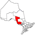 | |
|---|---|---|
| Towns | ||
| Townships | ||
| Villages | ||
| First Nations | ||
| Indian reserves | ||
| Local services boards | ||
| Unorganized areas | ||
| ||