Fairhaven, Minnesota
| Fairhaven, Minnesota | |
|---|---|
| Census-designated place (CDP) and Unincorporated community | |
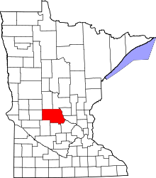
 Fairhaven, Minnesota Location of the community of Fairhaven | |
| Coordinates: 45°19′18″N 94°12′41″W / 45.32167°N 94.21139°WCoordinates: 45°19′18″N 94°12′41″W / 45.32167°N 94.21139°W | |
| Country | United States |
| State | Minnesota |
| County | Stearns |
| Township | Fair Haven Township |
| Area[1] | |
| • Total | 2.055 sq mi (5.32 km2) |
| • Land | 1.908 sq mi (4.94 km2) |
| • Water | 0.147 sq mi (0.38 km2) |
| Elevation | 1,086 ft (331 m) |
| Population (2010)[2] | |
| • Total | 358 |
| • Density | 170/sq mi (67/km2) |
| Time zone | Central (CST) (UTC-6) |
| • Summer (DST) | CDT (UTC-5) |
| ZIP code | 55382 |
| Area code(s) | 320 |
| GNIS feature ID | 643500[3] |
Fairhaven is an unincorporated community and census-designated place (CDP) in Fair Haven Township, Stearns County, Minnesota, United States. Its population was 358 as of the 2010 census.[2]
The community is located near the junction of Stearns County Roads 7 and 44. Nearby places include Kimball, South Haven, Clearwater, and St. Augusta. Stearns County Road 45 is also in the immediate area.
References
- ↑ "US Gazetteer files: 2010, 2000, and 1990". United States Census Bureau. 2011-02-12. Retrieved 2011-04-23.
- 1 2 "American FactFinder". United States Census Bureau. Retrieved 2011-05-14.
- ↑ "Fairhaven, Minnesota". Geographic Names Information System. United States Geological Survey.
Municipalities and communities of Stearns County, Minnesota, United States | ||
|---|---|---|
| Cities |
|  |
| Townships |
| |
| CDP | ||
| Unincorporated communities | ||
| Footnotes | ‡This populated place also has portions in an adjacent county or counties | |
| Core City |  | ||||||
|---|---|---|---|---|---|---|---|
| Surrounding communities |
| ||||||
| Counties | |||||||
‡ indicates that it is partially in the metropolitan area. § indicates a CDP | |||||||
This article is issued from Wikipedia - version of the 4/23/2015. The text is available under the Creative Commons Attribution/Share Alike but additional terms may apply for the media files.