Farragut, Tennessee
| Farragut, Tennessee | |
|---|---|
| Town | |
|
Farragut Town Hall and Folklife Museum | |
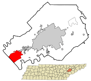 Location in Knox County and the state of Tennessee. | |
| Coordinates: 35°52′39″N 84°10′25″W / 35.87750°N 84.17361°WCoordinates: 35°52′39″N 84°10′25″W / 35.87750°N 84.17361°W | |
| Country | United States |
| State | Tennessee |
| Counties | Knox, Loudon[1] |
| Settled | 1787 |
| Incorporated | 1980 |
| Named for | David Farragut |
| Area | |
| • Total | 16.3 sq mi (42.1 km2) |
| • Land | 16.1 sq mi (41.7 km2) |
| • Water | 0.2 sq mi (0.4 km2) |
| Elevation | 883 ft (269 m) |
| Population (2010)[2] | |
| • Total | 20,676 |
| • Density | 1,101.5/sq mi (425.3/km2) |
| Time zone | Eastern (EST) (UTC-5) |
| • Summer (DST) | EDT (UTC-4) |
| ZIP code | 37922 and 37934 |
| Area code(s) | 865 |
| FIPS code | 47-25760[3] |
| GNIS feature ID | 1284150[4] |
| Website |
www |

Farragut is a town which straddles both Knox and Loudon counties[1] in Tennessee. It is a suburb of Knoxville. The town's population was 20,676 at the 2010 census. It is included in the Knoxville Metropolitan Area. The town is named in honor of American Civil War Admiral David Farragut, who was born just east of Farragut at Campbell's Station in 1801.
History
The area was originally known as Campbell’s Station after a fort and stage coach station erected by Captain David Campbell (1753–1832) in 1787. The brick Campbell's Station Inn was built in 1810 and still stands on Kingston Pike within sight of the Farragut Town Hall. It is still in use as a private residence. The Civil War Battle of Campbell's Station was fought there on November 16, 1863.
The historic unincorporated village of Concord (listed on the National Register of Historic Places) was founded in 1854 just east of what would become the eastern boundary of Farragut. Concord is located on the main rail line to Atlanta and main channel of the Tennessee River, and was an important transloading center for the Tennessee marble industry in the late 19th century. Picturesque buildings and antebellum homes sit along the river, as well as several very old churches.
The original Farragut High School was built by the community in 1904, and moved to its current location in 1976. Some parts of Farragut are zoned for Hardin Valley Academy, built in 2008.
On January 16, 1980, Farragut incorporated as a town, mainly to avoid being annexed by Knoxville, which was trying to shore up its tax base by annexing affluent communities along Kingston Pike.[5] The first mayor, Bob Leonard, was elected April 1, 1980, along with four aldermen. Alderman Eddy Ford became mayor in 1993[6] and served in that position until April 2009, when he failed to win re-election, losing to Dr. Ralph McGill, another of the original founders of the town government.[7]
Geography
Farragut is located at 35°52′39″N 84°10′25″W / 35.87750°N 84.17361°W (35.877511, -84.173548).[8] According to the United States Census Bureau, the town has a total area of 16.2 square miles (42.1 km²), of which 16.1 square miles (41.7 km²) is land and 0.2 square mile (0.4 km²) (1.05%) is water.
Farragut is situated in a hilly area between Blackoak Ridge to the north and the Tennessee River (Fort Loudoun Lake) to the south. Its municipal area is mostly located south of the merged Interstate 40/Interstate 75, with the exception of a few neighborhoods. Kingston Pike, a merged stretch of U.S. Route 70 and U.S. Route 11, traverses the town. Farragut borders Knoxville on the northeast, and the Knox County-Loudon County line forms most of its southwestern boundary. Concord lies immediately southeast of Farragut, and Hardin Valley lies opposite Blackoak Ridge to the north. The small community of Dixie Lee Junction lies along Kingston Pike, just across the Loudon County line.
Demographics
| Historical population | |||
|---|---|---|---|
| Census | Pop. | %± | |
| 1990 | 12,793 | — | |
| 2000 | 17,720 | 38.5% | |
| 2010 | 20,676 | 16.7% | |
| Est. 2015 | 21,919 | [9] | 6.0% |
| Sources:[10][11] | |||
As of the census[3] of 2000, there were 17,720 people, 6,333 households, and 5,231 families residing in the town. The population density was 1,101.5 people per square mile (425.2/km²). There were 6,628 housing units at an average density of 412.0 per square mile (159.0/km²). The racial makeup of the town was 93.88% White, 1.80% African American, 0.15% Native American, 3.16% Asian, 0.33% from other races, and 0.69% from two or more races. Hispanic or Latino of any race were 1.07% of the population.
There were 6,333 households out of which 39.4% had children under the age of 18 living with them, 76.0% were married couples living together, 5.0% had a female householder with no husband present, and 17.4% were non-families. 15.2% of all households were made up of individuals and 5.5% had someone living alone who was 65 years of age or older. The average household size was 2.76 and the average family size was 3.08.
In the town the population was spread out with 26.7% under the age of 18, 5.3% from 18 to 24, 24.4% from 25 to 44, 32.2% from 45 to 64, and 11.4% who were 65 years of age or older. The median age was 42 years. For every 100 females there were 97.8 males. For every 100 females age 18 and over, there were 94.4 males.
The median income for a household in the town was $82,726, and the median income for a family was $91,423. Males had a median income of $70,873 versus $34,955 for females. The per capita income for the town was $35,830. About 2.6% of families and 2.9% of the population were below the poverty line, including 2.9% of those under age 18 and 4.1% of those age 65 or over.
According to the 2007 official Census Bureau estimates, median household income and median family income had risen to $94,420 and $108,236 respectively.[12]
Historic buildings
- Campbell Station Inn
- Avery Russell House
- National Register of Historic Places, Knox County, Tennessee
Education

These schools are a part of Knox County Schools. (Although the school is not in the town limits, Hardin Valley Academy serves parts of Farragut)
- Farragut Primary School (K-2)
- Farragut Intermediate School (3-5)
- Farragut Middle School (6-8)
- Farragut High School (9-12)
- Hardin Valley Academy (9-12)
Notable people
- Bill Bates, NFL player
- Tyson Clabo, NFL player
- David Farragut, Civil War (Union) admiral
- Ben Garant, actor, comedian, writer, director and producer.
- Tim Priest, attorney and Vol Network color commentator
- Archibald Roane, second Governor of Tennessee
- Jerry Sisk, Jr., co-founder of Jewelry Television[13]
Media
- WFIV-FM
- Farragut Press
References
- 1 2 "Subcounty population estimates: Tennessee 2000-2006" (CSV). United States Census Bureau, Population Division. 2007-06-28. Retrieved 2008-05-28.
- ↑ Tennessee Department of Economic and Community Development, Certified Population of Tennessee Incorporated Municipalities and Counties, State of Tennessee website, 1 July 2011.
- 1 2 "American FactFinder". United States Census Bureau. Retrieved 2008-01-31.
- ↑ "US Board on Geographic Names". United States Geological Survey. 2007-10-25. Retrieved 2008-01-31.
- ↑ Steve Ahillen, "Farragut, Knoxville Finally Bury the Ax on Annexation," Knoxville News Sentinel, 30 September 2012. Retrieved: 1 October 2012.
- ↑ "Farragut's Ford Named Mayor of the Year," Tennessee Town & City, July 2, 2007
- ↑ Ralph McGill ousts Eddy Ford as mayor in Farragut; Newcomer bests longtime mayor by 2-to-1 margin, Knoxville News Sentinel, April 8, 2009
- ↑ "US Gazetteer files: 2010, 2000, and 1990". United States Census Bureau. 2011-02-12. Retrieved 2011-04-23.
- ↑ "Annual Estimates of the Resident Population for Incorporated Places: April 1, 2010 to July 1, 2015". Retrieved July 2, 2016.
- ↑ "Census of Population and Housing: Decennial Censuses". United States Census Bureau. Retrieved 2012-03-04.
- ↑ "Incorporated Places and Minor Civil Divisions Datasets: Subcounty Resident Population Estimates: April 1, 2010 to July 1, 2012". Population Estimates. U.S. Census Bureau. Retrieved 11 December 2013.
- ↑ Farragut 2007 Income Estimates
- ↑ "Jerry Sisk, co-founder of Jewelry Television, dead at 59". Knoxville News Sentinel. 2013-01-13. Retrieved 2013-01-23.
Further reading
- Angel, Margaret. Not So Long Ago, In the Concord-Farragut Area : Stories, Paintings and Sketches. (M. Angel, 1986).
External links
| Wikimedia Commons has media related to Farragut, Tennessee. |
| Wikivoyage has a travel guide for Farragut. |
- Town of Farragut website
- Municipal Technical Advisory Service entry for Farragut – information on local government, elections, and link to charter
Municipalities and communities of Knox County, Tennessee, United States | ||
|---|---|---|
| City | ||
| Town | ||
| CDP | ||
| Other unincorporated communities | ||
| Footnotes | ‡This populated place also has portions in an adjacent county or counties | |
Municipalities and communities of Loudon County, Tennessee, United States | ||
|---|---|---|
| Cities | ||
| Towns | ||
| CDP | ||
| Unincorporated communities | ||
| Footnotes | ‡This populated place also has portions in an adjacent county or counties | |
| Principal City |   | |
|---|---|---|
| Other Cities | ||
| Counties | ||