Strawberry Plains, Tennessee
| Strawberry Plains | |
|---|---|
| Unincorporated community | |
| Strawberry Plains | |
|
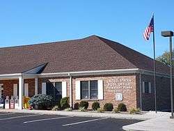
The Post Office in Strawberry Plains, Tennessee | |
 Strawberry Plains  Strawberry Plains Location within the state of Tennessee | |
| Coordinates: 36°3′47″N 83°41′10″W / 36.06306°N 83.68611°WCoordinates: 36°3′47″N 83°41′10″W / 36.06306°N 83.68611°W | |
| Country | United States |
| State | Tennessee |
| Counties | Jefferson, Knox, and Sevier |
| Population (2010) | |
| • Total | 4,667 |
| Time zone | Eastern (EST) (UTC-5) |
| • Summer (DST) | EDT (UTC-4) |
| ZIP codes | 37871 |
| Area code(s) | 865 |
| GNIS feature ID | 1303876[1] |
Strawberry Plains is an unincorporated community straddling the boundary between Jefferson, Knox, and Sevier counties in the U.S. state of Tennessee. Before 2010, it was treated by the United States Census Bureau as a census county division.
Strawberry Plains is located on the bank of the Holston River. According to the United States Geological Survey, a variant is Straw Plains.[1] Strawberry Plains has been the site of a post office since 1806.[2] The zip code is 37871, though parts of Strawberry Plains are located in the zip codes 37914 and 37924.
History
Strawberry Plains is said to be named for the wild strawberries that grew there in abundance when white settlers from North Carolina first arrived in the area.[3] According to a history of the community written by local high school students circa 1935, the name Straw Plains was a shorthand name used by railroad porters and flagmen on trains that passed through Strawberry Plains, and that came to be used as the name of the local railroad depot and on some local post office postmarks.[3]
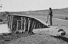
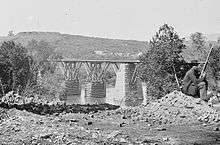
Early in the Civil War, in 1861, the railroad bridge at Strawberry Plains was one target of Union sympathizers who aimed to burn several East Tennessee bridges to hinder Confederate military progress. The conspirators failed in their efforts to burn the Strawberry Plains bridge, but succeeded in their attacks of some of their other targets.
Through much of the 20th century, Strawberry Plains was the site of a Tennessee limestone quarry and an underground zinc mine.[3] The zinc mine shut down in 2001, but reopened in 2006.[4] In December 2008 it was announced that the mine would close again in February 2009.[5]
Economy
In September 2007 the Tennessee Bureau of Investigation announced plans to build an office facility and crime lab in Strawberry Plains, with an estimated cost of more than $10 million.[6] This facility was completed, and opened in July 2009.[7]
The Strawberry Plains exit of Interstate 40, exit 398 at Strawberry Plains Pike has grown rapidly. There are several hotels, restaurants and gas stations, with more under construction.
The Tennessee Department of Transportation's region one headquarters are also located off I-40.
Strawberry Plains has a Food City supermarket, a Family Dollar store, three Dollar General stores and several pharmacies.
Education
Strawberry Plains is home to satellite campuses of Pellissippi State Community College and King University.
Public Schools:
- Jefferson County Schools:
- Rush Strong School
- Knox County Schools:
- Carter Elementary School
- Carter Middle School
- Carter High School
Notable people
References
- 1 2 "Strawberry Plains, Tennessee". Geographic Names Information System. United States Geological Survey.
- ↑ Tennessee Gazetteer and Business Directory 1860-1861
- 1 2 3 History of Strawberry Plains and Its Surrounding Communities, compiled and written by the Ancient History Class at Rush Strong High School circa 1935.
- ↑ With the Reopening of Three Zinc Sites in East Tennessee, Positions Being Added by Michael Silence, Knoxville News Sentinel, November 9, 2006
- ↑ Jake Jost, East Tennessee Zinc Company to mothball 3 mines, lay off 300, WBIR-TV, December 3, 2008
- ↑ TBI to build office facility in Strawberry Plains area, Knoxville News Sentinel, September 20, 2007
- ↑ $17 million regional TBI office opens, "Knoxville News Sentinel", July 29, 2009
Municipalities and communities of Jefferson County, Tennessee, United States | ||
|---|---|---|
| Cities | ||
| Towns | ||
| Unincorporated communities | ||
| Footnotes | ‡This populated place also has portions in an adjacent county or counties | |
Municipalities and communities of Knox County, Tennessee, United States | ||
|---|---|---|
| City | ||
| Town | ||
| CDP | ||
| Other unincorporated communities | ||
| Footnotes | ‡This populated place also has portions in an adjacent county or counties | |
Municipalities and communities of Sevier County, Tennessee, United States | ||
|---|---|---|
| Cities | ||
| Town | ||
| CDPs | ||
| CCDs | ||
| Unincorporated communities | ||
| Footnotes | ‡This populated place also has portions in an adjacent county or counties | |
| Principal City |   | |
|---|---|---|
| Other Cities | ||
| Counties | ||