Fotu La
| Fotu La | |
|---|---|
| फ़ोतु ला | |
|
Fotu La | |
| Elevation | 4,108 m (13,478 ft) |
| Traversed by | Srinagar-Leh highway |
| Location | India |
| Range | Himalaya, Zaskar Range |
| Coordinates | 34°17′38″N 76°42′08″E / 34.29389°N 76.70222°ECoordinates: 34°17′38″N 76°42′08″E / 34.29389°N 76.70222°E |
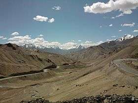
Fotu La (Hindi: फ़ोतु ला) or Fatu La is a mountain pass on the Srinagar-Leh highway in the Himalayas Zaskar Range[1] in India.[2] At an elevation of 4,108 metres (13,478 ft), it is the highest point on the highway, surpassing the famed Zoji La.
Fotu La is one of two high mountain passes between Leh and Kargil, the other being Namika La.[1]
Moving eastwards, the highway begins to descend towards the town of Lamayuru after Fotu La. There is a Prasar Bharati television relay station serving Lamayuru located on the pass.
References
- 1 2 Hilary Keating (July–August 1993). "The Road to Leh". Saudi Aramco World. Houston, Texas: Aramco Services Company. 44 (4): 8–17. ISSN 1530-5821. Retrieved 2009-06-29.
- ↑ GeoNames. "Fotu La Pass". Retrieved 2009-06-17.
This article is issued from Wikipedia - version of the 12/29/2014. The text is available under the Creative Commons Attribution/Share Alike but additional terms may apply for the media files.