Fernacre
 Fernacre stone circle | |
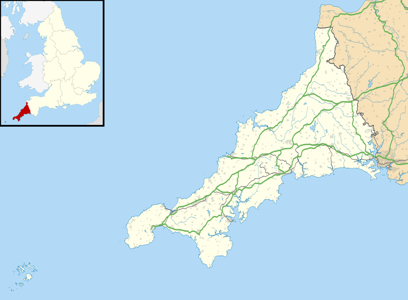 Shown within Cornwall | |
| Location | Bodmin Moor, Cornwall |
|---|---|
| Coordinates | 50°35′24″N 4°37′21″W / 50.58995°N 4.62237°W |
| Type | Stone circle |
| History | |
| Periods | Bronze Age |
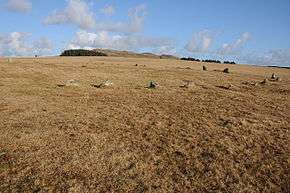
Fernacre, Fernacre stone circle or Fernacre circle (grid reference SX14477997) is a stone circle located on the slopes of the De Lank River, 1.25 miles (2.01 km) northeast of St Breward on Bodmin Moor in Cornwall, UK.[1][2]
Description
It has been suggested to mean bracken-land or come from the old plural for fairy; feren, who were said to be sacred to the ancient Cornish.[3][4] Fernacre is one of the biggest stone circles in Cornwall. It is slightly flattened in a northwest to southeast direction, measuring 46.2 metres (152 ft) by 43.3 metres (142 ft)[5] The circle contains some 68 or 69 stones with a further 3 displaced within, 38 or 39 remain standing upright. They are deeply sunk into the soil with the tallest stone measuring 1.3 metres (4.3 ft) high and the longest fallen stone 2.1 metres (6.9 ft).[6] Fernacre is a marker for the start of a medieval drove road from Rough Tor to Garrow.[2]
Archaeology
The ruins of what was called Fernacre farm were first recorded in 1327 AD.[7] Numerous hut circles dot the landscape nearby and it has been suggested that the dating for Fernacre is contemporary with these.[8] No bones or remains were found in these hut circles, only a few flaked flints gave clues to its occupation.[9] The Fernacre settlement covered 164 acres, of which 84 show signs of having been farmed.[2] The dating of the sites is uncertain although it has been suggested to have been constructed either in the Neolithic or Bronze Age.[10] There are signs that the circle had a retaining bank of earth on its southeast.[11]
Alignments
Fernacre carries a pivotal location between Rough Tor located due north and Brown Willy located due east.[12] Garrow Tor also lies to the east and Louden Hill to the west-southwest. It is only 100 ft from being in a direct line in an easterly direction between Stannon and Brown Willy Cairns, another small erect stone stands in this line eastwards on the way to Brown Willy which has been suggested to mark the equinox sunrise.[4][13] William Page note that when viewed from the centre of Fernacre circle the sunset on 1 May would align approximately with Louden Hill.[14]
Literature
- William Borlase (1754). Observations on the antiquities, historical and monumental, of the county of Cornwall ...: Consisting of several essays on the first inhabitants, Druid-superstition, customs, and remains of the most remote antiquity, in Britain, and the British Isles ... With a summary of the religious, civil, and military state of Cornwall before the Norman Conquest ... Printed by W. Jackson, in the High-Strand.
- William Copeland Borlase (1872). Naenia Cornubiae: the cromlechs and tumuli of Cornwall. Llanerch. ISBN 978-1-897853-36-8.
- William C. Lukis (1885). The prehistoric stone monuments of the British Isles: Cornwall. Printed for Nichols and Sons for the Society of Antiquaries.
- Aubrey Burl (2005). A guide to the stone circles of Britain, Ireland and Brittany. Yale University Press. ISBN 978-0-300-11406-5.
References
- ↑ William C. Lukis (1885). The prehistoric stone monuments of the British Isles: Cornwall. Printed for Nichols and Sons for the Society of Antiquaries. Retrieved 22 March 2011.
- 1 2 3 Karin Altenberg (October 2003). Experiencing landscapes: a study of space and identity in three marginal areas of medieval Britain and Sweden. Almqvist & Wiksell. ISBN 978-91-22-01997-8. Retrieved 23 March 2011.
- ↑ Susan M. Pearce (1981). The archaeology of South West Britain. Collins. p. 212. Retrieved 23 March 2011.
- 1 2 British Association for the Advancement of Science. Meeting; British Association for the Advancement of Science (1908). Report of the annual meeting. Office of the British Association. p. 371. Retrieved 23 March 2011.
- ↑ Aubrey Burl (2005). A guide to the stone circles of Britain, Ireland and Brittany. Yale University Press. pp. 32–. ISBN 978-0-300-11406-5. Retrieved 23 March 2011.
- ↑ William Page (1906). Cornwall. Archibald Constable & Co. p. 394. Retrieved 23 March 2011.
- ↑ Nigel Harvey (1980). The industrial archaeology of farming in England and Wales. B.T. Batsford. ISBN 978-0-7134-1845-3. Retrieved 23 March 2011.
- ↑ Society of Antiquaries of London (1908). Archaeologia, or miscellaneous tracts relating to antiquity. The Society. Retrieved 23 March 2011.
- ↑ American journal of archaeology. 1910. Retrieved 23 March 2011.
- ↑ Prehistoric Society (London; England); University of Cambridge. University Museum of Archaeology and Ethnology (1 January 2005). Proceedings of the Prehistoric Society for ... University Museum of Archaeology and Ethnology. p. 357. Retrieved 23 March 2011.
- ↑ Rodney Castleden (1992). Neolithic Britain: new stone age sites of England, Scotland, and Wales. Routledge. pp. 37–. ISBN 978-0-415-05845-2. Retrieved 23 March 2011.
- ↑ Harold Bayley (October 2004). Archaic England: An Essay in Deciphering Prehistory from Megalithic Monuments Part Two 1919. Kessinger Publishing. pp. 550–. ISBN 978-1-4191-7324-0. Retrieved 23 March 2011.
- ↑ Thomas Rice Holmes (1971). Ancient Britain and the invasions of Julius Caesar. Books for Libraries Press. p. 211. Retrieved 23 March 2011.
- ↑ William Page. The Victoria history of the county of Cornwall. Constable. Retrieved 23 March 2011.
External links
| Wikimedia Commons has media related to Fernacre stone circle. |
- Cornwall's Archaeological Heritage – field guide to accessible sites – Fernacre stone circle
- Illustrated entry in the Megalithic Portal
- Illustrated entry in the Modern Antiquarian
- Pastscape – English Heritage entry about Fernacre stone circle
- Map sources for Fernacre
Cornwall Portal | |
| Unitary authorities | |
| Major settlements |
|
| Rivers | |
| Topics | |