Fieldton, Texas
| Fieldton, Texas | |
|---|---|
| Unincorporated community | |
|
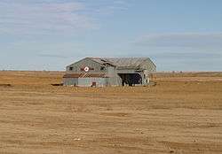
Fieldton cotton gin, constructed in 1931, now abandoned. | |
 Fieldton  Fieldton | |
| Coordinates: 34°02′21″N 102°13′24″W / 34.03917°N 102.22333°WCoordinates: 34°02′21″N 102°13′24″W / 34.03917°N 102.22333°W | |
| Country |
|
| State |
|
| County | Lamb |
| Region | Llano Estacado |
| Established | 1924 |
| Elevation[1] | 3,579 ft (1,091 m) |
| Population (2000) | |
| • Total | 126 |
| Time zone | CST (UTC-6) |
| ZIP code | 79326 |
| Area code | 806 |
| Website | Handbook of Texas |
Fieldton is an unincorporated community in Lamb County, Texas, United States. Although it is unincorporated, Fieldton has a post office, with the ZIP code of 79326.[2]
Geography
Fieldton lies on the high plains of the Llano Estacado in eastern Lamb County at the intersection of Farm to Market roads 37 and 1072, just to the north of Blackwater Draw, a dry tributary of the Double Mountain Fork Brazos River. The community is located 10 mi (16 km) northeast of Littlefield, 11 mi (18 km) southwest of Olton, and 38 mi (61 km) northwest of Lubbock, Texas.
See also
References
External links
- Fieldton, Texas from the Handbook of Texas Online
- U.S. Geological Survey Geographic Names Information System: Fieldton, Texas
- Photos of the Llano Estacado
Municipalities and communities of Lamb County, Texas, United States | ||
|---|---|---|
| Cities | 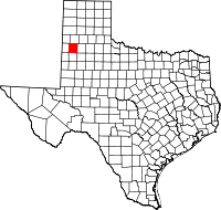 | |
| Town | ||
| CDP | ||
| Unincorporated community | ||
This article is issued from Wikipedia - version of the 11/10/2016. The text is available under the Creative Commons Attribution/Share Alike but additional terms may apply for the media files.