Filmore Township, Bollinger County, Missouri
| Filmore Township | |
|---|---|
| Township | |
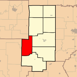 Location in Bollinger County | |
| Coordinates: 37°14′38″N 90°09′54″W / 37.24389°N 90.16500°WCoordinates: 37°14′38″N 90°09′54″W / 37.24389°N 90.16500°W | |
| Country |
|
| State |
|
| County | Bollinger |
| Area | |
| • Total | 60.71 sq mi (157.23 km2) |
| • Land | 60.65 sq mi (157.08 km2) |
| • Water | 0.06 sq mi (0.15 km2) 0.1% |
| Elevation | 636 ft (194 m) |
| Population (2010) | |
| • Total | 488 |
| • Density | 8.03/sq mi (12.92/km2) |
| Time zone | CST (UTC-6) |
| • Summer (DST) | CDT (UTC-5) |
| ZIP codes | 63750, 63751, 63753, 63764, 63787 |
| GNIS feature ID | 0766322 |
Filmore Township is one of eight townships in Bollinger County, Missouri, USA. As of the 2000 U.S. Census, its population was 508. As of the 2010 U.S. Census, the population had decreased to 488. Filmore Township covers an area of 60.71 square miles (157.2 km2).[1]
Filmore Township was established in 1851, and named in honor President Millard Fillmore.[2]
Demographics
As of the 2010 U.S. Census, there were 488 people residing in the township. The population density was 8.03 people per square mile (12.92/km²). There were 308 housing units in the township. The racial makeup of the township was 96.31% White, 0.20% Black or African American, 2.05% Native American, 0.20% from other races, and 1.23% from two or more races. Approximately 0.20% of the population were Hispanic or Latino of any race.
Geography
Incorporated Areas
The township contains no incorporated settlements.
Unincorporated Areas
The township contains the following two unincorporated areas and historical communities:
- Buchanan at 37°12′40″N 90°11′32″W / 37.211163°N 90.19233°W
- Grassy at 37°15′39″N 90°07′25″W / 37.260886°N 90.123717°W
Cemeteries
The township contains the following five cemeteries: Kinder Chapel, Mouser, Patterson, Ray, and Scott.
Streams
The streams of Castor River, Grassy Creek, Little Grassy Creek, Perkins Creek, and Trace Creek flow through Filmore Township.
Landmarks
- Arrowhead Campground[3]
- Blue Pond
- Castor River[4]
- Castor River Conservation Area
- Castor River Park
- Twin Bridges Campground
Transportation
Administrative Districts
School Districts
- Woodland R-IV School District
- Zalma R-V School District
Political Districts
- Missouri's 8th Congressional District
- State House District 145
- State Senate District 27
References
- United States Census Bureau 2008 TIGER/Line Shapefiles
- United States Board on Geographic Names (GNIS)
- United States National Atlas
- ↑ State Historical Society of Missouri: Bollinger County Place Names, 1928-1945 http://shs.umsystem.edu/manuscripts/ramsay/ramsay_bollinger.html
- ↑ "Bollinger County Place Names, 1928-1945 (archived)". The State Historical Society of Missouri. Retrieved 2 September 2016.
- ↑ Arrowheadcampgrounds.com http://www.arrowheadcampgrounds.com/
- ↑ Bollinger County, Missouri Chamber of Commerce http://www.bollingercountychamber.com/recreation.asp
External links
 |
Big Creek Township, Madison County | |
Crooked Creek Township | |
| Cedar Creek Township, Wayne County | |
Liberty Township Lorance Township | ||
| ||||
| | ||||
| Cowan Township, Wayne County | |
Wayne Township |
Municipalities and communities of Bollinger County, Missouri, United States | ||
|---|---|---|
| City | 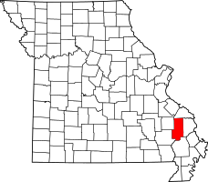 | |
| Villages | ||
| Townships | ||
| Unincorporated communities | ||
| Abandoned villages | ||