Alberta Highway 22X
| ||||
|---|---|---|---|---|
 | ||||
| Route information | ||||
| Length: | 54 km (34 mi) | |||
| Major junctions | ||||
| East end: |
| |||
|
| ||||
| West end: |
| |||
| Location | ||||
| Specialized and rural municipalities: | Wheatland County, Rocky View County, Foothills No. 31 M.D. | |||
| Major cities: | Calgary | |||
| Highway system | ||||
|
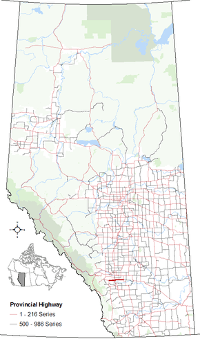
Provincial highways in Alberta
| ||||

Alberta Provincial Highway No. 22X[1] is an east-west highway in Alberta, Canada. It is a spur of Highway 22, a north-south highway.
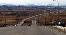
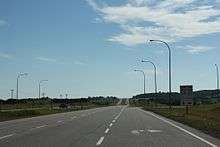
Highway 22X goes from the junction of Highway 24 and Highway 901, westerly to the junction of Highway 22 just east of Priddis over a distance of about 54 km (34 mi). It takes the name Marquis of Lorne Trail when it enters Calgary on its southeast side, and subsequently becomes Stoney Trail as it joins the eastern leg of the ring road. It continues over Highway 2 (Deerfoot Trail within Calgary). When the highway crosses Macleod Trail (Highway 2A), it changes its name to Spruce Meadows Trail, after the show jumping facility of the same name that it passes. About 10 km (6.2 mi) after it exits the west end of the city, the 22X ends at Highway 22 just east of the Hamlet of Priddis.
Contemporary issues
Until it was upgraded in the 2010s as part of the Stoney Trail ring road project, the Marquis of Lorne Trail portion of Highway 22X had earned a reputation of being an accident-prone road. Southward growth of Calgary had turned the small rural highway (it remained a 2-lane rural arterial road for many years) into an urban street that was not suited for high traffic volumes.
Until the late 1990s, all of Highway 22X within the City of Calgary went by the name "Marquis of Lorne Trail", until the owners of Spruce Meadows successfully lobbied the city to rename the portion west of Macleod Trail after the internationally known show-jumping facility. That portion of 22X is now known as "Spruce Meadows Trail". In 2009, the province announced plans to complete the southeastern portion of the Calgary ring road by extending the still-under-construction East Freeway (or Stoney Trail) south from Highway 1A. This project included major upgrades to the Marquis of Lorne segment of 22X west from approximately 88th Street to Macleod Trail. Completed in late 2013, the upgrade resulted in the City renaming Marquis of Lorne Trail west of 88th Street as Stoney Trail and the province also redesignated the highway as Highway 201 (the designation of the rest of Stoney Trail). As of 2015, the Highway 22X designation remains in place west of Macleod Trail and east of where Stoney Trail turns northward; east of the latter the highway also retains the Marquis of Lorne Trail name.
Major intersections
| Rural/specialized municipality | Location | km[2] | mi | Exit | Destinations | Notes |
|---|---|---|---|---|---|---|
| M.D. of Foothills No. 31 | Priddis | 0.0 | 0.0 | Hwy 22X begins | ||
| City of Calgary | 6.5 | 4.0 | 85 Street SW / 144 Street W | Calgary city limits Becomes Spruce Meadows Trail | ||
| 11.3 | 7.0 | 37 Street SW / 96 Street W | Former Hwy 773 south | |||
| 12.4 | 7.7 | Future | Future interchange[3] | |||
| 13.0 | 8.1 | 24 Street SW | ||||
| 13.9 | 8.6 | Tournament Lane – Spruce Meadows | ||||
| 14.7 | 9.1 | James Mckevitt Road / Spruce Meadows Way – Spruce Meadows | Future interchange[3] | |||
| 16.2 | 10.1 | 6 Street SW / Sheriff King Street | Future interchange[3] | |||
| 17.4 | 10.8 | 5 | Partial cloverleaf interchange with traffic signals on Hwy 22X. Hwy 201/22X hidden concurrency begins | |||
| 19.5 | 12.1 | 3 | Sun Valley Boulevard / Chaparral Boulevard | Interchange | ||
| 20.6 | 12.8 | Crosses Bow River | ||||
| 21.9 | 13.6 | 1 | McKenzie Lake Boulevard / Cranston Boulevard | Interchange Eastbound exit, westbound entrance | ||
| 23.1 | 14.4 | 101 | Interchange | |||
| 25.1 | 15.6 | 99 | Interchange Westbound access to Cranston and Auburn Bay | |||
| 27.8 | 17.3 | 96 | 88 Street SE | Interchange Hwy 201 concurrency ends Hwy 22X exits freeway | ||
| 31.2 | 19.4 | 120 Street SE / Range Road 285 | Calgary city limits | |||
| Rocky View County | Indus | 37.4 | 23.2 | Range Road 281A | ||
| | 44.2 | 27.5 | Range Road 273 – Langdon | Former Hwy 797 | ||
| Wheatland County | | 54.1 | 33.6 | Hwy 22X ends | ||
| ||||||
See also
References
- ↑ Provincial Highways Designation Order, Alberta Transportation, p. 5
- ↑ "Google Maps". Google Maps. Retrieved 22 April 2016.
- 1 2 3 "Southwest Calgary Ring Road". Government of Alberta. 31 March 2014. Retrieved 22 April 2016.
External links
- 2010 Provincial Highways 1 - 216 Series Progress Chart (map, 8 MB) by Alberta Transportation.