Fontenelle, Territoire de Belfort
| Fontenelle | ||
|---|---|---|
|
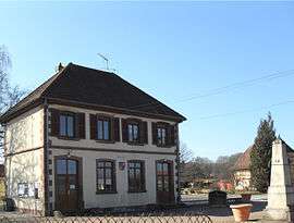
Town hall and World War I memorial | ||
| ||
 Fontenelle | ||
|
Location within Bourgogne-Franche-Comté region  Fontenelle | ||
| Coordinates: 47°37′21″N 6°57′25″E / 47.6225°N 6.9569°ECoordinates: 47°37′21″N 6°57′25″E / 47.6225°N 6.9569°E | ||
| Country | France | |
| Region | Bourgogne-Franche-Comté | |
| Department | Territoire de Belfort | |
| Arrondissement | Belfort | |
| Canton | Danjoutin | |
| Intercommunality | Bassin de la Bourbeuse | |
| Government | ||
| • Mayor (2014–2020) | Jean-Claude Mougin | |
| Area1 | 1.75 km2 (0.68 sq mi) | |
| Population (2006)2 | 116 | |
| • Density | 66/km2 (170/sq mi) | |
| Time zone | CET (UTC+1) | |
| • Summer (DST) | CEST (UTC+2) | |
| INSEE/Postal code | 90048 / 90340 | |
| Elevation | 338–369 m (1,109–1,211 ft) | |
|
1 French Land Register data, which excludes lakes, ponds, glaciers > 1 km² (0.386 sq mi or 247 acres) and river estuaries. 2 Population without double counting: residents of multiple communes (e.g., students and military personnel) only counted once. | ||
.svg.png)
Fontenelle is a commune in the Territoire de Belfort department in Bourgogne-Franche-Comté in northeastern France.
See also
| Wikimedia Commons has media related to Fontenelle. |
References
This article is issued from Wikipedia - version of the 10/29/2016. The text is available under the Creative Commons Attribution/Share Alike but additional terms may apply for the media files.