Warrenton, Oregon
| Warrenton, Oregon | |
|---|---|
| City | |
| Motto: "Making a Difference through excellence of service" | |
 Location in Oregon | |
| Coordinates: 46°9′54″N 123°55′27″W / 46.16500°N 123.92417°WCoordinates: 46°9′54″N 123°55′27″W / 46.16500°N 123.92417°W | |
| Country | United States |
| State | Oregon |
| County | Clatsop |
| Incorporated | 1899 |
| Government | |
| • Mayor | Mark Kujala |
| Area[1] | |
| • Total | 17.66 sq mi (45.74 km2) |
| • Land | 12.77 sq mi (33.07 km2) |
| • Water | 4.89 sq mi (12.67 km2) |
| Elevation | 8 ft (2.4 m) |
| Population (2010)[2] | |
| • Total | 4,989 |
| • Estimate (2014[3]) | 5,173 |
| • Density | 390.7/sq mi (150.9/km2) |
| Time zone | Pacific (UTC-8) |
| • Summer (DST) | Pacific (UTC-7) |
| ZIP code | 97146 |
| Area code(s) | 503 and 971 |
| FIPS code | 41-78900[4] |
| GNIS feature ID | 1136879[5] |
| Website | www.ci.warrenton.or.us |
Warrenton is a city in Clatsop County, Oregon, United States. The city is named for D.K. (Daniel Knight) Warren, an early settler. The population was 4,989 at the 2010 census.
History
The first settlement within the Warrenton city limits was Lexington, which was laid out in 1848, and served as the first county seat for Clatsop County. The name fell out of use, and this area became known as Skipanon, which is preserved in the name of the Skipanon River which flows through the town. A Lexington post office operated intermittently between 1850 and 1857; a Skipanon post office operated without a break from 1871 to 1903.
Fort Stevens was built in the Warrenton area in 1863. Its remains are preserved as part of Lewis and Clark National and State Historical Parks.
Warrenton was platted in 1889, and incorporated as a city in 1899. Built on tidal flats, it relied on a system of dikes built by Chinese laborers to keep the Columbia River from flooding the town.
The pioneers, or first settlers, on the land covered by the town were Jeremiah Gerome Tuller, J. W. Wallace, D. E. Pease, Ninian A. Eberman and George Washington Coffinberry, who located here during the period from 1845 to the early 1850s. Very few improvements were made to the land, however, until the early 1870s, when D. K. Warren bought out some of the first settlers and, with the help of Chinese labor, reclaimed a large tract of the land by constructing a dike about 2.5 miles (4.0 km) in length, which was completed in 1878. Warren laid out the town in about 1891, and in the following year built the first schoolhouse, at a cost of $1,100, and gave it to the school district.[6]
Geography
_(clatDA0042a).jpg)
Warrenton is 8 miles (13 km) west of Astoria across the Youngs Bay bridge spanning over 4,200 feet (1,300 m) of the Youngs Bay estuary at the mouth of the Columbia River.
According to the United States Census Bureau, the city has a total area of 17.66 square miles (45.74 km2), of which, 12.77 square miles (33.07 km2) is land and 4.89 square miles (12.67 km2) is water.[1]
Warrenton has two charter fishing boat ports.
Neighborhoods
Warrenton includes the former communities of Flavel, Fort Stevens, Hammond, and Skipanon.[7] Fort Stevens post office operated at the Fort Stevens military post from 1899 to 1949.[7] Hammond voted to disincorporate in November 1991 and merged with Warrenton on December 5.[7] Hammond was named for lumberman Andrew B. Hammond.[7] Hammond, originally the site of a Clatsop village called Ne-ahk-stow,[8] is separated from Warrenton and has its own zip code of 97121.
Climate
This region experiences warm (but not hot) and dry summers, with no average monthly temperatures above 71.6 °F (22.0 °C). According to the Köppen Climate Classification system, Warrenton has a warm-summer Mediterranean climate, abbreviated "Csb" on climate maps.[9]
Demographics
| Historical population | |||
|---|---|---|---|
| Census | Pop. | %± | |
| 1900 | 332 | — | |
| 1910 | 339 | 2.1% | |
| 1920 | 730 | 115.3% | |
| 1930 | 683 | −6.4% | |
| 1940 | 1,365 | 99.9% | |
| 1950 | 1,896 | 38.9% | |
| 1960 | 1,717 | −9.4% | |
| 1970 | 1,825 | 6.3% | |
| 1980 | 2,493 | 36.6% | |
| 1990 | 2,681 | 7.5% | |
| 2000 | 4,096 | 52.8% | |
| 2010 | 4,989 | 21.8% | |
| Est. 2015 | 5,282 | [10] | 5.9% |
| source:[2][11] | |||
2010 census
As of the census[12] of 2010, there were 4,989 people, 1,948 households, and 1,287 families residing in the city. The population density was 390.7 inhabitants per square mile (150.9/km2). There were 2,196 housing units at an average density of 172.0 per square mile (66.4/km2). The racial makeup of the city was 91.5% White, 0.6% African American, 1.3% Native American, 1.1% Asian, 0.7% Pacific Islander, 1.8% from other races, and 3.0% from two or more races. Hispanic or Latino of any race were 5.7% of the population.
There were 1,948 households of which 31.3% had children under the age of 18 living with them, 48.5% were married couples living together, 11.7% had a female householder with no husband present, 5.9% had a male householder with no wife present, and 33.9% were non-families. 26.4% of all households were made up of individuals and 10% had someone living alone who was 65 years of age or older. The average household size was 2.45 and the average family size was 2.95.
The median age in the city was 37.6 years. 23.8% of residents were under the age of 18; 9.8% were between the ages of 18 and 24; 25.2% were from 25 to 44; 27.4% were from 45 to 64; and 14% were 65 years of age or older. The gender makeup of the city was 51.0% male and 49.0% female.
2000 census
At the 2000 census,[4] there were 4,096 people, 1,621 households and 1,087 families residing in the city. The population density was 332.2 per square mile (128.3/km²). There were 1,799 housing units at an average density of 145.9 per square mile (56.3/km²). The racial makeup of the city was 92.53% White, 0.22% African American, 1.32% Native American, 1.76% Asian, 0.07% Pacific Islander, 1.27% from other races, and 2.83% from two or more races. Hispanic or Latino of any race were 2.91% of the population. 15.4% were of American, 12.1% German, 9.2% English, 8.9% Irish and 8.1% Norwegian ancestry according to Census 2000.
There were 1,621 households of which 33.7% had children under the age of 18 living with them, 52.1% were married couples living together, 11.0% had a female householder with no husband present, and 32.9% were non-families. 26.5% of all households were made up of individuals and 10.2% had someone living alone who was 65 years of age or older. The average household size was 2.49 and the average family size was 3.00.
Age distribution was 26.6% under the age of 18, 8.2% from 18 to 24, 29.8% from 25 to 44, 22.4% from 45 to 64, and 13.1% who were 65 years of age or older. The median age was 37 years. For every 100 females there were 103.0 males. For every 100 females age 18 and over, there were 100.3 males.
The median household income was $33,472, and the median family income was $42,946. Males had a median income of $31,654 versus $21,133 for females. The per capita income for the city was $16,874. About 11.9% of families and 14.2% of the population were below the poverty line, including 19.4% of those under age 18 and 11.7% of those age 65 or over.
Education
Warrenton High School is a small school with a total enrollment of between 250 and 400. Warrenton Grade School is a K-8 school.
Notable people
- Brian Bruney, Major League Baseball pitcher
- Janet Stevenson, writer
References
- 1 2 "US Gazetteer files 2010". United States Census Bureau. Retrieved 2012-12-21.
- 1 2 "Warrenton, Oregon". American FactFinder. U.S. Census Bureau. Retrieved 2013-06-14.
- ↑ "Population Estimates". United States Census Bureau. Retrieved 2015-09-04.
- 1 2 "American FactFinder". United States Census Bureau. Retrieved 2008-01-31.
- ↑ "US Board on Geographic Names". United States Geological Survey. 2007-10-25. Retrieved 2008-01-31.
- ↑ History of the Columbia River Valley From The Dalles to the Sea, Vol. III. The S. J. Clarke Publishing Company. 1928. pp. 526–532.
- 1 2 3 4 McArthur, Lewis A.; McArthur, Lewis L. (2003) [1928]. Oregon Geographic Names (7th ed.). Portland, Oregon: Oregon Historical Society Press. pp. 373, 440. ISBN 978-0875952772.
- ↑ "Hammond". Retrieved 1 June 2016.
- ↑ "Warrenton, Oregon Köppen Climate Classification (Weatherbase)". Retrieved 1 June 2016.
- ↑ "Annual Estimates of the Resident Population for Incorporated Places: April 1, 2010 to July 1, 2015". Retrieved July 2, 2016.
- ↑ Moffatt, Riley Moore (1996). Population History of Western U.S. Cities and Towns, 1850–1990. Lanham, Maryland: Scarecrow Press. p. 217. ISBN 978-0-8108-3033-2.
- ↑ "American FactFinder". United States Census Bureau. Retrieved 2012-12-21.
External links
- Entry for Warrenton in the Oregon Blue Book
- Historic photos of Warrenton from Salem Public Library
- Historic photos of Hammond, Oregon from Salem Public Library
Municipalities and communities of Clatsop County, Oregon, United States | ||
|---|---|---|
| Cities | 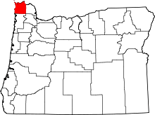 | |
| CDPs | ||
| Other unincorporated communities | ||