Fox Range
| Fox Range | |
|---|---|
| Highest point | |
| Peak | Pah-Rum Peak |
| Elevation | 2,319 m (7,608 ft) [1] |
| Coordinates | 40°23′26″N 119°34′32″W / 40.39056°N 119.57556°W |
| Dimensions | |
| Length | 24 mi (39 km) N_S [5] |
| Width | 9 mi (14 km) E-W [5] |
| Area | 150 sq mi (390 km2) [5] |
| Geography | |
| Country | United States |
| State | Nevada |
| Region | Black Rock Desert |
| District | Washoe County |
| Range coordinates | 40°26′12″N 119°34′07″W / 40.4368°N 119.5685°WCoordinates: 40°26′12″N 119°34′07″W / 40.4368°N 119.5685°W |
| Topo map | USGS Pah-Rum Peak |

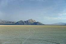
The Fox Range is a mountain range in east central Washoe County, Nevada.[2]
Gerlach, Black Rock Desert and the Granite Range lie to the north and northeast. The Selenite Range is to the east beyond the San Emidio Desert and Poito Valley. The Lake Range lies to the southeast and Pyramid Lake is to the south. The Smoke Creek Desert is to the west. The Pyramid Lake Indian Reservation occupies the southern third of the range.[3][4]
References
- 1 2 Pah-Rum Peak, Nevada 7.5 minute Quad, USGS, 1990
- 1 2 "Fox Range". Geographic Names Information System. United States Geological Survey. Retrieved 2009-05-04.
- 1 2 Kumiva Peak, Nevada, 30x60 minute topographic quad., USGS, 1984
- 1 2 Gerlach, Nevada, 30x60 minute topographic quad., USGS, 1981
- 1 2 3 Measured from Kumiva Peak and Gerlach, NV 30x60 USGS quads
This article is issued from Wikipedia - version of the 6/6/2013. The text is available under the Creative Commons Attribution/Share Alike but additional terms may apply for the media files.