Quinn River
| Quinn River | |
| Queen River | |
| intermittent river | |
 The Quinn River drainage includes an area of Oregon | |
| Country | United States |
|---|---|
| State | Nevada |
| Tributaries | |
| - left | East Fork source: 41°51′03″N 117°27′58″W / 41.850723°N 117.466245°W |
| - right | Kings River |
| Source | W side of the Santa Rosa Range in NE Humboldt Co |
| - location | near Oregon state line |
| - elevation | 3,060 ft (933 m) |
| - coordinates | 41°58′26″N 117°34′8″W / 41.97389°N 117.56889°W |
| Mouth | |
| - coordinates | 40°52′59″N 119°03′50″W / 40.88306°N 119.06389°WCoordinates: 40°52′59″N 119°03′50″W / 40.88306°N 119.06389°W |
| Length | 110 mi (177 km) |
| Basin | 6,720 sq mi (17,405 km2) [1] |
| Discharge | for Quinn River Sink, ~60 miles (97 km) northwest of Winnemucca, Nevada |
| - average | 0 cu ft/s (0 m3/s) (evaporation) |
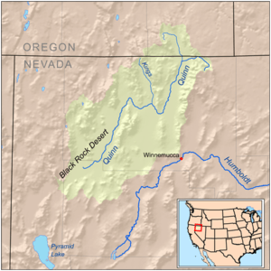
The Quinn River, once known as the Queen River, is an intermittent river, approximately 110 miles (180 km) long, in the desert of northwestern Nevada in the United States. It drains an enclosed basin inside the larger Great Basin.
It rises in northeastern Humboldt County, on the west side of the Santa Rosa Range, just south of the Oregon state line. Its course flows southwest, through the main Nevada lands of the Fort McDermitt Paiute and Shoshone Tribes and then south and southwest, receiving the Kings River flowing south from Kings River Valley. The Quinn River evaporates in a sink at the Black Rock Desert approximately 60 miles (97 km) northwest of Winnemucca on the Hog John Ranch of the Fort McDermitt Paiute-Shoshone Tribe.
Catchment
The Quinn River is the largest river in the region, starting in the Santa Rosa Range and ending in the Quinn River Sink on the playa south of the Black Rock Range. The watershed covers 11,600 sq mi (30,000 km2)[1] including the Upper and Lower Quinn River, Smoke Creek Desert, Massacre Lake, and Thousand Creek[2]/Virgin Valley[3] watersheds of northwestern Nevada as well as small parts across the borders of California and Oregon.
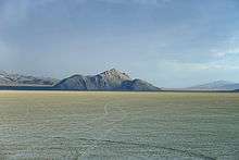
Quinn River Sink
The Quinn River Sink is the mouth of the Quinn River[4] and is a geographic sink of around 3 square miles (7.8 km2) is where the Quinn River discharges and evaporates about 2.75 miles (4.43 km) south-southwest of Black Rock Hot Springs.[5]
See also
References
- 1 2 Boundary Descriptions and Names of Regions, Subregions, Accounting Units and Cataloging Units, United States Geological Survey, April 2, 2007, retrieved 2008-01-11
- ↑ "Thousand Creek". Geographic Names Information System. United States Geological Survey. Retrieved 2008-01-13.
- ↑ "Virgin Valley". Geographic Names Information System. United States Geological Survey. Retrieved 2008-01-13.
- ↑ "General Information". Friends of the Black Rock. Retrieved 2010-11-24.
- ↑ Black Rock Desert-High Rock Canyon Emigrant Trails NCA (Map). BLM.gov.