Nevada State Route 34
| |
|---|---|
| Route information | |
| Existed: | ? – 1978 |
| Major junctions | |
| South end: |
|
|
Former | |
| North end: | Coleman Valley Road |
| Highway system | |
| |

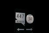
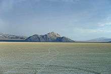
Former SR 34[1] is a signed decommissioned State highway in Nevada from prior to the state's highway restructuring in 1978. Today a portion of former SR 34 is maintained by the Washoe County as a county highway with the not well known designation CR 34.[2] A portion of State Route 447 was formerly SR 34,[3] though the former SR 34 road bed is still used from Gerlach, Nevada to near Vya, Nevada.[4]
History
In the 1950s the pavement ended and became gravel[5] just past the sand dunes north of Nixon. In 1953, south of Gerlach, the paving was incomplete and State Route 81 from Gerlach to the California state line was not surfaced.[6] By 1963, the road was paved to Gerlach[7] and State Route 81 was partly paved from Gerlach to the California State Line.
Before 1978 SR 34 followed present day SR 447 route, from Gerlach to Wadsworth, Nevada.[8]
Major intersections
The entire route is in Washoe County.
| Location | mi | km | Destinations | Notes | |
|---|---|---|---|---|---|
| Gerlach | To SR 447 | ||||
| | Northern end of CR 34 and southern end of SR 34 | ||||
| Vya | Southern end of SR 8A overlap | ||||
| | Northern end of SR 8A overlap | ||||
| Oregon state line | Coleman Valley Road | To OR 140 – Adel, Lakeview, Denio | |||
| 1.000 mi = 1.609 km; 1.000 km = 0.621 mi | |||||
References
- ↑ Official Road Map of the State of Nevada (Map). Nevada Department of Highways. 1941. Retrieved December 30, 2007.
- ↑ "Budget Presentation FY 2008‐2009" (PDF). Washoe County Department of Public Works. p. 14. Retrieved August 29, 2009.
- ↑ "Nevada's State Maintained Highways, Descriptions, Index and Maps" (PD). p. 120. Retrieved December 30, 2007.
- ↑ "Nevada Log: Routes 0 through 99". Retrieved December 30, 2007.
- ↑ Wilson, Larry. "Small towns hit the 'bust' in Nevada's 'boom and bust' history". Daily Sparks Tribune.
- ↑ Burns, John & Johnson, Frank (April 26, 1953). "Residents of Gerlach Like to Think of It As One of the last Genuine Frontier Towns". Nevada State Journal. Retrieved February 9, 2013.
- ↑ Sinclair, W.C. (October 1, 1963). Ground Water Appraisal of the Black Rock Desert Area, Northwestern Nevada (PDF) (Technical report). Nevada Bureau of Mines and Geology. 20.
- ↑ Official Highway Map of Nevada (Map) (1978–79 ed.). Nevada Department of Highways. 1978.