Fremont Township, Steuben County, Indiana
| Fremont Township | |
|---|---|
| Township | |
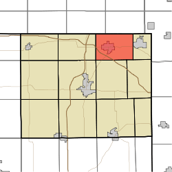 Location in Steuben County | |
| Coordinates: 41°44′02″N 84°55′03″W / 41.73389°N 84.91750°WCoordinates: 41°44′02″N 84°55′03″W / 41.73389°N 84.91750°W | |
| Country | United States |
| State | Indiana |
| County | Steuben |
| Government | |
| • Type | Indiana township |
| Area | |
| • Total | 23.15 sq mi (60.0 km2) |
| • Land | 22.94 sq mi (59.4 km2) |
| • Water | 0.21 sq mi (0.5 km2) 0.91% |
| Elevation | 1,060 ft (323 m) |
| Population (2010) | |
| • Total | 2,993 |
| • Density | 130.5/sq mi (50.4/km2) |
| GNIS feature ID | 453317 |
Fremont Township is one of twelve townships in Steuben County, Indiana, United States. As of the 2010 census, its population was 2,993 and it contained 1,224 housing units.[1]
Geography
According to the 2010 census, the township has a total area of 23.15 square miles (60.0 km2), of which 22.94 square miles (59.4 km2) (or 99.09%) is land and 0.21 square miles (0.54 km2) (or 0.91%) is water.[1] Lakes in this township include Eaton Lake, Fish Lake and Walters Lake.
Cities and towns
Cemeteries
The township contains four cemeteries: Bower, Coventer (also known as Ray Cemetery), Lakeside, and Fremont Cemetery (listed by the USGS as "The Old Cemetery").[2]
Major highways
References
- "Fremont Township, Steuben County, Indiana". Geographic Names Information System. United States Geological Survey. Retrieved 2009-09-24.
- "Steuben County Cemeteries", Steuben County, Indiana, INGenWeb Site, accessed August 12, 2008.
- United States Census Bureau cartographic boundary files
- 1 2 "Population, Housing Units, Area, and Density: 2010 - County -- County Subdivision and Place -- 2010 Census Summary File 1". United States Census. Retrieved 2013-05-10.
- ↑ "Steuben County Cemeteries". The USGS also lists a "Cemetery Lake", an actual lake, as a cemetery (see USGS page here).
External links
 |
Kinderhook Township, Branch County, Michigan | California Township, Branch County, Michigan | | |
| Jamestown Township | |
Clear Lake Township | ||
| ||||
| | ||||
| Pleasant Township | Scott Township | York Township |
Municipalities and communities of Steuben County, Indiana, United States | ||
|---|---|---|
| City | ||
| Towns | ||
| Townships | ||
| Unincorporated communities |
| |
| Footnotes | ‡This populated place also has portions in an adjacent county or counties | |
This article is issued from Wikipedia - version of the 9/29/2016. The text is available under the Creative Commons Attribution/Share Alike but additional terms may apply for the media files.