Otsego Township, Steuben County, Indiana
| Otsego Township | |
|---|---|
| Township | |
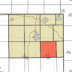 Location in Steuben County | |
| Coordinates: 41°34′13″N 84°54′40″W / 41.57028°N 84.91111°WCoordinates: 41°34′13″N 84°54′40″W / 41.57028°N 84.91111°W | |
| Country | United States |
| State | Indiana |
| County | Steuben |
| Government | |
| • Type | Indiana township |
| Area | |
| • Total | 34.78 sq mi (90.1 km2) |
| • Land | 33.54 sq mi (86.9 km2) |
| • Water | 1.24 sq mi (3.2 km2) 3.57% |
| Elevation | 958 ft (292 m) |
| Population (2010) | |
| • Total | 2,575 |
| • Density | 76.8/sq mi (29.7/km2) |
| GNIS feature ID | 453697 |
Otsego Township is one of twelve townships in Steuben County, Indiana, United States. As of the 2010 census, its population was 2,575 and it contained 1,839 housing units.[1]
Geography
According to the 2010 census, the township has a total area of 34.78 square miles (90.1 km2), of which 33.54 square miles (86.9 km2) (or 96.43%) is land and 1.24 square miles (3.2 km2) (or 3.57%) is water.[1] Lakes in this township include Ball Lake, Fee Lake, Hamilton Lake, Jackson Lake, Johnson Lake and Round Lake. The stream of Black Creek runs through this township.
Cities and towns
- Hamilton (north three-quarters)
Unincorporated towns
- Circle Park
- Clarks Landing
- Cold Springs
- Forest Park
- Fountain Park
- Island Park
- Oakwood
- Otsego Center
- Penn Park
- Ravinia Oaks
- Russels Point
(This list is based on USGS data and may include former settlements.)
Adjacent townships
- Scott Township (north)
- York Township (northeast)
- Richland Township (east)
- Troy Township, DeKalb County (southeast)
- Franklin Township, DeKalb County (south)
- Smithfield Township, DeKalb County (southwest)
- Steuben Township (west)
- Pleasant Township (northwest)
Cemeteries
The township contains five cemeteries: Carter, Hamilton, North Otsego, Otsego Center and Teegardin.
Major highways
References
- 1 2 "Population, Housing Units, Area, and Density: 2010 - County -- County Subdivision and Place -- 2010 Census Summary File 1". United States Census. Retrieved 2013-05-10.
External links
Municipalities and communities of Steuben County, Indiana, United States | ||
|---|---|---|
| City | ||
| Towns | ||
| Townships | ||
| Unincorporated communities |
| |
| Footnotes | ‡This populated place also has portions in an adjacent county or counties | |
This article is issued from Wikipedia - version of the 10/6/2016. The text is available under the Creative Commons Attribution/Share Alike but additional terms may apply for the media files.