Frystown, Pennsylvania
| Frystown, Pennsylvania | |
|---|---|
| Census-designated place | |
.jpg) | |
 Frystown | |
| Coordinates: 40°26′59″N 76°20′03″W / 40.44972°N 76.33417°WCoordinates: 40°26′59″N 76°20′03″W / 40.44972°N 76.33417°W | |
| Country | United States |
| State | Pennsylvania |
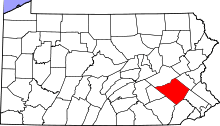
| County | Berks |
| Township | Bethel |
| Elevation | 466 ft (142 m) |
| Population (2010) | |
| • Total | 380 |
| Time zone | Eastern (EST) (UTC-5) |
| • Summer (DST) | EDT (UTC-4) |
| ZIP codes | 17067 & 19507 |
| Area code(s) | 717 Exchange: 933 |
| GNIS feature ID | 1175322[1] |
Frystown is a census-designated place[2] in Bethel Township, in far western Berks County, Pennsylvania. It is located near the township line with Tulpehocken Township. The community is served by the Tulpehocken Area School District. As of the 2010 census, the population was 380 residents.[3] The Little Swatara Creek forms the natural southern boundary of Frystown and flows westward into the Swatara Creek, a tributary of the Susquehanna River. Interstate 78 has an interchange with Route 645 in Frystown. The CDP is split between the Myerstown and Bethel post offices, which use the ZIP codes of 17067 and 19507, respectively.
References
See also
![]() Media related to Frystown, Pennsylvania at Wikimedia Commons
Media related to Frystown, Pennsylvania at Wikimedia Commons
 |
Meckville | Bethel Township | Bethel | |
| Crosskill Mills | |
Rehrersburg | ||
| ||||
| | ||||
| Greble | Myerstown | Mount Aetna |
This article is issued from Wikipedia - version of the 9/3/2016. The text is available under the Creative Commons Attribution/Share Alike but additional terms may apply for the media files.