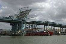
Göta älvbron
| Götaälvbron | |
|---|---|
 | |
| Coordinates | 57°42′52.3″N 11°58′1.0″E / 57.714528°N 11.966944°ECoordinates: 57°42′52.3″N 11°58′1.0″E / 57.714528°N 11.966944°E |
| Crosses | Göta älv |
| Locale | Gothenburg, Sweden |
| Characteristics | |
| Design | Bascule bridge |
| Total length | 927 m (3,041 ft)[1] |
| Width | 20 m (66 ft)[1] |
| Height | 19.5 m (64 ft)[1] |
| History | |
| Construction begin | 1937 |
| Construction end | 1939, 1966 |
| Opened | 26 November 1939 |
Götaälvbron (Göta älv Bridge) is a bascule bridge[2] in central Gothenburg, Sweden, carrying normal road vehicles and trams. The bridge was constructed in 1937 to 1939 and in 1966 it was widened. Constructed of steel beam, the bridge has a total length of 927 m (3,041 ft) and width of 20 m (66 ft). The mid span has a free height of 19.5 m (64 ft).[1]
Geography
The bridge connects the island of Hisingen with the main land of Gothenburg between Nils Ericssongatan and Hjalmar Brantningsgatan on Hisingen. The bridge crosses the river just east of Lilla Bommen on the mainland side and just east of Freeport on the Hisingen side.[3]
History
As far back as the 1870s, there were discussions about a high bridge in Majorna, from Bangatan to Skat Mountain in Lindholmen. In 1904, it was proposed to build a tunnel between the Lilla Bommen and Tingstadsvassen. After the decision that the old bridge of Hisingen would be replaced, the choice was between a new bridge or a tunnel. A principle decision was taken in 1933 on what would become a "Götaälvbro" and the question was consequently put on hold for some time. Preparatory ground works began in November 1935.
The bridge is used by motor vehicles, trams, bicycles and pedestrians. The bridge cost 8.2 million Swedish kronor (SEK) to construct, of which the state contributed 25%. With access points included the final cost were 13 million SEK.[4]
The bridge was built mainly by Germans and was inaugurated on 26 November 1939 by Communications Minister Gerhard Strindlund, in the presence of representatives of port authorities from Oslo, Copenhagen and Helsinki.[4][5] At the time, the bridge was only four-lane, but was later expanded by one lane and walking and cycle tracks on each side.
Until 1968, the heavy transit traffic went through the E6 highway, but even in 2016, the bridge is the most important connection primarily for local traffic and public transport between central Gothenburg and Hisingen even with the presence of Älvsborgsbron, Tingstadstunneln and Angeredsbron.
Future
The bridge is considered to be in a very bad condition, which leads to high costs for maintenance.[6] It is planned to replace it with a new bridge, approximately one block east.[7] The existing bridge cannot be demolished before the new has been built, because Hisingen would then lose its only tram link with the mainland.
References
- 1 2 3 4 "Götatunneln". www.ne.se. Nationalencyklopedin. Retrieved 6 January 2016.
- ↑ "Götaälvbron". Swedish Maritime Administration. Retrieved 23 April 2013.
- ↑ Göteborg, Partille och Mölndals Gatukalender, Otto Asphem, Göteborg 1979. Avsnitt "G".
- 1 2 Göteborgs kanaler och broar berättar, Bengt A. Öhnander, Tre Böcker Förlag AB, Göteborg 2007 ISBN 978-91-7029-630-7 s.80-81
- ↑ Kronologiska anteckningar om viktigare händelser i Göteborg 1619-1982, Agne Rundqvist, Ralf Scander, Anders Bothén, Elof Lindälv, utgiven av Göteborgs hembygdsförbund 1982 s. 107
- ↑ Vägverket: FAKTA Västsvenska infrastrukturpaketet
- ↑ SVT.se: Ny Götaälvbro öster om nuvarande
| Wikimedia Commons has media related to Götaälvbron. |