Garden Island, South Australia
| Garden Island South Australia | |||||||||||||
|---|---|---|---|---|---|---|---|---|---|---|---|---|---|
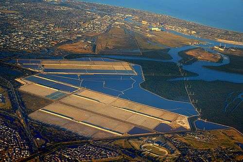 Aerial view looking WSW of part of the Port River estuary with Garden Island being located in the top right hand corner adjacent to Torrens Island | |||||||||||||
 Garden Island | |||||||||||||
| Coordinates | 34°48′26″S 138°32′04″E / 34.80717°S 138.534450°ECoordinates: 34°48′26″S 138°32′04″E / 34.80717°S 138.534450°E | ||||||||||||
| Population | 10 (shared with Torrens Island (2011 census)[1] | ||||||||||||
| Established | 2009[2] | ||||||||||||
| Postcode(s) | 5960[2] | ||||||||||||
| Time zone | ACST (UTC+9:30) | ||||||||||||
| • Summer (DST) | ACST (UTC+10:30) | ||||||||||||
| Location | 15 km (9 mi) north-west of Adelaide city centre | ||||||||||||
| LGA(s) | unincorporated area[2] | ||||||||||||
| State electorate(s) | Port Adelaide[3] | ||||||||||||
| Federal Division(s) | Port Adelaide[4] | ||||||||||||
| |||||||||||||
| |||||||||||||
| Footnotes |
Coordinates[2] Climate[5] Adjoining suburbs[2] | ||||||||||||
Garden Island is a locality in the Australian state of South Australia located in the Adelaide metropolitan area within the estuary of the Port Adelaide River about 15 kilometres (9.3 mi) north-west of the Adelaide city centre.[2][6] Its boundaries which were created in August 2009 include “the whole of the geographical feature of Garden Island” and parts of the following water bodies that adjoin the shoreline of the ‘geographic feature’ - Angas Inlet to the north, the North Arm to the south and Eastern Passage to the east.[2][7] As of 2014, the majority of the land within the locality is zoned as "MFP" which refers to the Multifunction Polis, a proposed development with the Adelaide metropolitan area to create “an international and national centre for co-operative research and innovation in science, technology, environmental management, education and the arts.”[6] Garden Island is located within the federal division of Port Adelaide and the state electoral district of Port Adelaide[4][3] Since at least 2009, Garden Island has not been located within a local government area.[2]
See also
References
- ↑ Australian Bureau of Statistics (31 October 2012). "Garden Island (SA)". 2011 Census QuickStats. Retrieved 18 March 2016.
- 1 2 3 4 5 6 7 8 "Search result for "Garden Island (Locality Bounded)" (Record no SA0047978) with the following layers selected - "Suburbs and Localities" and "Local Government Areas"". Property Location Browser. Department of Planning, Transport and Infrastructure. Retrieved 18 March 2016.
- 1 2 "District of Port Adelaide Background Profile". ELECTORAL COMMISSION SA. Retrieved 18 March 2015.
- 1 2 "Federal electorate division of Port Adelaide, boundary gazetted 16 December 2011" (PDF). Australian Electoral Commission. Retrieved 18 March 2015.
- ↑ "Monthly climate statistics: Summary statistics PARAFIELD AIRPORT (nearest station)". Commonwealth of Australia , Bureau of Meteorology. Retrieved 18 March 2016.
- 1 2 Land Not Within a Council Area (Metropolitan) Consolidated – 25 September 2014 (PDF). Department of Planning, Transport and Infrastructure (DPTI). 2014. pp. 21–22, 58–60 & 73.
- ↑ Boating Industry Association of South Australia (BIA); South Australia. Department for Environment and Heritage (2005), South Australia's waters an atlas & guide, Boating Industry Association of South Australia, p. 194, ISBN 978-1-86254-680-6