Dry Creek, South Australia
| Dry Creek Adelaide, South Australia | |||||||||||||
|---|---|---|---|---|---|---|---|---|---|---|---|---|---|
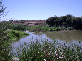 Barker Inlet wetlands at Dry Creek | |||||||||||||
| Population | 220 (2006)[1] | ||||||||||||
| Postcode(s) | 5094 | ||||||||||||
| LGA(s) |
City of Salisbury City of Port Adelaide Enfield | ||||||||||||
| State electorate(s) | Enfield | ||||||||||||
| Federal Division(s) | Port Adelaide | ||||||||||||
| |||||||||||||
| Footnotes | Adjoining suburbs[2] | ||||||||||||

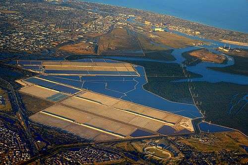
Dry Creek is a mostly industrial suburb north of Adelaide, containing significant wetlands and a substantial area formerly devoted to salt crystallisation pans, managed by Ridley Corporation, which plans to redevelop the site for housing.[3]
Description
It is named for the Dry Creek, a stream and drain which flows through the suburb and into Swan Alley, a tidal distributory of Barker Inlet, Gulf St Vincent.[2]
It was the site of the soapworks of W. H. Burford & Son from 1923 (adjacent to the Dry Creek railway station, and formerly used for smelting ore from Broken Hill)[4] and a pioneering "garden suburb" for its employees, designed by W. J. Earle (who also laid out Cadbury's model town at Claremont, Tasmania).[5] The name Burford Gardens has vanished, but its streets remain: Flame Avenue, Gum Avenue, Wattle Avenue, Grevillea Avenue and Bushwood Avenue.[6]
The buildings of the former Dry Creek explosives depot, now State heritage-listed, are on Magazine Road between the Salisbury Highway South Road Connector and the salt pans.[7]
Wetlands
The Dry Creek wetlands are composed of many separate sections running from the eastern edge of the suburb to the sea outlet of Dry Creek. They form part of the storm water management system for the City of Salisbury and the City of Port Adelaide Enfield and are connected to numerous drains that run across the Adelaide Plains including the eponymous Dry Creek, as well as being the outflow point for storm water pipes. Some of the wetlands have been extensively landscaped but have only limited public access.
The wetlands form a fauna and flora haven with one of the southern most mangrove habitats in the world, extensive reed and samphire beds and a large bird and fish population. They discharge via North Arm creek into the Barker Inlet of Gulf St Vincent. The wetlands are part of the Gulf St Vincent Important Bird Area.[8]
Transport

Dry Creek has a train station which is located on the Gawler Central railway line.
See also
References
- ↑ Australian Bureau of Statistics (25 October 2007). "Dry Creek (State Suburb)". 2006 Census QuickStats. Retrieved 28 February 2008.
- 1 2 "Search result for " Dry Creek (Suburb)" (Record no SA0020832) with the following layers selected - "Suburbs and Localities"". Property Location Browser. Government of South Australia. Retrieved 18 May 2016.
- ↑ Ridley to sell most of Dry Creek site, retain 316 hectares for residential development The Advertiser, 20 February 2014. Accessed 11 March 2015.
- ↑ A Fine New Factory The Advertiser 16 June 1920 p.9 accessed 8 July 2011
- ↑ An Old-Established BusinessThe Register 31 May 1922 p.8 accessed 4 July 2011
- ↑ Burford Gardens - Wonderful Public Enthusiasm The Mail 14 April 1923 p.1 accessed 8 July 2011
- ↑ Jolly, Bridget (13 April 2000). "High And Dry By The Mangroves? South Australia's Dry Creek Explosives Magazines" (PDF). Professional Historians Association (SA). Retrieved 10 March 2015.
- ↑ "Important Bird Areas factsheet: Gulf St Vincent". BirdLife International. 2014. Retrieved 21 October 2014.
External links
| Wikimedia Commons has media related to Dry Creek, South Australia. |
Coordinates: 34°50′S 138°35′E / 34.833°S 138.583°E