Garner, Boyd County, Kentucky
| Garner, Kentucky | |
|---|---|
| Unincorporated community | |
 Garner, Kentucky | |
| Coordinates: 38°17′41″N 82°44′09″W / 38.29472°N 82.73583°WCoordinates: 38°17′41″N 82°44′09″W / 38.29472°N 82.73583°W | |
| Country | United States |
| State | Kentucky |
| County | Boyd |
| Elevation | 640 ft (200 m) |
| Time zone | Eastern (EST) (UTC-5) |
| • Summer (DST) | EDT (UTC-4) |
| Area code(s) | 606 |
| GNIS feature ID | 508069[1] |
Garner is an unincorporated community in Boyd County, Kentucky, United States. Garner is located on Pigeon Roost Creek at the junction of Kentucky Route 854 and Kentucky Route 1945, 10.6 miles (17.1 km) southwest of Catlettsburg.[2]
References
- ↑ "Garner". Geographic Names Information System. United States Geological Survey.
- ↑ State Primary Road System: Boyd County (PDF) (Map). Kentucky Transportation Cabinet. 2010. Retrieved May 11, 2012.
Municipalities and communities of Boyd County, Kentucky, United States | ||
|---|---|---|
| Cities | 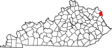 | |
| CDPs | ||
| Unincorporated communities | ||
| Ghost towns | ||
| Footnotes | ‡This populated place also has portions in an adjacent county or counties | |
This article is issued from Wikipedia - version of the 9/17/2014. The text is available under the Creative Commons Attribution/Share Alike but additional terms may apply for the media files.