Getafe, Bohol
For the city in Spain, see Getafe.
| Getafe | ||
|---|---|---|
| Municipality | ||
|
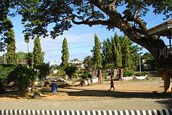
Poblacion of Getafe | ||
| ||
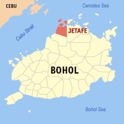
 Map of Bohol with Getafe highlighted | ||
.svg.png) Getafe Location within the Philippines | ||
| Coordinates: 10°09′N 124°09′E / 10.15°N 124.15°ECoordinates: 10°09′N 124°09′E / 10.15°N 124.15°E | ||
| Country | Philippines | |
| Region | Central Visayas (Region VII) | |
| Province | Bohol | |
| District | 2nd district of Bohol | |
| Incorporated | 1874 | |
| Barangay | 24 (see § Barangays) | |
| Government [1] | ||
| • Type | Sangguniang Bayan | |
| • Mayor | Casoy Camacho (UNA) | |
| • Vice mayor | Eduardo Torremocha | |
| • Town Council |
Members
| |
| • Representative | Erico Aristotle Aumentado | |
| Area[2] | ||
| • Total | 120.5 km2 (46.5 sq mi) | |
| Population (2015 census)[3] | ||
| • Total | 30,955 | |
| • Density | 260/km2 (670/sq mi) | |
| • Voter (2016)[4] | 18,576 | |
| Time zone | PST (UTC+8) | |
| ZIP code | 6334 | |
| IDD : area code | +63 (0)38 | |
| Income class | 3rd class | |
| PSGC | 071226000 | |
Getafe (also spelt Jetafe) is a 3rd municipal income class municipality in the province of Bohol, Philippines.[2] According to the 2015 census, it has a population of 30,955.[3] In the 2016 election, it had 18,576 registered voters.[4]
Getafe and surrounding areas suffered moderate-to-severe damage to houses, churches, and other structures in the 2013 Bohol earthquake, which caused approximately 130 fatalities in total.[5]
Barangays
Getafe comprises 24 barangays:
| PSGC | Barangay | Population | ±% p.a. | ||
|---|---|---|---|---|---|
| 2015[3] | 2010[6] | ||||
| 071226001 | Alumar | 3.8% | 1,164 | 935 | +4.26% |
| 071226002 | Banacon | 4.2% | 1,298 | 1,304 | −0.09% |
| 071226003 | Buyog | 2.9% | 906 | 775 | +3.02% |
| 071226004 | Cabasakan | 3.8% | 1,179 | 1,149 | +0.49% |
| 071226006 | Campao Occidental | 1.6% | 484 | 418 | +2.83% |
| 071226007 | Campao Oriental | 3.3% | 1,034 | 963 | +1.36% |
| 071226008 | Cangmundo | 3.1% | 972 | 968 | +0.08% |
| 071226009 | Carlos P. Garcia | 3.2% | 994 | 858 | +2.84% |
| 071226010 | Corte Baud | 2.8% | 868 | 704 | +4.07% |
| 071226011 | Handumon | 3.8% | 1,172 | 983 | +3.41% |
| 071226012 | Jagoliao | 4.4% | 1,353 | 1,478 | −1.67% |
| 071226013 | Jandayan Norte | 3.1% | 963 | 901 | +1.28% |
| 071226014 | Jandayan Sur | 5.0% | 1,538 | 1,360 | +2.37% |
| 071226015 | Mahanay (Mahanay Island) | 1.7% | 538 | 484 | +2.03% |
| 071226016 | Nasingin | 6.6% | 2,045 | 1,809 | +2.36% |
| 071226017 | Pandanon | 7.2% | 2,228 | 1,840 | +3.71% |
| 071226018 | Poblacion | 8.7% | 2,695 | 2,371 | +2.47% |
| 071226019 | Saguise | 5.3% | 1,652 | 1,358 | +3.80% |
| 071226020 | Salog | 3.9% | 1,195 | 1,036 | +2.76% |
| 071226021 | San Jose | 5.6% | 1,729 | 1,432 | +3.65% |
| 071226022 | Santo Niño | 2.5% | 768 | 686 | +2.17% |
| 071226023 | Taytay | 5.0% | 1,536 | 1,334 | +2.72% |
| 071226024 | Tugas | 2.9% | 886 | 896 | −0.21% |
| 071226025 | Tulang | 5.7% | 1,758 | 1,746 | +0.13% |
| Total | 30,955 | 27,788 | +2.08% | ||
Demographics
| Population census of Getafe | |||||||||||||||||||||||||
|---|---|---|---|---|---|---|---|---|---|---|---|---|---|---|---|---|---|---|---|---|---|---|---|---|---|
|
| ||||||||||||||||||||||||
| Source: Philippine Statistics Office[3][6][7] | |||||||||||||||||||||||||
In the 2016 election, it had 18,576 registered voters, meaning that 60% of the population are aged 18 and over.[4]
Education
-
- Campao Oriental National High School
- Handumon National High School
- Pandanon National High School
- Sto. Niño Institute
- Tulang National High School
Elementary schools[10]
-
- Alumar Elementary School
- Banacon Elementary School
- Cabasakan Elementary School
- Campao Elementary School
- Cangmundo Elementary School
- Corte Baud Elementary School
- Getafe Central Elementary School
- Handumon Elementary School
- Jagoliao Elementary School
- Jandayan Elementary School
- Mahanay Elementary School
- Nasingin Elementary School
- Pandanon Elementary School
- Saguise Elementary School
- Salog Elementary School
- San Jose Elementary School
- Taytay Elementary School
- Tugas Elementary School
- Tulang Elementary School
Private schools[11]
-
- Advent Care Multi-Grade School
- Galbreath International School
Sister cities

Roman Catholic Church, Getafe
References
- ↑ "Municipality". Quezon City, Philippines: Department of the Interior and Local Government. Retrieved 31 May 2013.
- 1 2 "Municipal: Getafe, Bohol". PSGC Interactive. Quezon City, Philippines: Philippine Statistics Authority. Retrieved 8 January 2016.
- 1 2 3 4 "Region VII (CENTRAL VISAYAS)". Census of Population (2015): Total Population by Province, City, Municipality and Barangay (Report). PSA. Retrieved 20 June 2016.
- 1 2 3 "2016 National and Local Elections Statistics". Commission on Elections. 2016.
- ↑ http://www.catholicnews.com/data/stories/cns/1304354.htm
- 1 2 "Region VII (CENTRAL VISAYAS)". Census of Population and Housing (2010): Total Population by Province, City, Municipality and Barangay (Report). NSO. Retrieved 29 June 2016.
- ↑ "Region VII (CENTRAL VISAYAS)". Census of Population (1995, 2000 and 2007): Total Population by Province, City and Municipality (Report). NSO. Archived from the original on 24 June 2011.
- ↑ "List of High Schools". DepEd - Bohol. January 1, 2015. Retrieved 5 March 2015.
- ↑ "Catholic Educational Institutions". Roman Catholic Diocese of Talibon. January 1, 2014. Retrieved 5 March 2015.
- ↑ "List of Elementary Schools". DepEd - Bohol. January 1, 2015. Retrieved 5 March 2015.
- ↑ "List and Status of Private Schools" (PDF). DepEd - Region VII. January 22, 2015. Retrieved 5 March 2015.
External links
 |
Camotes Sea |  | ||
| Cebu Strait | |
Talibon | ||
| ||||
| | ||||
| Buenavista |
This article is issued from Wikipedia - version of the 8/6/2016. The text is available under the Creative Commons Attribution/Share Alike but additional terms may apply for the media files.

