Ghana's material cultural heritage
The monuments list is taken from the Ghana Museums and Monuments Board, according to their description "legal custodian of Ghana’s material cultural heritage (movable and immovable heritage)"[1] GMMB classifies the monuments:
The ID used on this page in reference to the Regions of Ghana are based on the ISO Regional ID standards.
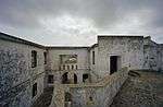
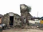
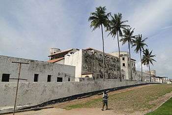
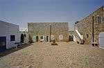
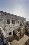
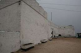
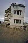
A. Western Region

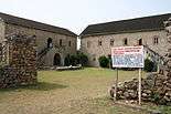
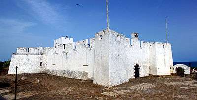


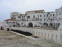
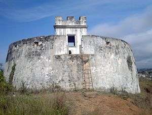
B. Central Region


.jpg)

%2C_zeezijde.jpg)
.jpg)

C. Greater Accra Region
| ID | Description | Region | Original function | Built | Location | Address | Comment | Coordinates | Image |
|---|---|---|---|---|---|---|---|---|---|
| GH-AA-001 | National Museum | Greater Accra | Museum | 1957 | Barnes Road, Accra | 5°33′24″N 0°12′28″W / 5.556667°N 0.207778°W | 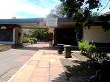 | ||
| GH-AA-002 | Museum of Science & Technology | Greater Accra | Museum | 1963 | Main Entrance of Science and Technology Museum.jpg |  | |||
| GH-AA-006 | Ussher Fort | Greater Accra | Fort | 1649 | Ussher Town, Accra | 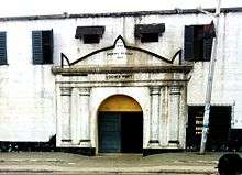 | |||
| GH-AA-007 | Ussher Fort Museum | Greater Accra | Museum | Ussher Town, Accra |  | ||||
| GH-AA-008 | James Fort | Greater Accra | Fort | 1673 | Jamestown, Accra |  | |||
| GH-AA-010 | Christiansborg Castle a.k.a. Osu Castle |
Greater Accra | Fort | 1659 | Osu, Accra | _2.jpg) | |||
| GH-AA-011 | Fort Augustaborg | Greater Accra | Fort | 1787 | Teshie |  | |||
| GH-AA-012 | Museum of Archaeology | Greater Accra | Museum | University of Ghana, Department of Archeology, Accra |  | ||||
| GH-EP-001 | Fort Vernon | Greater Accra | Fort | 1742 | Prampram | 5°43′29″N 0°07′00″E / 5.7247051°N 0.1167463°E |  | ||
| GH-EP-002 | Fort Fredensborg | Eastern | Fort | 1736 - 42 | Old Ningo | 5°45′00″N 0°11′00″E / 5.75°N 0.1833333°E | 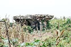 |
E. Volta Region
| ID | Description | Region | Original function | Built | Location | Address | Comment | Coordinates | Image |
|---|---|---|---|---|---|---|---|---|---|
| GH-TV-001 | Fort Prinzenstein | Volta | Fort | 1734 | Keta | 5°54′39″N 0°59′31″E / 5.910833°N 0.991944°E |  | ||
| GH-TV-002 | Volta Regional Museum | Volta | Museum | 1973 | Ho | 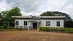 |
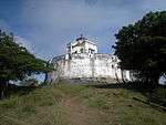
F. Ashanti Region
| ID | Description | Region | Original function | Built | Location | Address | Comment | Coordinates | Image |
|---|---|---|---|---|---|---|---|---|---|
| GH-AH-001 | Fort Kumasi | Ashanti | Fort | 1820 | Kumasi | .jpg) | |||
| GH-AH-002 | Kumasi Military Museum | Ashanti | Museum | Kumasi | 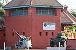 | ||||
| GH-AH-003 | Yaw Tano Shrine a.k.a. Tano Yaw Shrine |
Ashanti | Shrine | Ejisu-Besease | at Besease, about 20.8 km on the Kumasi-Accra road. | 5°33′26″N 1°11′45″W / 5.5572433°N 1.1959147°W | 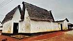 | ||
| GH-AH-004 | Akwasi Sima Shrine a.k.a. Kwasi Kuma Shrine |
Ashanti | Shrine | Adarkwa Jachie | about 16 km on the Kumasi-Ejisu road. | 
| |||
| GH-AH-005 | Tano Abenamu Subunu Shrine | Ashanti | Shrine | Abirem | Abirem is about 12.8 km from Kumasi on the Antoa Road, Coord of Antoa Road | 6°42′30″N 1°36′20″W / 6.7082007°N 1.605463°W |  | ||
| GH-AH-006 | Tano Kwadwo Shrine | Ashanti | Shrine | Saaman | Saaman is about 12.6 km north-east of Kumasi, on the former Odumakoma Tempong road that led toNorthern Ghana. | 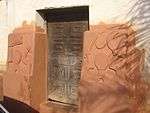 | |||
| GH-AH-007 | Atuo Kosua Shrine | Ashanti | Shrine | Adwinase | off the Ejisu-Onwi road. | 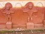 | |||
| GH-AH-008 | Kentinkrono Shrine | Ashanti | Shrine | Kentinkrono | At Kentinkrono, about 20.8km on the Kumasi-Ejisu road. |  | |||
| GH-AH-009 | Tano Odomankoma Shrine | Ashanti | Shrine | Bogwiase | foot of the rocky Mampong scarp, about 10 km from Effiduase, in theSekyere West District. |
| |||
| GH-AH-010 | Asawase Shrine a.k.a. Tano Banie Shrine |
Ashanti | Shrine | Asawase near Ejisu | to the south of Ejisu, about 10 km on the second-class road linking Ejisu and Apromase. |
| |||
| GH-AH-011 | Asenemaso Shrine | Ashanti | Shrine | Asenemaso | Kumasi-Sunyani road, at a distance of about 15 km from Kejetia. | |
G. Northern Region
| ID | Description | Region | Original function | Built | Location | Address | Comment | Coordinates | Image |
|---|---|---|---|---|---|---|---|---|---|
| GH-NP-001 | Larabanga Mosque | Northern Region | Mosque | 14th Century | 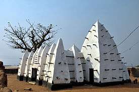 |
Upper East
| ID | Description | Region | Original function | Built | Location | Address | Comment | Coordinates | Image |
|---|---|---|---|---|---|---|---|---|---|
| GH-UE-001 | Upper East Regional Museum | Upper East | Museum | Bolgatanga | 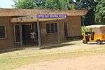 |
Archeological Sites
It is not clear what to do with the.[3] It is listed on the QMMB site, and contains information about:
References
This article is issued from Wikipedia - version of the 11/6/2016. The text is available under the Creative Commons Attribution/Share Alike but additional terms may apply for the media files.