Apam
| Apam Apaa (pronounced Are-paahn) | |
|---|---|
| Town and District Capital | |
|
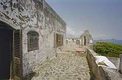
Fort Lijdzaamheid or Fort Patience in Apam | |
 Apam Location of Apam in Central Region | |
| Coordinates: 5°16′44″N 0°44′23″W / 5.27889°N 0.73972°WCoordinates: 5°16′44″N 0°44′23″W / 5.27889°N 0.73972°W | |
| Country |
|
| Region |
|
| District | Gomoa West District |
| Population (2013) | |
| • Total | 26,466[1] |
| Time zone | Greenwich Mean Time |
| • Summer (DST) | GMT (UTC) |
Apam is a Coastal town and capital of Gomoa West District in the Central Region of Ghana, located approximately 45 km east of the Central regional capital of Cape Coast.
Apam is the site of Fort Lijdzaamheid or Fort Patience, a Dutch-built Fort which was completed in 1702, which dominates the fishing harbor and town from a rocky peninsula located on the south side of the town. It used to be a major port in pre-independence times but after Tema was built shipping was forbidden. The town has an Odikro (Chief of the town). It is also a major town in the Gomoa Akyempem Paramountcy. It has a lot of fishermen as fishing is the main industry. Apam has a secondary school, an FM station, several churches and a salt winning industry. The Benyah Lagoon is used for producing salt. Apam
References
- ↑ "World Gazetteer online". World-gazetteer.com.
External links
| Wikivoyage has a travel guide for Apam. |
![]() Media related to Apam (Ghana) at Wikimedia Commons
Media related to Apam (Ghana) at Wikimedia Commons
District capitals in Ghana | |
|---|---|
| Ashanti Region | |
| Brong-Ahafo Region | |
| Central Region | |
| Eastern Region | |
| Greater Accra Region | |
| Northern Region | |
| Upper East Region | |
| Upper West Region | |
| Volta Region | |
| Western Region | |
Regional capitals in bold
| |