Glide, Oregon
| Glide, Oregon | |
|---|---|
| Census-designated place (CDP) | |
 | |
 Location of Glide, Oregon | |
| Coordinates: 43°19′9″N 123°4′1″W / 43.31917°N 123.06694°WCoordinates: 43°19′9″N 123°4′1″W / 43.31917°N 123.06694°W | |
| Country | United States |
| State | Oregon |
| County | Douglas |
| Area | |
| • Total | 10.2 sq mi (26.3 km2) |
| • Land | 10.1 sq mi (26.2 km2) |
| • Water | 0.1 sq mi (0.2 km2) |
| Elevation | 689 ft (210 m) |
| Population (2010) | |
| • Total | 1,795 |
| • Density | 180/sq mi (68/km2) |
| Time zone | Pacific (PST) (UTC-8) |
| • Summer (DST) | PDT (UTC-7) |
| ZIP code | 97443 |
| Area code(s) | 541 |
| FIPS code | 41-29750[1] |
| GNIS feature ID | 1121168[2] |
Glide is a census-designated place (CDP) in Douglas County, Oregon, United States. The population was 1,795 at the 2010 census.[3]
Geography
According to the United States Census Bureau, the CDP has a total area of 10.2 square miles (26 km2), of which 10.1 square miles (26 km2) is land and 0.1 square miles (0.26 km2), or 0.59%, is water.
Climate
| Climate data for Glide, Oregon | |||||||||||||
|---|---|---|---|---|---|---|---|---|---|---|---|---|---|
| Month | Jan | Feb | Mar | Apr | May | Jun | Jul | Aug | Sep | Oct | Nov | Dec | Year |
| Record high °F (°C) | 70 (21) |
77 (25) |
80 (27) |
90 (32) |
97 (36) |
101 (38) |
103 (39) |
104 (40) |
102 (39) |
96 (36) |
76 (24) |
66 (19) |
104 (40) |
| Average high °F (°C) | 46 (8) |
52 (11) |
57 (14) |
63 (17) |
70 (21) |
75 (24) |
84 (29) |
84 (29) |
78 (26) |
64 (18) |
51 (11) |
44 (7) |
64 (17.9) |
| Average low °F (°C) | 34 (1) |
34 (1) |
36 (2) |
38 (3) |
43 (6) |
47 (8) |
50 (10) |
49 (9) |
45 (7) |
41 (5) |
37 (3) |
33 (1) |
40.6 (4.7) |
| Record low °F (°C) | 2 (−17) |
6 (−14) |
16 (−9) |
24 (−4) |
26 (−3) |
31 (−1) |
34 (1) |
32 (0) |
26 (−3) |
19 (−7) |
13 (−11) |
−1 (−18) |
−1 (−18) |
| Average precipitation inches (mm) | 8.72 (221.5) |
6.74 (171.2) |
6.62 (168.1) |
5.40 (137.2) |
3.71 (94.2) |
1.96 (49.8) |
0.70 (17.8) |
0.72 (18.3) |
1.77 (45) |
4.63 (117.6) |
10.01 (254.3) |
10.90 (276.9) |
61.88 (1,571.9) |
| Source: [4] | |||||||||||||
Demographics
As of the census[1] of 2000, there were 1,690 people, 624 households, and 484 families residing in the CDP. The population density was 167.3 people per square mile (64.6/km²). There were 675 housing units at an average density of 66.8 per square mile (25.8/km²). The racial makeup of the CDP was 94.73% White, 2.31% Native American, 0.47% Asian, 0.12% Pacific Islander, 0.06% from other races, and 2.31% from two or more races. Hispanic or Latino of any race were 0.95% of the population.
There were 624 households out of which 36.1% had children under the age of 18 living with them, 65.9% were married couples living together, 7.4% had a female householder with no husband present, and 22.4% were non-families. 18.1% of all households were made up of individuals and 6.9% had someone living alone who was 65 years of age or older. The average household size was 2.71 and the average family size was 3.06.
In the CDP the population was spread out with 28.6% under the age of 18, 6.2% from 18 to 24, 25.4% from 25 to 44, 27.7% from 45 to 64, and 12.2% who were 65 years of age or older. The median age was 39 years. For every 100 females there were 104.1 males. For every 100 females age 18 and over, there were 100.5 males.
The median income for a household in the CDP was $40,345, and the median income for a family was $45,313. Males had a median income of $37,857 versus $21,591 for females. The per capita income for the CDP was $18,444. About 9.4% of families and 8.0% of the population were below the poverty line, including 13.2% of those under age 18 and 8.0% of those age 65 or over.
Points of interest
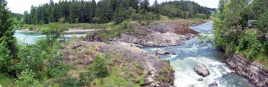
- Colliding Rivers: the North Umpqua River and the Little River meet head-on, the only place in the world where this happens.[5]
See also
References
- 1 2 "American FactFinder". United States Census Bureau. Retrieved 2008-01-31.
- ↑ "US Board on Geographic Names". United States Geological Survey. 2007-10-25. Retrieved 2008-01-31.
- ↑ "Profile of General Population and Housing Characteristics: 2010 Demographic Profile Data (DP-1): Glide CDP, Oregon". U.S. Census Bureau, American Factfinder. Retrieved February 13, 2012.
- ↑ "Monthly Averages for Glide, OR (97443)". Weather.com. Retrieved March 5, 2012.
- ↑ Byways.org website
Municipalities and communities of Douglas County, Oregon, United States | ||
|---|---|---|
| Cities | 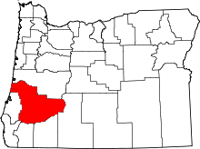 | |
| CDPs | ||
| Unincorporated communities | ||