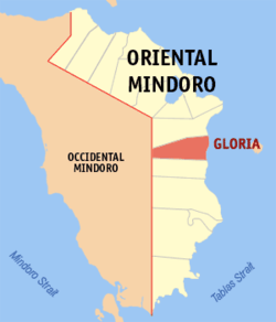
Gloria, Oriental Mindoro
| Gloria | |
|---|---|
| Municipality | |
 Map of Oriental Mindoro showing the location of Gloria | |
.svg.png) Gloria Location within the Philippines | |
| Coordinates: 12°55′N 121°28′E / 12.917°N 121.467°ECoordinates: 12°55′N 121°28′E / 12.917°N 121.467°E | |
| Country | Philippines |
| Region | MIMAROPA (Region IV-B) |
| Province | Oriental Mindoro |
| District | 2nd District of Oriental Mindoro |
| Founded | October 1, 1964 |
| Barangays | 27 |
| Government[1] | |
| • Mayor | German D. Rodegerio |
| Area[2] | |
| • Total | 245.52 km2 (94.80 sq mi) |
| Population (2010)[3] | |
| • Total | 42,012 |
| • Density | 170/km2 (440/sq mi) |
| Time zone | PST (UTC+8) |
| ZIP code | 5209 |
| Dialing code | 43 |
| Income class | 3rd class; partially urban |
| Website |
www |
Gloria (formerly Maligaya) is a third-class municipality in the province of Oriental Mindoro, Philippines. According to the 2010 census, it has a population of 42,012 people.[3]
The town was previously a barangay called Maligaya, the largest barangay during the administration of President Diosdado Macapagal. Local politicians, led by former guerrilla chief Nicolas Jamilla, Sr., battled for the conversion of Maligaya into a new town. They renamed it after the ten-year-old daughter of the President, Gloria Macapagal Arroyo, who later on herself became the fourteenth President in 2001. Jamilla became the first mayor of the town, which kept the old name "Maligaya" as the name of a barangay in the poblacion.
Barangays
Gloria is divided into 27 barangays:[2] nine (9) barangays are situated along the national highway; six (6) are coastal barangays; and twelve (12) interior barangays on the west side.[4]
- Agsalin -------------------------- 678
- Agos ----------------------------- 1,036
- Alma Villa ----------------------- 1,411
- Andres Bonifacio ----------------- 1,320
- Balete --------------------------- 2,864
- Banus ---------------------------- 2,298
- Banutan -------------------------- 906
- Buong Lupa ----------------------- 969
- Bulaklakan ----------------------- 1,126
- Gaudencio Antonino (Tinalunan) --- 1,651
- Guimbonan ------------------------ 1,104
- Kawit ---------------------------- 2,022
- Lucio Laurel (Kalamundingan) ----- 2,649
- Macario Adriatico (Tubag) -------- 1,139
- Malamig -------------------------- 2,929
- Malayong ------------------------- 1,228
- Maligaya (Poblacion) ------------- 3,246
- Malubay -------------------------- 1,319
- Manguyang ------------------------ 1,633
- Maragooc ------------------------- 1,258
- Mirayan -------------------------- 938
- Narra (Malusak) ------------------ 2,169
- Papandungin --------------------- 1,110
- San Antonio (Dalagan) ------------ 1,330
- Sta. Maria (Bulbugan) ------------ 2,034
- Santa Theresa (Langgang) --------- 1,523
- Tambong -------------------------- 3,183
History
Gloria was once part of the municipality of Pinamalayan. In 1915, migrant families from Marinduque settled in Barrio Tambong, and in 1930, when a national road was built through Pinamalayan, they moved west and occupied the area along this road. Tambong was later divided into two barrios: the first retained the original name, while the second was called Maligaya (meaning "happy"), alluding to the settlers' happiness at the bountiful yield of their agricultural crops.[5]
The residents of 25 barrios (Maligaya, Kawit, Malusak, Balite, Dalagan, Tinalunan, Calamundingan, Bulbogan, Langang, Banus, Agus, Batingan, Papandungin, Malamig, Tubag, Malayong, Malubay, Mirayan, Guimbonan, Agsalin, Manguyang, Banutan, Boong-Lupa, Tambong and Maragooc) grouped together and petitioned for the separation of their barrios from the municipality of Pinamalayan. The petition was granted on October 1, 1964, through Executive Order No. 117 issued by President Diosdado Macapagal. Executive Order No. 140, issued on February 25, 1965, by the same President, defined and fixed the boundaries of Gloria as a new municipality. On December 24, 1965, however, the Supreme Court nullified its status as a municipality. Gloria was finally recognized as a distinct municipality on June 9, 1966, when Housebill No. 6107, sponsored by Congressman Luciano Joson, was enacted into law. (It later became known as RA 4651.)[5]
The new municipality was named Gloria, primarily as a token of gratitude to President Macapagal, whose daughter is named Gloria, and secondarily from the word "glory", celebrating the settlers' "glorious" life in Barrio Maligaya.
Barrio Maligaya later became the poblacion and the official seat of the municipal government. Nicolas M. Jamilla Sr. was appointed first Mayor of Gloria by President Diosdado Macapagal, serving from 1964 to 1967. He then ran in the local election of 1967 and won. The first session of the Municipal Council was held in the residence of Mr. Albino Janda. The town's official functions were held in this house from February 1964 to November 1965; then in the residences of Genaro Olavidez from March to June 1965 and Arsenio Arriola from July 1965 to 1973.[5]
The name of the following barangays were changed: Bulbugan to Santa Maria; Dalagan to San Antonio; Malusak to Narra; Batingan to A. Bonifacio; Tubag to Macario Adriatico; Tinalunan to Gaudencio Antonino; Langang to Santa Theresa and Calamundingan to Lucio Laurel. The new barangays of Bulaklakan and Alma Villa were created later. In 1968, Gloria Realty Development Corporation donated two hectares to the municipality, and this became the site of the Municipal Building in 1972. Under the leadership of Mayor Jamilla, the municipality later bought a ten-hectare lot, which became the site of the Municipal Cemetery, Sports Center, Agricultural Center and Breeding Station, and the Medicare Hospital.[5]
Demographics
| Population census of Gloria | ||
|---|---|---|
| Year | Pop. | ±% p.a. |
| 1990 | 30,102 | — |
| 1995 | 35,771 | +3.29% |
| 2000 | 38,667 | +1.68% |
| 2007 | 40,561 | +0.66% |
| 2010 | 42,012 | +1.29% |
| Source: National Statistics Office[3] | ||
List of former mayors
- Nicolas M. Jamilla, Sr. (1964–1986; 1988–1995)+
- Amando Medrano (1986–1987)+
- Felix V. Jarabe (1987)+
- Alonzo San Agustin (1987–1988)+
- Jimmy S. de Castro (1995–2001)
- Romeo D. Álvarez (2001–2010)+
- Loreto S. Pérez (2010– incumbent)
Education
Tertiary
- Erhard Science and Technological Institute
Secondary
- President Diosdado Macapagal Memorial National High School (formerly known as Malamig National High School Extension)
- Malamig National High School
- Manuel Adriano Memorial National High School
- Bulbugan National High School
- Sacred Heart Academy
- Oriental Mindoro Institute
Elementary Schools
- Melicio D. Cantos Memorial Elementary School
- Tinalunan Elementary School
- Don Joaquin Roque Memorial Elementary School (formerly known as Calamundingan Elementary School)
- Langgang Elementary School
- Manuel Sadiwa Memorial Elementary School
- Bulbugan Elementary School
- Manguyang Elementary School
- Banutan Elementary School
- Banus Elementary School
- Malayong Elementary School
- Balete Elementary School
- Papandungin Elementary School
- Malusak Elementary School
- Dalagan Elementary School
- Batingan Elementary School
- Malamig Elementary School
- Gloria Central School
- A. Bonifacio Elementary School
- Agos Elementary School
- Tambong Elementary School
- Sacred Heart Academy Elementary Department
- Buong-Lupa Elementary School
Tourist Spots
- Bighani Beach Resort
- Bali Beach Garden Resort and SPA
- Villa Concepcion Inland Resort
- Dupong Freshwater Resort
- Walanglangit Waterfalls
- Mt. Manguyang Camping Site
- Bulaklakan Tree Farm
Events
- February 14–15: Town Fiesta in honor fn the Sacred Heart of Jesus
- September 29 to October 1: Kawayanan Festival
- October 1: Foundation Day
References
- ↑ "Official City/Municipal 2013 Election Results". Intramuros, Manila, Philippines: Commission on Elections (COMELEC). 11 September 2013. Retrieved 23 December 2013.
- 1 2 "Province: ORIENTAL MINDORO". PSGC Interactive. Makati City, Philippines: National Statistical Coordination Board. Retrieved 30 October 2012.
- 1 2 3 "Total Population by Province, City, Municipality and Barangay: as of May 1, 2010" (PDF). 2010 Census of Population and Housing. National Statistics Office. Retrieved 30 October 2012.
- ↑ "Brief Introduction about the Municipality of Gloria". Municipality of Gloria. Retrieved 30 October 2012.
- 1 2 3 4 "History and Roll of Honors". Profile :: About the Municipality. Municipality of Gloria. 30 September 2010. Retrieved 30 October 2012.
External links
- Philippine Standard Geographic Code
- Philippine Census Information
- Local Governance Performance Management System
- Official Website of the Municipality of Gloria
 |
Pinamalayan | | ||
| Sablayan, Occidental Mindoro | |
Sibuyan Sea / Concepcion, Romblon | ||
| ||||
| | ||||
| Bansud |
Calapan (capital) | |
| Municipalities | |
| Component city | |