Godley East railway station
| Godley East | |
|---|---|
 | |
| Location | |
| Place | Godley, Greater Manchester |
| Area | Tameside |
| Grid reference | SJ968946 |
| Operations | |
| Original company |
Sheffield, Ashton-under-Lyne and Manchester Railway (1st sta) Manchester, Sheffield and Lincolnshire Railway (2nd sta) |
| Pre-grouping | Great Central Railway |
| Post-grouping | London and North Eastern Railway |
| Platforms | 4 |
| History | |
| 17 November 1841 | 1st station opened as Godley Toll Bar |
| 11 December 1842 | Closed |
| 1 February 1866 | 2nd station opened as Godley Junction |
| 6 May 1974 | Renamed Godley |
| 7 July 1986 | Renamed Godley East |
| 27 May 1995 | Closed |
| Disused railway stations in the United Kingdom | |
|
Closed railway stations in Britain A B C D–F G H–J K–L M–O P–R S T–V W–Z | |
|
| |
Godley East was a railway station in the Godley area of Hyde, Tameside, Greater Manchester, on the Manchester–Glossop Line.
Early history
Godley was the temporary terminus of the route to Sheffield when the first section of the Woodhead Line was opened on 17 November 1841, but the original station was located about ¼ mile further west. This temporary station was named Godley Toll Bar and closed on 11 December 1842 when the line was extended to Broadbottom.
Godley East once had four platforms, two on the Manchester–Glossop Line and two linking the Woodhead Line with the Cheshire Lines Committee (CLC) route to Apethorne Junction (Woodley). The branch opened in 1866, after which Godley became known as Godley Junction.[1] The CLC platforms were only ever lightly used. The station and sidings were controlled by a single mechanical signal box which was located at the east end of the 'up' (Hadfield) platform.
Electrification
The electrification of the Woodhead line in 1954 gave Godley a strategic importance that it retained until the through route to Sheffield closed in 1981. Godley was one of the locations where trains to and from the Liverpool district changed from diesel or steam to electric traction, and vice versa. In steam days there was a large turntable situated on the CLC branch. The turntable pit is still in existence and remains in remarkably good condition and free of debris.[2] The line to Woodley was essentially made redundant by the closure of the Woodhead route & traffic over it finally ceased in 1982; track lifting followed in 1985/6 and it has now been taken over by Sustrans and converted into a cycle path.
The station was renamed from Godley Junction to Godley on 6 May 1974.[3]
Closure
On 7 July 1986, a new station called Godley was opened on the site of the original Godley Toll Bar station,[4] and the original station was renamed Godley East. With the addition of Hattersley serving more closely the nearby council estate, train services were gradually reduced and the station formally closed on 27 May 1995.[5]
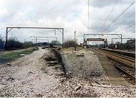
The main platforms remain intact in 2015, although now largely overgrown. The platforms on the Hadfield line are fenced off; however from the now cycle track which runs along the former line linking to Woodley & Stockport, the remains of the other platforms are visible. The derelict footbridge was removed during the late 2000s.

References
- ↑ R.P.Griffiths (1978). The Cheshire Lines Railway. The Oakwood Press. p. 52. ISBN 978-0-85361-085-4.
- ↑ "Godley Junction turntable pit England, Gerald, Geograph.org; Retrieved 15 November 2016
- ↑ Slater, J.N., ed. (July 1974). "Notes and News: Stations renamed by LMR". Railway Magazine. London: IPC Transport Press Ltd. 120 (879): 363. ISSN 0033-8923.
- ↑ Alan Bevan, ed. (1998). A—Z of Rail Reopenings. Railway Development Society. Warwick: Warwick Printing Company. p. 43. ISBN 0-901283-13-4.
- ↑ "List of dates from 1 January 1985 to 20 January 2006 of last passenger trains at closed BR (or Network Rail stations since privatisation)" (PDF). Department for Transport Website: Freedom of Information Act responses, February 2006. Department for Transport. 2006. Archived from the original (PDF) on 12 May 2009. Retrieved 5 December 2014.
Coordinates: 53°26′55″N 2°02′58″W / 53.4486°N 2.0495°W