Dean Lane railway station
| Dean Lane | |
|---|---|
 | |
| Location | |
| Place | Newton Heath |
| Area | Manchester |
| Operations | |
| Pre-grouping | Northern |
| Platforms | 2 |
| Annual rail passenger usage | |
| 2004/05 * | 26,132 |
| 2005/06 * |
|
| 2006/07 * |
|
| 2007/08 * |
|
| 2008/09 * |
|
| History | |
| 17 May 1880 | Opened |
| 3 October 2009 | Closed for Metrolink conversion |
| 13 June 2012 | Re-opened as Newton Heath and Moston Metrolink station |
| Disused railway stations in the United Kingdom | |
| * Annual passenger usage based on sales of tickets in stated financial year(s) which end or originate at Dean Lane from Office of Rail Regulation statistics. Please note: methodology may vary year on year. | |
|
Closed railway stations in Britain A B C D–F G H–J K–L M–O P–R S T–V W–Z | |
|
| |
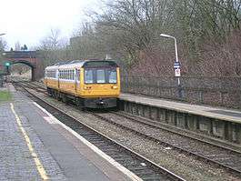
Dean Lane railway station opened on 17 May 1880[1] and served Newton Heath, Manchester, England. The station was on the Oldham Loop Line 2 1⁄2 miles (4.0 km) north east of Manchester Victoria and was operated and managed by Northern. There were once three stations in Newton Heath: Newton Heath, Dean Lane and Park. The station was 200 yards (180 m) away from the Newton Heath Train Maintenance Depot.
The station closed for conversion to Metrolink on 3 October 2009 and re-opened as Newton Heath and Moston Metrolink station on 13 June 2012, using only the former Manchester-bound platform. The track has been singled through the station, allowing Network Rail to use the other line to access the Greater Manchester Waste Disposal facility.[1]
References
- 1 2 "Dean Lane". Disused Stations: Closed Stations in the UK. Retrieved 2012-06-22.
Bibliography
Butt, R.V.J "The Directory of Railway Stations", Patrick Stephens, Sparkford, 1995, ISBN 1-85260-508-1
External links
| Manchester Lines | |||||||||||||||||||||||||||||||||||||||||||||||||||||||||||||||||||||||||||||||||||||||||||||||||||||||||||||||||||||||||||||||||||||||||||||||||||||||||||||||||||||||||||||||||||||||||||||||||||||||||||||||||||||||||||||||||||||||||||||||||||||||||||||||||||||||||||||||||||||||||||||||||||||||||||||||||||||||||||||||||||||||||||||||||||||||||||||||||||||||||||||||||||||||||||||||||||||||||||||||||||||||||||||
|---|---|---|---|---|---|---|---|---|---|---|---|---|---|---|---|---|---|---|---|---|---|---|---|---|---|---|---|---|---|---|---|---|---|---|---|---|---|---|---|---|---|---|---|---|---|---|---|---|---|---|---|---|---|---|---|---|---|---|---|---|---|---|---|---|---|---|---|---|---|---|---|---|---|---|---|---|---|---|---|---|---|---|---|---|---|---|---|---|---|---|---|---|---|---|---|---|---|---|---|---|---|---|---|---|---|---|---|---|---|---|---|---|---|---|---|---|---|---|---|---|---|---|---|---|---|---|---|---|---|---|---|---|---|---|---|---|---|---|---|---|---|---|---|---|---|---|---|---|---|---|---|---|---|---|---|---|---|---|---|---|---|---|---|---|---|---|---|---|---|---|---|---|---|---|---|---|---|---|---|---|---|---|---|---|---|---|---|---|---|---|---|---|---|---|---|---|---|---|---|---|---|---|---|---|---|---|---|---|---|---|---|---|---|---|---|---|---|---|---|---|---|---|---|---|---|---|---|---|---|---|---|---|---|---|---|---|---|---|---|---|---|---|---|---|---|---|---|---|---|---|---|---|---|---|---|---|---|---|---|---|---|---|---|---|---|---|---|---|---|---|---|---|---|---|---|---|---|---|---|---|---|---|---|---|---|---|---|---|---|---|---|---|---|---|---|---|---|---|---|---|---|---|---|---|---|---|---|---|---|---|---|---|---|---|---|---|---|---|---|---|---|---|---|---|---|---|---|---|---|---|---|---|---|---|---|---|---|---|---|---|---|---|---|---|---|---|---|---|---|---|---|---|---|---|---|---|---|---|---|---|---|---|---|---|---|---|---|---|---|---|---|---|---|---|---|---|---|---|---|---|---|---|---|---|---|---|---|---|---|---|---|---|---|---|---|---|---|---|---|---|---|---|---|---|---|---|---|---|---|---|---|---|---|
Legend | |||||||||||||||||||||||||||||||||||||||||||||||||||||||||||||||||||||||||||||||||||||||||||||||||||||||||||||||||||||||||||||||||||||||||||||||||||||||||||||||||||||||||||||||||||||||||||||||||||||||||||||||||||||||||||||||||||||||||||||||||||||||||||||||||||||||||||||||||||||||||||||||||||||||||||||||||||||||||||||||||||||||||||||||||||||||||||||||||||||||||||||||||||||||||||||||||||||||||||||||||||||||||||||
| |||||||||||||||||||||||||||||||||||||||||||||||||||||||||||||||||||||||||||||||||||||||||||||||||||||||||||||||||||||||||||||||||||||||||||||||||||||||||||||||||||||||||||||||||||||||||||||||||||||||||||||||||||||||||||||||||||||||||||||||||||||||||||||||||||||||||||||||||||||||||||||||||||||||||||||||||||||||||||||||||||||||||||||||||||||||||||||||||||||||||||||||||||||||||||||||||||||||||||||||||||||||||||||
| The Oldham Loop Line |
|---|
| Stations (anticlockwise from Manchester) (*) Closed 3 October 2009 Dean Lane (*) |
| Preceding station | Historical railways | Following station | ||
|---|---|---|---|---|
| Miles Platting | L&YR Oldham Loop Line |
Failsworth | ||
| Tram stops |   | |||||||||||||||||||||||||||||||
|---|---|---|---|---|---|---|---|---|---|---|---|---|---|---|---|---|---|---|---|---|---|---|---|---|---|---|---|---|---|---|---|---|
| Operations |
| |||||||||||||||||||||||||||||||
| History (Timeline) |
| |||||||||||||||||||||||||||||||
| Proposed stops |
| |||||||||||||||||||||||||||||||
Coordinates: 53°30′15″N 2°11′3″W / 53.50417°N 2.18417°W