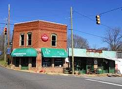
Goodwater, Alabama
| Goodwater, Alabama | |
|---|---|
| Town | |
 | |
 Location in Coosa County and the state of Alabama | |
| Coordinates: 33°3′35″N 86°3′10″W / 33.05972°N 86.05278°WCoordinates: 33°3′35″N 86°3′10″W / 33.05972°N 86.05278°W | |
| Country | United States |
| State | Alabama |
| County | Coosa |
| Area | |
| • Total | 6.53 sq mi (16.90 km2) |
| • Land | 6.49 sq mi (16.82 km2) |
| • Water | 0.03 sq mi (0.08 km2) |
| Elevation | 840 ft (256 m) |
| Population (2010) | |
| • Total | 1,475 |
| • Density | 227/sq mi (87.7/km2) |
| Time zone | Central (CST) (UTC-6) |
| • Summer (DST) | CDT (UTC-5) |
| ZIP code | 35072 |
| Area code(s) | 256 |
| FIPS code | 01-30640 |
| GNIS feature ID | 0159683 |
Goodwater is a town in Coosa County, Alabama, United States. At the 2010 census the population was 1,475.[1] It is part of the Talladega-Sylacauga Micropolitan Statistical Area.
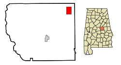
Geography
Goodwater is located near the northeast corner of Coosa County at 33°03′36″N 86°03′11″W / 33.059988°N 86.053043°W.[2]
According to the U.S. Census Bureau, the city has a total area of 6.5 square miles (16.9 km2), of which 0.03 square miles (0.08 km2), or 0.45%, is water.[1]
Demographics
| Historical population | |||
|---|---|---|---|
| Census | Pop. | %± | |
| 1890 | 589 | — | |
| 1900 | 728 | 23.6% | |
| 1910 | 740 | 1.6% | |
| 1920 | 920 | 24.3% | |
| 1930 | 996 | 8.3% | |
| 1940 | 1,028 | 3.2% | |
| 1950 | 1,227 | 19.4% | |
| 1960 | 2,023 | 64.9% | |
| 1970 | 2,172 | 7.4% | |
| 1980 | 1,895 | −12.8% | |
| 1990 | 1,840 | −2.9% | |
| 2000 | 1,633 | −11.2% | |
| 2010 | 1,475 | −9.7% | |
| Est. 2015 | 1,343 | [3] | −8.9% |
| U.S. Decennial Census[4] 2013 Estimate[5] | |||
As of the census[6] of 2000, there were 1,633 people, 621 households, and 424 families residing in the city. The population density was 249.6 people per square mile (96.4/km²). There were 727 housing units at an average density of 111.1 per square mile (42.9/km²). The racial makeup of the city was 73.30% Black or African American, 25.66% White, 0.31% Native American, 0.12% Asian, 0.06% from other races, and 0.55% from two or more races. 0.55% of the population were Hispanic or Latino of any race.
In the city the population was spread out with 25.3% under the age of 18, 8.3% from 18 to 24, 25.3% from 25 to 44, 23.4% from 45 to 64, and 17.8% who were 65 years of age or older. The median age was 38 years. For every 100 females there were 87.5 males. For every 100 females age 18 and over, there were 80.7 males.
The median income for a household in the city was $22,188, and the median income for a family was $28,819. Males had a median income of $22,414 versus $17,464 for females. The per capita income for the city was $10,602. About 21.0% of families and 23.3% of the population were below the poverty line, including 33.8% of those under age 18 and 12.0% of those age 65 or over.
2010 census
As of the census[7] of 2010, there were 1,475 people, 618 households, and 394 families residing in the city. The population density was 227 people per square mile (87.7/km²). There were 708 housing units at an average density of 108.4 per square mile (41.9/km²). The racial makeup of the city was 73.7% Black or African American, 24.3% White, 0.7% Native American, 0.0% Asian, 0.7% from other races, and 0.5% from two or more races. 0.7% of the population were Hispanic or Latino of any race.
In the city the population was spread out with 22.2% under the age of 18, 6.8% from 18 to 24, 22.9% from 25 to 44, 28.3% from 45 to 64, and 19.7% who were 65 years of age or older. The median age was 43.6 years. For every 100 females there were 88.1 males. For every 100 females age 18 and over, there were 90.4 males.
The median income for a household in the city was $24,909, and the median income for a family was $31,081. Males had a median income of $24,554 versus $24,348 for females. The per capita income for the city was $12,957. About 23.6% of families and 28.2% of the population were below the poverty line, including 48.2% of those under age 18 and 18.3% of those age 65 or over.
Notable people
- Robert Daniel Carmichael, mathematician for whom Carmichael numbers are named[8]
- Colonel Hartley A. Moon, adjutant general of Alabama
- Jamario Moon, professional basketball player
References
- 1 2 "Geographic Identifiers: 2010 Demographic Profile Data (G001): Goodwater town, Alabama". U.S. Census Bureau, American Factfinder. Retrieved June 9, 2014.
- ↑ "US Gazetteer files: 2010, 2000, and 1990". United States Census Bureau. 2011-02-12. Retrieved 2011-04-23.
- ↑ "Annual Estimates of the Resident Population for Incorporated Places: April 1, 2010 to July 1, 2015". Retrieved July 2, 2016.
- ↑ "U.S. Decennial Census". Census.gov. Retrieved June 6, 2013.
- ↑ "Annual Estimates of the Resident Population: April 1, 2010 to July 1, 2013". Retrieved June 3, 2014.
- ↑ "American FactFinder". United States Census Bureau. Retrieved 2008-01-31.
- ↑ "American FactFinder". United States Census Bureau. Retrieved 2015-07-19.
- ↑ Thomas Koshy (8 May 2007). Elementary Number Theory with Applications. Academic Press. p. 339. ISBN 978-0-08-054709-1.
External links
Municipalities and communities of Coosa County, Alabama, United States | ||
|---|---|---|
| Towns | 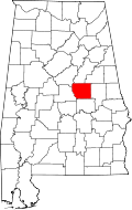 | |
| CDPs | ||
| Unincorporated communities | ||
| Footnotes | ‡This populated place also has portions in an adjacent county or counties | |