Goshen, Alabama
| Goshen, Alabama | |
|---|---|
| Town | |
|
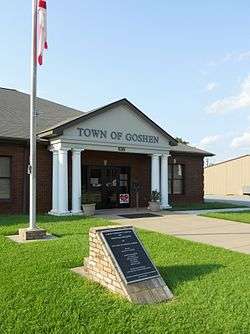
The new community center and town hall building in Goshen, Alabama | |
 Location in Pike County and the state of Alabama | |
| Coordinates: 31°43′10″N 86°7′33″W / 31.71944°N 86.12583°W | |
| Country | United States |
| State | Alabama |
| County | Pike |
| Area | |
| • Total | 2.5 sq mi (6.5 km2) |
| • Land | 2.5 sq mi (6.5 km2) |
| • Water | 0 sq mi (0 km2) |
| Elevation | 318 ft (97 m) |
| Population (2010) | |
| • Total | 266 |
| • Density | 120/sq mi (46.2/km2) |
| Time zone | Central (CST) (UTC-6) |
| • Summer (DST) | CDT (UTC-5) |
| ZIP code | 36035 |
| Area code(s) | 334 |
| FIPS code | 01-30880 |
| GNIS feature ID | 0119184 |
Goshen is a town in Pike County, Alabama, United States. At the 2010 census the population was 266, down from 300 in 2000. It incorporated in 1907.[1]
History
A post office called Goshen has been in operation since 1839.[2] The town was named after the biblical Land of Goshen.[3]
Geography
Goshen is located at 31°43′11″N 86°7′33″W / 31.71972°N 86.12583°W (31.719715, -86.125861).[4]
According to the U.S. Census Bureau, the town has a total area of 2.5 square miles (6.5 km2), of which 2.5 square miles (6.5 km2) is land and 0.40% is water.
Demographics
| Historical population | |||
|---|---|---|---|
| Census | Pop. | %± | |
| 1910 | 347 | — | |
| 1920 | 337 | −2.9% | |
| 1930 | 367 | 8.9% | |
| 1940 | 356 | −3.0% | |
| 1950 | 286 | −19.7% | |
| 1960 | 260 | −9.1% | |
| 1970 | 279 | 7.3% | |
| 1980 | 365 | 30.8% | |
| 1990 | 302 | −17.3% | |
| 2000 | 300 | −0.7% | |
| 2010 | 266 | −11.3% | |
| Est. 2015 | 257 | [5] | −3.4% |
| U.S. Decennial Census[6] 2013 Estimate[7] | |||
As of the census[8] of 2000, there were 300 people, 138 households, and 85 families residing in the town. The population density was 119.4 people per square mile (46.1/km²). There were 146 housing units at an average density of 58.1 per square mile (22.5/km²). The racial makeup of the town was 67.67% White, 29.33% Black or African American and 3.00% Native American.
There were 138 households out of which 23.2% had children under the age of 18 living with them, 47.8% were married couples living together, 8.7% had a female householder with no husband present, and 38.4% were non-families. 37.0% of all households were made up of individuals and 18.8% had someone living alone who was 65 years of age or older. The average household size was 2.17 and the average family size was 2.86.
In the town the population was spread out with 23.3% under the age of 18, 5.0% from 18 to 24, 23.3% from 25 to 44, 26.3% from 45 to 64, and 22.0% who were 65 years of age or older. The median age was 44 years. For every 100 females there were 89.9 males. For every 100 females age 18 and over, there were 88.5 males.
The median income for a household in the town was $24,219, and the median income for a family was $28,393. Males had a median income of $22,969 versus $15,000 for females. The per capita income for the town was $13,664. About 17.2% of families and 23.7% of the population were below the poverty line, including 39.0% of those under the age of eighteen and 15.9% of those sixty five or over.
Education
Goshen Public Schools are part of the Pike County School District (Alabama). Schools in the district include Goshen Elementary School, Pike County Elementary School, Banks Middle School, Goshen High School, Pike County High School and the Troy-Pike Center for Technology.
Goshen Elementary School (Alabama) and Goshen High School (Alabama) are located in Goshen.
Dr. Mark Bazzell is the Superintendent of Schools.[9]
Notable person
- Mike Pelton, former NFL defensive tackle and current defensive line coach for the Georgia Tech Yellow Jackets
Gallery

 Goshen Post Office (ZIP Code: 36035)
References
- ↑ http://www.encyclopediaofalabama.org/article/m-3635
- ↑ "Pike County". Jim Forte Postal History. Retrieved 30 October 2015.
- ↑ "Tenbroeck in DeKalb County was named for runaway horse". Gadsden Times. Jun 17, 1984. pp. B1. Retrieved 30 October 2015.
- ↑ "US Gazetteer files: 2010, 2000, and 1990". United States Census Bureau. 2011-02-12. Retrieved 2011-04-23.
- ↑ "Annual Estimates of the Resident Population for Incorporated Places: April 1, 2010 to July 1, 2015". Retrieved July 2, 2016.
- ↑ "U.S. Decennial Census". Census.gov. Retrieved June 6, 2013.
- ↑ "Annual Estimates of the Resident Population: April 1, 2010 to July 1, 2013". Retrieved June 3, 2014.
- ↑ "American FactFinder". United States Census Bureau. Retrieved 2008-01-31.
- ↑ "Pike County Schools". Crenshaw County Schools. Retrieved 2012-06-21.
Coordinates: 31°43′11″N 86°07′33″W / 31.719715°N 86.125861°W
Municipalities and communities of Pike County, Alabama, United States | ||
|---|---|---|
| Cities |  | |
| Towns | ||
| Unincorporated communities | ||