Gosport, Alabama
| Gosport, Alabama | |
|---|---|
| Unincorporated community | |
 Location of Gosport in Alabama | |
| Coordinates: 31°34′57″N 87°35′09″W / 31.58250°N 87.58583°WCoordinates: 31°34′57″N 87°35′09″W / 31.58250°N 87.58583°W | |
| Country | United States |
| State | Alabama |
| County | Clarke |
| Elevation[1] | 112 ft (34 m) |
| Time zone | Central (CST) (UTC-6) |
| • Summer (DST) | CDT (UTC-5) |
| ZIP code | 36482 |
| Area code(s) | 251 |
| FIPS code | 01-01025 |
| GNIS feature ID | 119188[1] |
| [2] | |
Gosport is an unincorporated community in Clarke County, Alabama, United States. Gosport is also close to the unincorporated town of Whatley, the two are usually confused with one another, and sometimes thought as the same place.
The telephone area code, is 251, while the ZIP code is 36482.[2] Gosport is situated where the Claiborne Bridge crosses the Alabama River into Monroe County.
Woodlands, also known as the Frederick Blount Plantation, is a historic plantation house in Gosport. The house was added to the National Register of Historic Places on April 28, 1980, due to its architectural significance.
Gosport was recorded to have a population of 500 according to the 1850 U.S. Census, making it the largest community at that time in Clarke County, twice that of the second largest community of Choctaw Corner, which is today's Thomasville.
Demographics
| Historical population | |||
|---|---|---|---|
| Census | Pop. | %± | |
| 1850 | 500 | — | |
| U.S. Decennial Census[3] | |||
References
- 1 2 "Gosport, Alabama". Geographic Names Information System. United States Geological Survey. Retrieved 2010-11-17.
- 1 2 "Gosport AL". ZIP Code Lookup. Retrieved 2010-11-17.
- ↑ "U.S. Decennial Census". Census.gov. Retrieved June 6, 2013.
Municipalities and communities of Clarke County, Alabama, United States | ||
|---|---|---|
| Cities | 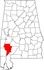 | |
| Towns | ||
| CDPs | ||
| Unincorporated communities | ||
| Ghost towns | ||