Coffeeville, Alabama
| Coffeeville, Alabama | |
|---|---|
| Town | |
|
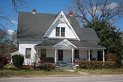
Victorian house on Alabama State Route 69 in Coffeeville | |
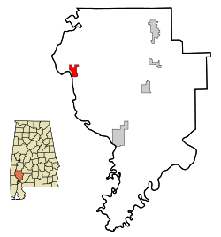 Location in Clarke County and the state of Alabama | |
| Coordinates: 31°45′40″N 88°5′20″W / 31.76111°N 88.08889°W | |
| Country | United States |
| State | Alabama |
| County | Clarke |
| Area | |
| • Total | 4.5 sq mi (11.7 km2) |
| • Land | 4.5 sq mi (11.7 km2) |
| • Water | 0 sq mi (0 km2) |
| Elevation | 174 ft (53 m) |
| Population (2010) | |
| • Total | 352 |
| • Density | 78/sq mi (30.1/km2) |
| Time zone | Central (CST) (UTC-6) |
| • Summer (DST) | CDT (UTC-5) |
| ZIP code | 36524 |
| Area code(s) | 251 |
| FIPS code | 01-16264 |
| GNIS feature ID | 0116356 |
Coffeeville is a town in Clarke County, Alabama, United States. At the 2010 census the population was 352.[1]
History
The town of Coffeeville was incorporated in 1817.[2]
In 1892, Coffeeville was the site for a violent confrontation around economic and racial divides that later became known as the Mitcham War.[3][4]
In 1939, racial violence in Coffeeville was brought to the attention of President Franklin D. Roosevelt after a near-lynching in which the mayor of Coffeeville was complicit.[5]
Geography
Coffeeville is located in northwestern Clarke County at 31°45'40.543" North, 88°5'20.940" West (31.761262, -88.089150),[6] on high ground on the east side of the Tombigbee River.
According to the U.S. Census Bureau, the town has a total area of 4.5 square miles (11.7 km2), all land.[1]
Demographics
| Historical population | |||
|---|---|---|---|
| Census | Pop. | %± | |
| 1870 | 280 | — | |
| 1880 | 104 | −62.9% | |
| 1940 | 250 | — | |
| 1950 | 211 | −15.6% | |
| 1960 | 250 | 18.5% | |
| 1970 | 441 | 76.4% | |
| 1980 | 448 | 1.6% | |
| 1990 | 431 | −3.8% | |
| 2000 | 360 | −16.5% | |
| 2010 | 352 | −2.2% | |
| Est. 2015 | 338 | [7] | −4.0% |
| U.S. Decennial Census[8] 2013 Estimate[9] | |||
As of the census[10] of 2000, there were 360 people, 165 households, and 97 families residing in the town. The population density was 79.7 people per square mile (30.8/km2). There were 209 housing units at an average density of 46.3 per square mile (17.9/km2). The racial makeup of the town was 61.11% White and 38.89% Black or African American.
There were 165 households out of which 22.4% had children under the age of 18 living with them, 40.6% were married couples living together, 13.9% had a female householder with no husband present, and 41.2% were non-families. 40.6% of all households were made up of individuals and 21.2% had someone living alone who was 65 years of age or older. The average household size was 2.18 and the average family size was 2.95.
In the town the population was spread out with 23.9% under the age of 18, 6.9% from 18 to 24, 23.1% from 25 to 44, 25.3% from 45 to 64, and 20.8% who were 65 years of age or older. The median age was 42 years. For every 100 females there were 80.9 males. For every 100 females age 18 and over, there were 80.3 males.
The median income for a household in the town was $19,545, and the median income for a family was $33,125. Males had a median income of $29,000 versus $17,500 for females. The per capita income for the town was $16,886. About 18.8% of families and 25.6% of the population were below the poverty line, including 42.2% of those under age 18 and 19.7% of those age 65 or over.
Notable people
- Tom Long, professional baseball outfielder[11]
- Ashton Shepherd, singer[12]
- Willie J. Slater, head football coach for the Tuskegee University Golden Tigers[13]
Coordinates: 31°45′41″N 88°05′21″W / 31.761262°N 88.08915°W
References
- 1 2 "Geographic Identifiers: 2010 Demographic Profile Data (G001): Coffeeville town, Alabama". U.S. Census Bureau, American Factfinder. Retrieved June 5, 2014.
- ↑ Burrage, Joyce White (1998). Clarke County. Charleston, South Carolina: Arcadia Publishing. p. 7. ISBN 9780738568713.
- ↑ "Mitcham War". Encyclopedia of Alabama. Retrieved 6 August 2012.
- ↑ "Start of Mitcham War". History Engine: Tools for Collaborative Education and Research. University of Richmond. Retrieved 6 August 2012.
- ↑ Lovell, George I. (2012). This Is Not Civil Rights: Discovering Rights Talk in 1939 America. Chicago, Illinois: University of Chicago Press. p. 88. ISBN 9780226494036.
- ↑ "US Gazetteer files: 2010, 2000, and 1990". United States Census Bureau. 2011-02-12. Retrieved 2011-04-23.
- ↑ "Annual Estimates of the Resident Population for Incorporated Places: April 1, 2010 to July 1, 2015". Retrieved July 2, 2016.
- ↑ "U.S. Decennial Census". Census.gov. Archived from the original on May 11, 2015. Retrieved June 6, 2013.
- ↑ "Annual Estimates of the Resident Population: April 1, 2010 to July 1, 2013". Retrieved June 3, 2014.
- ↑ "American FactFinder". United States Census Bureau. Archived from the original on 2013-09-11. Retrieved 2008-01-31.
- ↑ "Tom Long Statistics and History". Baseball-reference.com. Retrieved 12 February 2015.
- ↑ Leggett, Steve. "Ashton Shepherd biography". AllMusic. Retrieved 2008-04-08.
- ↑ "Willie Slater Head Football Coach". 2014 Football Coaching Staff. Tuskegee University. Retrieved 12 February 2015.
Municipalities and communities of Clarke County, Alabama, United States | ||
|---|---|---|
| Cities | 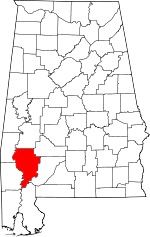 | |
| Towns | ||
| CDPs | ||
| Unincorporated communities | ||
| Ghost towns | ||