Grade II* listed buildings in Blaenau Gwent
Blaenau Gwent shown within Wales
In the United Kingdom, the term listed building refers to a building or other structure officially designated as being of special architectural, historical, or cultural significance; Grade II* structures are those considered to be "particularly important buildings of more than special interest".[1] Listing was begun by a provision in the Town and Country Planning Act 1947. Once listed, strict limitations are imposed on the modifications allowed to a building's structure or fittings. In Wales, the authority for listing under the Planning (Listed Buildings and Conservation Areas) Act 1990[2] rests with Cadw.
Buildings
| Name | Location | Date Listed | Grid Ref.[note 1] Geo-coordinates |
Function | Notes | HB No[note 2] | Image |
|---|---|---|---|---|---|---|---|
| The Town Clock | Tredegar | 25 May 1962 | SO1416308825 51°46′17″N 3°14′43″W / 51.77151694334°N 3.2454161271917°W |
Very prominently located in the centre of The Circle.
|
[Clock tower 1861] | 
| |
| SW Roundhouse at Roundhouse Farm | Nantyglo and Blaina | 29 June 1950 | SO1891910187 51°47′04″N 3°10′37″W / 51.784470584034°N 3.1768235887429°W |
Farm building | Roundhouse Farm is situated on the valley bottom, W of Nantyglo. Farm reached off the end of Waun Ebbw Road. SW tower located some 40 metres away from farmyard. | 1863 | 
|
| St Illtyd's Church | Llanhilleth | 6 June 1962 | SO2179801954 51°42′39″N 3°08′00″W / 51.710872215889°N 3.1332421888628°W |
Church | Set in centre of small settlement of St Illtyd, on N side of by-road. Large circular churchyard with remains of medieval churchyard cross some 10 metres N of church. | 1866 | 
|
| Former boiler house at Dunlop Semtex rubber factory | Brynmawr | 5 August 1986 | SO1906211463 51°47′45″N 3°10′30″W / 51.795961435026°N 3.1750491393883°W |
Boiler House | Prominently sited on the E side of the A467 on the S edge of Brynmawr, opposite main Dunlop Semtex factory complex (separately listed within Nantyglo and Blaina Community).[3]
|
1869 | 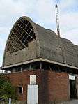
|
| NE Roundhouse at Roundhouse Farm | Nantyglo and Blaina | 29 June 1950 | SO1901310275 51°47′07″N 3°10′32″W / 51.785275266511°N 3.1754817643502°W |
Farm building | Roundhouse Farm is situated on the valley bottom, W of Nantyglo. Farm reached off the end of Waun Ebbw Road. NE tower located alongside main entrance to farmyard. | 17086 |
|
| Agricultural Range at Roundhouse Farm | Nantyglo and Blaina | 30 July 1996 | SO1895910227 51°47′05″N 3°10′35″W / 51.784835954895°N 3.1762532025761°W |
Farm building | Roundhouse Farm is situated on the valley bottom, W of Nantyglo. Farm reached off the end of Waun Ebbw Road, with the agricultural range situated S of the early C20 farmhouse. | 17087 |
|
| Milgatw | Tredegar | 14 October 1999 | SO1327411668 51°47′49″N 3°15′32″W / 51.796934933457°N 3.2590082087505°W |
House | Blaen-y-cwm is reached off the Tredegar-Trefil Road, from Nant-y-bwch. Located some 1 km N of Tredegar. Milgatw is located at the end of the no-through road. | 22494 |
|
| Sirhowy Ironworks | Tredegar | 14 October 1999 | SO1427810141 51°47′00″N 3°14′39″W / 51.783363995152°N 3.244075266218°W |
Ironworks | Graham’s Yard is located off Dukestown Road. Ironworks is set into hillside to E. | 22496 | 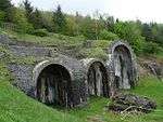
|
| British Steel Tinplate Works General Office | Ebbw Vale | 29 October 1999 | SO1714709429 51°46′39″N 3°12′08″W / 51.777396806712°N 3.2023247168914°W |
Works office | Prominently located along Steelworks Road, on E fringe of massive steelworks complex. | 22530 | 
|
| Furnace Bank | Ebbw Vale | 29 October 1999 | SO1715809728 51°46′48″N 3°12′08″W / 51.780086161335°N 3.2022367661738°W |
Furnaces | Set back from the E side of Steelworks Road, to rear of factory buildings, and opposite the main entrance to Ebbw Vale Steelworks. | 22531 | |
See also
- Listed buildings in Wales
- Grade II* listed buildings in Powys
- Grade II* listed buildings in Monmouthshire
- Grade II* listed buildings in Torfaen
- Grade II* listed buildings in Caerphilly
- List of Scheduled Monuments in Blaenau Gwent
Notes
- ↑ Sometimes known as OSGB36, the grid reference is based on the British national grid reference system used by the Ordnance Survey.
- ↑ The "HB Number" is a unique number assigned to each listed building by Cadw.
References
| Wikimedia Commons has media related to Grade II* listed buildings in Blaenau Gwent. |
- ↑ "Buildings & Conservation Areas". Cadw. Retrieved 18 June 2013.
- ↑ "Planning (Listed Buildings and Conservation Areas) Act 1990". The National Archives. Retrieved 18 June 2013.
- ↑ "Dunlop Semtex Rubber Factory: Boiler House". Royal Commission on the Ancient and Historical Monuments of Wales. NPRN 41230.
| Principal settlements | | |
|---|---|---|
| Communities |
| |
| Towns and villages |
| |
| Topics | ||
This article is issued from Wikipedia - version of the 5/2/2016. The text is available under the Creative Commons Attribution/Share Alike but additional terms may apply for the media files.