Grade II* listed buildings in Anglesey
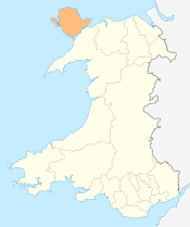
Anglesey shown within Wales
In the United Kingdom, the term listed building refers to a building or other structure officially designated as being of special architectural, historical, or cultural significance; Grade II* structures are those considered to be "particularly important buildings of more than special interest".[1] Listing was begun by a provision in the Town and Country Planning Act 1947. Once listed, strict limitations are imposed on the modifications allowed to a building's structure or fittings. In Wales, the authority for listing under the Planning (Listed Buildings and Conservation Areas) Act 1990[2] rests with Cadw.
Buildings
| Name | Location | Date Listed | Grid Ref.[note 1] Geo-coordinates |
Function | Notes | HB No[note 2] | Image |
|---|---|---|---|---|---|---|---|
| Presaddfed | Bodedern | 8 January 1952 | SH3506580951 53°17′59″N 4°28′35″W / 53.299758099993°N 4.4764552240615°W |
Country house | Located 1.5km ENE of Bodedern, near the S tip of Llyn Llywenan. Reached via a single track driveway. | 5262 | 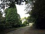
|
| Melin Llynon | Tref Alaw | 8 January 1952 | SH3405285229 53°20′16″N 4°29′38″W / 53.337857934943°N 4.493880591561°W |
Windmill | Set back from the N side of a country road leading W from the village of Llanddeusant, the mill is located c500m W of the Church of St Marcellus and St Marcellinus. | 5265 | 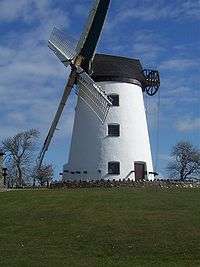
|
| Carreglwyd | Llanfaethlu | 8 January 1952 | SH3085887774 53°21′35″N 4°32′35″W / 53.359697160398°N 4.54316148627°W |
House | In an isolated location set within park and woodland. The house forms the centre to the Carreglwyd estate and is set back from the N and E sides of the Porth Swtan road, leading NE off the A5025. | 5267 | 
|
| St Beuno's Church | Aberffraw | 4 May 1971 | SH3533168802 53°11′27″N 4°27′58″W / 53.190738112943°N 4.4661825464478°W |
Church | Located within an enclosed churchyard, set back from the S side of Church Street, in the SW part of Aberffraw. | 5270 | 
|
| St Cwyfan's Church | Porth Cwyfan, Aberffraw | 4 May 1971 | SH3359368280 53°11′08″N 4°29′31″W / 53.185508022089°N 4.4918976947043°W |
Church | In an isolated location on an island c. 150m off the coast at Porth Cwyfan and reached by a rough causeway at low tide; the churchyard has been raised and is enclosed by a retaining rubble wall. | 5273 | 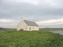
|
| St Edern's Church | Bodedern | 4 May 1971 | SH3335080450 53°17′41″N 4°30′07″W / 53.294720941672°N 4.501900381676°W |
Church | Situated on the N side of Church Street in the centre of the village of Bodedern. | 5276 | 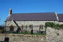
|
| St Twrog's Church, Bodwrog | Bodffordd | 4 May 1971 | SH4002277640 53°16′18″N 4°24′02″W / 53.271546716614°N 4.4004757306701°W |
Church | In an isolated rural location within an irregularly shaped churchyard along the NW side of a country road running SW from the B5109 at Llynfaes. | 5279 | 
|
| St Maethlu's Church | Llanfaethlu | 4 May 1971 | SH3126087084 53°21′13″N 4°32′12″W / 53.353629942092°N 4.5367589198092°W |
Church | Set back from the NE side of the Porth Swtan road, leading NE off the A5025 through the village of Llanfaethlu. | 5301 | 
|
| Old Church of St Afran, St Ieuan and St Sannan | Tref Alaw | 4 May 1971 | SH3495184062 53°19′40″N 4°28′47″W / 53.327660018444°N 4.4797838988752°W |
In an isolated rural location set within a sub-rectangular churchyard W of the farmstead at Ty-mawr. Set well back from the SW side of a country road, the church is located c1.5km NW of the new church in Llantrisant. | 5314 | 
| |
| Melin Hywel | Tref Alaw | 4 May 1971 | SH3507784476 53°19′53″N 4°28′41″W / 53.331417212268°N 4.4781094597504°W |
Mill | Set back from the N side of the country road between the villages of Llanddeusant and Llantrisant, the mill is located c950m SE of the Church of St Marcellus and St Marcellinus in the village of Llanddeusant. | 5317 | 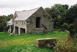
|
| St Peulan's Church | Bryngwran | 4 May 1971 | SH3725075480 53°15′05″N 4°26′27″W / 53.251303077692°N 4.440897810716°W |
Church | In an isolated rural location, within an irregularly shaped churchyard at the end of a raised trackway W of a country road between the A5(T) and Dothan. Located c. 1.75km SW of Gwalchmai and c. 3km SE of Bryngwran. | 5320 | 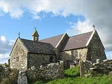
|
| St Morhaiarn's Church | Gwalchmai, Trewalchmai | 4 May 1971 | SH3904676110 53°15′27″N 4°24′52″W / 53.257510105852°N 4.4143229302°W |
Church | Located within an enclosed churchyard, at the end of a single track lane leading off the S side of the A5(T) Holyhead Road, at the W end of the village of Gwalchmai. | 5331 | 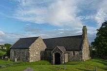
|
| Plas Bodewryd | Bodewryd, Mechell | 9 February 1952 | SH4001390822 53°23′24″N 4°24′26″W / 53.389927779921°N 4.4072703900919°W |
Hall | Set back from the NE side of the country road in the rural hamlet of Bodewryd, c3km ESE of Llanfechell. Plas Bodewryd lies c200m due N of the Church of St Mary. | 5334 | 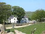
|
| Glyn | Llanfair Mathafarn Eithaf | 9 February 1952 | SH5154281332 53°18′29″N 4°13′47″W / 53.308066237086°N 4.2295987709026°W |
House | In an isolated rural location at the end of a private driveway off a country road, which leads W off the A5025 to the S of Benllech. | 5339 | 
|
| Tre'r Ddôl | Tref Alaw | 9 February 1952 | SH3916781176 53°18′11″N 4°24′54″W / 53.303043249473°N 4.415076005865°W |
House | In an isolated rural location, reached by private trackway leading N of a country road W of Llechcynfarwy; the house is located c1km ENE of the Church of St Cynfarway | 5345 | 
|
| St Pabo's Church, Llanbabo | Llanbabo, Tref Alaw | 5 December 1970 | SH3780586773 53°21′10″N 4°26′18″W / 53.352890758317°N 4.4383614825924°W |
Church | Set within a circular churchyard at the SE side of a country road between Llechcynfarwy and Carreglefn. | 5354 | 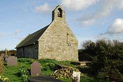
|
| St Padrig's Church | Cemaes Bay, Llanbadrig | 5 December 1970 | SH3761094640 53°25′25″N 4°26′43″W / 53.423479286569°N 4.4453364138514°W |
Church | In an isolated coastal location NW of the village of Cemaes Bay. The church is reached by a country road leading N off the A5025 E of Cemaes Bay. | 5356 | 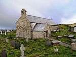
|
| St Dyfnan's Church | Llanddyfnan | 5 December 1970 | SH5026978706 53°17′03″N 4°14′51″W / 53.284120921229°N 4.2474493665435°W |
Church | In a rural location, set back from the N side of the B5109; NE of Talwrn and W of Pentraeth. | 5358 | 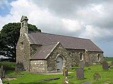
|
| St Tyfrydog's Church, Llandyfrydog | Llandyfrydog, Rhosybol | 5 December 1970 | SH4435485355 53°20′32″N 4°20′22″W / 53.342128909354°N 4.3393604004852°W |
Church | Located within a circular churchyard to W side of Lon Leidr in the centre of the small hamlet of Llandyfrydog. | 5360 | 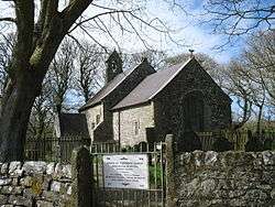
|
| St Gwenllwyfo's Church, Llanwenllwyfo | Llaneilian | 5 December 1970 | SH4771789330 53°22′44″N 4°17′27″W / 53.378811248622°N 4.2908059892225°W |
Church | Set back, within an irregularly shaped churchyard, from the W side of a country road between Nebo and Traeth Dulas; to the SW of the former Llys Dulas estate. | 5370 | 
|
| St Eugrad's Church | Parciau, Llaneugrad | 5 December 1970 | SH4955084166 53°19′59″N 4°15′39″W / 53.332956807356°N 4.2608160902349°W |
Church | In an isolated rural location within an oval churchyard set back from the SW side of a lane leading to the house and home farm at Parciau, W of Marian glas. | 5372 | 
|
| Parciau dovecote | Parciau, Llaneugrad | 5 December 1970 | SH4975983930 53°19′51″N 4°15′27″W / 53.330896661099°N 4.2575681685601°W |
Dovecote | In an isolated rural location, set back from the W side of the lane leading to the house and home farm at Parciau; to W of Marian glas | 5373 | 
|
| St Peter's Church | Llanbedrgoch, Llanfair Mathafarn Eithaf | 5 December 1970 | SH5093979855 53°17′41″N 4°14′17″W / 53.294630327905°N 4.2379472618081°W |
Church | In an isolated rural location, set back from the W side of a country road which leads N of the A5025 to the village of Llanbedrgoch. | 5374 | 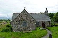
|
| St Mary's Church | Llanfair Mathafarn Eithaf | 5 December 1970 | SH5066682892 53°19′19″N 4°14′36″W / 53.321830944157°N 4.2434702342907°W |
Church | Slightly set back and at right angles to the E side of country road leading off the B5110 to the NE of the village of Brynteg. | 5375 | 
|
| Caerau | Llanfairynghornwy, Cylch-y-Garn | 5 December 1970 | SH3204291753 53°23′45″N 4°31′39″W / 53.395806374664°N 4.5275048388178°W |
House | In an isolated rural location set back from the W side of the country road between Llanfairynghornwy and Cemlyn; c750m NW of the Church of St Mary at Llanfairynghornwy. | 5381 |
|
| St Rhwydrys's Church | Cylch-y-Garn | 5 December 1970 | SH3221093224 53°24′33″N 4°31′33″W / 53.409069200433°N 4.5257635989864°W |
Church | In an isolated rural location near the coast at Cemlyn. The churchyard is reached via a trackway leading SW from the farmtrack to Tyn Llan farm, and then via a footpath across a field. | 5382 |
|
| St Mechell's Church | Mechell | 5 December 1970 | SH3694291273 53°23′35″N 4°27′13″W / 53.393036114831°N 4.4536375395779°W |
Church | Set within an irregularly shaped churchyard at the N side of the crossroads in the centre of the village of Llanfechell. | 5383 | 
|
| St Cwyllog's Church, Llangwyllog | Llangwllog, Llanddyfnan | 5 December 1970 | SH4338379668 53°17′27″N 4°21′04″W / 53.290766235825°N 4.3511216191565°W |
Church | In a rural location NNW of the small hamlet of Llangwllog, along a narrow lane leading SW off the B5111. | 5394 | 
|
| St Michael's Church, Penrhos Lligwy | Moelfre | 5 December 1970 | SH4805785920 53°20′54″N 4°17′03″W / 53.348282698482°N 4.2840595947525°W |
Church | In a rural location set back from the S side of a country road leading S from the village of Brynrefail towards Mynydd Bodafon; located S of the junction with another country road leading W. | 5398 | 
|
| St Caian's Church, Tregaian | Tregaian, Llanddyfnan | 5 December 1970 | SH4513079706 53°17′30″N 4°19′30″W / 53.291622204159°N 4.3249544661644°W |
Church | Within a rectangular churchyard at the W side of the B5111 in the centre of the small hamlet of Tregaian. | 5403 | 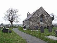
|
| St Tysilio's Church, Llandysilio | Menai Bridge | 14 February 1967 | SH5513871688 53°13′21″N 4°10′17″W / 53.222439368568°N 4.1712762446525°W |
Church | Located towards the south end of Church Island to the west of Menai Bridge. The island is reached by a causeway and the churchyard is enclosed by a low rubble wall with wrought iron gates at the entrance at the end of the causeway. | 5405 | 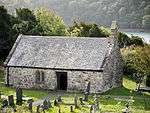
|
| The Cambria | Menai Bridge | 14 February 1967 | SH5568971648 53°13′20″N 4°09′47″W / 53.222230369105°N 4.1630114386158°W |
Near the foot of Menai Bridge on the E side, overlooking the Menai Straits, on the NW side of Cambria Road, leading from Beach Road. | 5406 |
| |
| St Eleth's Church | Amlwch | 25 October 1951 | SH4422492950 53°24′37″N 4°20′42″W / 53.410301568798°N 4.345057722062°W |
Church | Set back, within an irregularly shaped churchyard, from the E side of Queen Street in the centre of the town of Amlwch. | 5427 | 
|
| Aberbraint | Llanfair Pwllgwyngyll | 2 May 1952 | SH5268571264 53°13′05″N 4°12′28″W / 53.217954884349°N 4.207792878482°W |
House | Set back from the road within grounds on the NW side of the A4080 Brynsiencyn Road, c.0.5km from the Llanfairpwll Toll House. | 5430 |
|
| Marquess of Anglesey's Column | Llanfair Pwllgwyngyll | 2 May 1952 | SH5343271563 53°13′15″N 4°11′48″W / 53.220847613441°N 4.1967516071594°W |
Monument | Prominently sited on a hill called Cerrig y Borth overlooking the Menai Strait, N of the A4080(T) Holyhead road, on the approach to Llanfairpwll. | 5432 | 
|
| Dinam | Rhosyr | 2 May 1952 | SH4532968950 53°11′42″N 4°19′00″W / 53.195076558247°N 4.316745134875°W |
House | Located at the end of a private driveway off the SE side of the B4419, NE of Llangaffo and c800m NE of the Church of St Caffo. | 5434 |
|
| Tros-y-marian | Llangoed | 2 May 1952 | SH6110881147 53°18′32″N 4°05′10″W / 53.309005446144°N 4.0860542638833°W |
House | Set back, within private grounds, from the N side of a country road running between Penmon and Glan-yr-afon, N of the village of Llangoed; c0.6km N of the Church of St Cawdraf. | 5436 | 
|
| Eirianallt | Llangoed | 2 May 1952 | SH6062880928 53°18′25″N 4°05′35″W / 53.306911866417°N 4.0931569078461°W |
House | Set back, and below, the S side of a country road running between Penmon and Glan-yr-afon, to the N of the village of Llangoed; c0.6km NW of the Church of St Cawdraf. | 5438 |
|
| Henblas | Llangristiolus | 2 May 1952 | SH4227272538 53°13′35″N 4°21′51″W / 53.226400865249°N 4.3642378134142°W |
House | In private grounds, set back, along a driveway, from the SE side of the B4422. The house lies c2.5km SW of the church of St. Cristiolus. | 5439 |
|
| Plas Penmynydd | Penmynydd | 2 May 1952 | SH4959175199 53°15′09″N 4°15′21″W / 53.252429513687°N 4.2559511850962°W |
House | In an isolated rural location, set back from the N side of the B5420 NW of Penmynydd. | 5447 |
|
| No 1 Lewis Rogers Almshouses | Penmynydd | 2 May 1952 | SH5136174239 53°14′40″N 4°13′44″W / 53.244306717328°N 4.2289942674556°W |
Almshouses | Set at right angles to the S side of the B5420 in the centre of the village of Penmynydd; No 1 is located nearest the road, at the N (R) end of the range. | 5448 | 
|
| Plas Gwyn | Pentraeth | 2 May 1952 | SH5285478182 53°16′49″N 4°12′30″W / 53.280139909941°N 4.2084630762348°W |
House | Set back, within private grounds, between the A5025 and the B5109 SW of Pentraeth. | 5450 |
|
| Tŷ Fry | Pentraeth | 2 May 1952 | SH5162876755 53°16′01″N 4°13′34″W / 53.266980208152°N 4.2261699424614°W |
House | Set back, within private grounds, from the NW side of a country road leading W off the A5025 through the small hamlet of Rhoscefnhir. | 5451 |
|
| Priory House | Llangoed | 14 November 1968 | SH6303380717 53°18′20″N 4°03′25″W / 53.305645239785°N 4.0569973163016°W |
Priory | Slightly set back from the N side of a country road leading to the SE tip of the island at Black Point, or Trwyn Du, Penmon. The Priory House forms the W side of a cloister yard; linking the Church to the N and the refectory to the S. | 5454 | 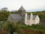
|
| Plas Berw with courtyard and walls | Llanfihangel Ysgeifiog | 30 January 1968 | SH4657271768 53°13′15″N 4°17′58″W / 53.220747600494°N 4.2995104611881°W |
House | In an isolated location, at the end of a single track lane, NW of the B4419, and c1.3km WSW of the Church of St Michael (new church) in Gaerwen. | 5500 |
|
| Bodorgan | Bodorgan | 30 January 1968 | SH3859367371 53°10′44″N 4°25′00″W / 53.178889050647°N 4.4166827911118°W |
House | Located in the heart of private estate grounds at the W side of, and overlooking, the Malltraeth estuary. Formal terraced garden to E. The house lies c. 3.5km SE of Aberffraw and c. 1.5km S of the A4080 at Hermon. | 5502 |
|
| St Mary's Church, Llanfair-yn-y-Cwmwd | Llanfair-yn-y-Cwmwd, Rhosyr | 30 January 1968 | SH4470266764 53°10′31″N 4°19′30″W / 53.175259940936°N 4.3250595013451°W |
Church | Set within an enclosed churchyard, set back from the NW side of a country lane running NE from the A4080; c1.2km NE of the Church of St Ceinwen and c1km N of Dwyran. | 5513 | 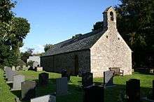
|
| Castell Aberlleiniog | Llangoed | 30 January 1968 | SH6164079307 53°17′33″N 4°04′38″W / 53.292616702437°N 4.0772727647692°W |
House | In an isolated location, along a trackway, to the N and W of a country road leading to Penmon; to the W of the village of Llangoed. The structure is to the N side of the Afon Lleiniog c0.5km from the coast. | 5523 | 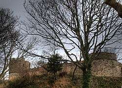
|
| St Cristiolus's Church | Llangristiolus | 30 January 1968 | SH4500273568 53°14′11″N 4°19′26″W / 53.236457303243°N 4.3238805956365°W |
Church | In an elevated position overlooking, and set back from, the SE side of the A5(T). | 5530 | 
|
| Old Church of St Nidan | Llanidan | 30 January 1968 | SH4949566903 53°10′40″N 4°15′13″W / 53.177888869702°N 4.2534728533096°W |
Church | Set within a stone walled circular churchyard, 20m N of Llanidan House, and c750m SE of the new Church of St. Nidan. | 5538 | 
|
| Llanidan Hall | Llanidan | 30 January 1968 | SH4949366874 53°10′39″N 4°15′13″W / 53.177627827271°N 4.2534890951444°W |
Hall | Located 20m S of the Church of St. Nidan (old church), c1.2 km E of Brynsiencyn, set within a boundary wall. | 5540 |
|
| St Michael's Church | Llanddona | 30 January 1968 | SH5880281508 53°18′42″N 4°07′15″W / 53.311637019676°N 4.1207993358445°W |
Church | In an isolated rural location under the E slopes of Bwrdd Arthur, to NE of Llanddona. | 5544 | 
|
| St Iestyn's Church, Llaniestyn | Llaniestyn, Llanddona | 30 January 1968 | SH5849979594 53°17′40″N 4°07′28″W / 53.294363467859°N 4.1244898764731°W |
Church | In an isolated rural location, set back from a country lane leading E out of the village of Llanddona. | 5545 | 
|
| St Sadwrn's Church, Llansadwrn | Llansadwrn, Anglesey, Cwm Cadnant | 30 January 1968 | SH5538975877 53°15′36″N 4°10′10″W / 53.260134891623°N 4.1694225910052°W |
Church | Set back from the E side of the road through the village of Llansadwrn. | 5548 | 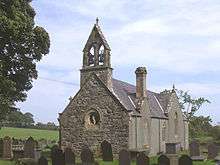
|
| St Peter's Church | Newborough, Anglesey, Rhosyr | 30 January 1968 | SH4199165470 53°09′46″N 4°21′54″W / 53.162838263678°N 4.364945021665°W |
Church | Set back from the road, within an enclosed churchyard, at the west side of the village. | 5553 | .jpg)
|
| St Gredifael's Church | Penmynydd | 30 January 1968 | SH5172074971 53°15′04″N 4°13′26″W / 53.25098216608°N 4.2239597658674°W |
Church | Set back from the E side of the junction between two country roads to the N of the village of Penmynydd. | 5555 | 
|
| St Beuno's Church, Trefdraeth | Trefdraeth, Bodorgan | 30 January 1968 | SH4086170394 53°12′24″N 4°23′03″W / 53.206723670555°N 4.3842845818021°W |
Church | Located in the centre of the small hamlet of Trefdraeth; set back from the N side of the road leading E from Bethel. | 5564 | 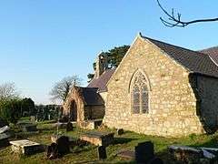
|
| Red Hill | Beaumaris | 23 September 1950 | SH5921475920 53°15′42″N 4°06′44″W / 53.261552258689°N 4.1121418148696°W |
House | Reached by private drive on the S side of the B5109 approximately 1.5km W of Beaumaris town centre. | 5575 |
|
| Beaumaris Courthouse | Beaumaris | 23 September 1950 | SH6069676154 53°15′51″N 4°05′24″W / 53.264046300323°N 4.0900423444234°W |
Courthouse | On the E side of Mona Place directly opposite Beaumaris Castle. | 5581 | 
|
| Ye Olde Bull's Head Inn including attached rear range | Beaumaris | 23 September 1950 | SH6058876107 53°15′49″N 4°05′30″W / 53.263595676952°N 4.0916397890599°W |
Inn | On the corner of Castle Street and Rating Row. | 5601 | 
|
| Tudor Rose | Beaumaris | 23 September 1950 | SH6054976073 53°15′48″N 4°05′32″W / 53.263279990449°N 4.0922091661403°W |
House | Fronting the street in a block of buildings between Church Street and Rating Row. | 5605 | .jpg)
|
| Bishopsgate Hotel & Restaurant | Beaumaris | 23 September 1950 | SH6045275990 53°15′45″N 4°05′37″W / 53.262508859812°N 4.0936259592712°W |
Hotel | On the corner of Castle Street and Steeple Lane. | 5611 | 
|
| Liverpool Arms Hotel | Beaumaris | 23 September 1950 | SH6044175982 53°15′45″N 4°05′38″W / 53.262434097923°N 4.0937872433175°W |
Hotel | Fronting the street in the block of buildings near the W end of Castle Street between Gadlys Lane and Steeple Lane. | 5612 |
|
| George and Dragon Hotel | Beaumaris | 23 September 1950 | SH6052476070 53°15′48″N 4°05′33″W / 53.263246455406°N 4.0925823931387°W |
Hotel | Fronting the street and set back from the junction with Castle Street. | 5617 | 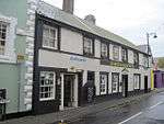
|
| Royal Anglesey Yacht Club
6–7 Green Edge |
Beaumaris | 23 September 1950 | SH6074676137 53°15′50″N 4°05′21″W / 53.263906749925°N 4.0892857959609°W |
Yacht Club | At the E end of the terrace, with its front facing NE in view of the castle. | 5635 | 
|
| Baron Hill | Beaumaris | 23 September 1950 | SH5982776527 53°16′02″N 4°06′12″W / 53.267167423864°N 4.103226122301°W |
House | In extensive grounds although now obscured by woodland, in a prominent position overlooking Beaumaris Castle, approximately 0.9km NW of Beaumaris town centre, on the N side of the B5109. | 5694 |
|
| Holyhead Breakwater, Soldier's Point | Holyhead | 19 July 1988 | SH2451984185 53°19′31″N 4°38′11″W / 53.325399266339°N 4.6363188493789°W |
Breakwater | 5743 | 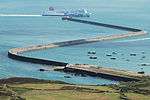
| |
| Capel Ebeneser and chapel house (formerly Capel Cildwrn) | Llangefni | 18 October 1988 | SH4517075998 53°15′30″N 4°19′21″W / 53.258331175262°N 4.3225478849688°W |
Chapel | Located at the brow of a hill at the W end of Llangefni, set at right angles to the N side of Ffordd Cildwrn with graveyard to front; c.600m W of the church of St. Cyngar. | 5749 | 
|
| Moriah Calvinistic Methodist Chapel including forecourt wall and gates | Llangefni | 16 June 1989 | SH4592575557 53°15′17″N 4°18′40″W / 53.254590683898°N 4.3110260310605°W |
Chapel | Set back, behind a railed forecourt, from the E side of the A5114 Glanhwfa Road. The chapel is located directly N of the Shire Hall and is c.400m SSE of the church of St. Cyngar. | 5751 | 
|
| Tros-y-gors | Llangoed | 2 March 1992 | SH6110079480 53°17′39″N 4°05′08″W / 53.294029142987°N 4.0854442095802°W |
House | Situated to E of B 5109 through Llangoed; reached from N end of the village along lane and then short private track. Faces N; rubble forecourt wall. | 5761 |
|
| Kingsland Windmill, Mill Road (South side) | Holyhead | 8 January 1952 | SH2485281063 53°17′51″N 4°37′47″W / 53.297476900495°N 4.6296000253564°W |
Windmill | Prominent building set within a modern housing estate reached W off B4545 approximately 1km south of Holyhead town centre. | 5762 | 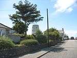
|
| Harbour Office, Salt Island | Holyhead | 3 November 1993 | SH2522982947 53°18′52″N 4°37′30″W / 53.314518612759°N 4.6249877202089°W |
Office | 5772 |
| |
| George IV Arch, Salt Island | Holyhead | 3 November 1993 | SH2524482909 53°18′51″N 4°37′29″W / 53.314182367744°N 4.6247418632897°W |
Arch | 5773 | 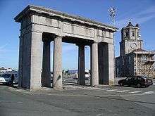
| |
| Skerries Lighthouse with associated buildings and enclosure walls | Cylch-y-Garn | 29 March 1996 | SH2677394768 53°25′16″N 4°36′30″W / 53.4211714071°N 4.6083170831373°W |
Lighthouse | Towards the S end of The Skerries Islands, at their highest point. 11.5km N of Holyhead. | 18028 | _off_NW_Anglesey._-_geograph.org.uk_-_96494.jpg)
|
| Detached former Keeper's Dwelling at Skerries Lighthouse | Cylch-y-Garn | 29 March 1996 | SH2675594788 53°25′17″N 4°36′31″W / 53.421345061763°N 4.6085986523971°W |
House | On low ground N of the lighthouse. | 18029 |
|
| Capel Mawr Presbyterian Chapel | Menai Bridge | 18 July 1997 | SH5569471803 53°13′25″N 4°09′47″W / 53.223624001097°N 4.1630067937141°W |
Chapel | Prominently sited on the corner of Chapel Street and New Street. | 18556 | 
|
| Plas Coch | Llandaniel Fab | 23 April 1998 | SH5117068440 53°11′32″N 4°13′45″W / 53.192166509844°N 4.229146818681°W |
House | Standing in parkland 600m NW of the parish church of St. Edwen. | 19736 |
|
| St Ceinwen's Church, Llangeinwen | Llangeinwen, Rhosyr | 30 January 1968 | SH4397065820 53°10′00″N 4°20′08″W / 53.16656685865°N 4.335541158881°W |
Church | Located within an enclosed churchyard on the NW side of a right-angle corner of the A4080, c800m W of the village of Dwyran and c1.5km E of Newborough. | 20553 | 
|
| Prichard Jones Institute | Newborough, Anglesey, Rhosyr | 19 October 1998 | SH4251865804 53°09′58″N 4°21′26″W / 53.165994540393°N 4.3572339797969°W |
Institute | Set back from the NW side of Pen-dref Street, within grounds also housing 6 cottage homes built to front of the Institute, c650m NE of the Church of St Peter in Newborough. | 20554 | 
|
| Mona and Mona Isaf | Llangristiolus | 23 December 1998 | SH4254774933 53°14′53″N 4°21′41″W / 53.247992484732°N 4.3613063561484°W |
House | The house is prominently sited, and set back slightly, from the SW side of the A5(T), with courtyard range to the rear; c2.5km NE of the church of St Cristiolus. | 21069 |
|
| Trwyn Du, or Black Point, Lighthouse | Llangoed | 26 March 1999 | SH6414381498 53°18′47″N 4°02′26″W / 53.312947421936°N 4.0406853251698°W |
Lighthouse | Situated in the strait between Black Point, or Trwyn Du, Penmon, Anglesey and Puffin Island, close to the shore but accessible only at low tide. | 21615 | 
|
| Corn Mill at Felin Gafnan | Porth y Felin, Cylch-y-Garn | 27 November 2000 | SH3447693354 53°24′39″N 4°29′30″W / 53.410954197429°N 4.4917769613962°W |
Corn mill | In an isolated rural location near the coast at Porth y Felin. Set back from the N side of the country road running along the N coast of the island at Cemlyn Bay. The mill is located c2.25km E of the Church of St Rhwydrys. | 24416 |
|
| Church of Our Lady Star of the Sea and St Winefride | Amlwch | 12 December 2000 | SH4380493101 53°24′42″N 4°21′05″W / 53.411533224508°N 4.3514454633492°W |
In an elevated position, set back from the N side of the A5025 on the way out to Porth Llechog (Bull Bay). | 24455 | 
| |
| Gronant | Llanfachraeth | 19 December 2000 | SH3270885173 53°20′13″N 4°30′50″W / 53.336930642165°N 4.5140156397827°W |
House | Located at the end of a long trackway leading off the NE side of the A5025, N of Llanfachraeth. Gronant is reached via a driveway to the R of the access track, immediately before the farm entrance. | 24468 |
|
| Range including cornbarn, granary, threshing room and lofted cowhouse at Llwydiarth Esgob Farm | Rhosybol | 21 February 2001 | SH4352084394 53°20′00″N 4°21′05″W / 53.33325145921°N 4.3514009421281°W |
Farm buildings | Set well back, along a private driveway, from the N side of a country road leading E off the B5111 out of Llanerchymedd towards Benllech. The corn barn range is to the W of the farmhouse. | 24836 | 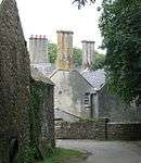
|
| Range including cowhouse, stables, coach house, smithy and poultry house at Llwydiarth Esgob Farm | Rhosybol | 21 February 2001 | SH4352384424 53°20′01″N 4°21′05″W / 53.333521780227°N 4.3513707581014°W |
Farm buildings | Set well back, along a private driveway, from the N side of a country road leading E off the B5111 out of Llanerchymedd towards Benllech. The cowhouse, stables and coach house range is located to the rear (NW) of the farmhouse. | 24837 |
|
| Range including pigsties, laundry, slaughter house, cartsheds and coalshed at Llwydiarth Esgob Farm | Rhosybol | 21 February 2001 | SH4356384441 53°20′01″N 4°21′03″W / 53.333686314941°N 4.3507790096961°W |
Farm buildings | Set well back, along a private driveway, from the N side of a country road leading E off the B5111 out of Llanerchymedd towards Benllech. The pigsty, laundry and slaughter house range is located NE of the farmhouse. | 24838 |
|
| Hammels at Llwydiarth Esgob Farm | Rhosybol | 21 February 2001 | SH4363784391 53°20′00″N 4°20′59″W / 53.333259188701°N 4.3496440369385°W |
Set well back, along a private driveway, from the N side of a country road leading E off the B5111 out of Llanerchymedd towards Benllech. The hammels are located to E of the farmhouse. | 24839 |
| |
| Ysgol Syr Thomas Jones | Amlwch | 31 October 2001 | SH4374692096 53°24′09″N 4°21′07″W / 53.402490165504°N 4.3518190896553°W |
School | Set back, within private grounds, from the SW side of Ffordd Tanybryn in Pentrefelin. | 25852 |
|
| No 2 Lewis Rogers Almshouses | Penmynydd | 2 May 1952 | SH5135874231 53°14′39″N 4°13′45″W / 53.244234019665°N 4.2290354526034°W |
Almshouses | Set at right angles to the S side of the B5420 in the centre of the village of Penmynydd. | 26140 |
|
| No 3 Lewis Rogers Almshouses | Penmynydd | 2 May 1952 | SH5135574223 53°14′39″N 4°13′45″W / 53.244161321988°N 4.2290766376148°W |
Almshouses | Set at right angles to the S side of the B5420 in the centre of the village of Penmynydd. | 26141 |
|
| No 4 Lewis Rogers Almshouses | Penmynydd | 2 May 1952 | SH5135274215 53°14′39″N 4°13′45″W / 53.244088624297°N 4.2291178224897°W |
Almshouses | Set at right angles to the S side of the B5420 in the centre of the village of Penmynydd. | 26142 |
|
| No 5 Lewis Rogers Almshouse | Penmynydd | 2 May 1952 | SH5134974206 53°14′38″N 4°13′45″W / 53.244006944633°N 4.229158540192°W |
Almshouses | Set at right angles to the S side of the B5420 in the centre of the village of Penmynydd. | 26143 |
|
| Dovecote and barn at Penmon Priory | Llangoed | 17 July 2002 | SH6311480718 53°18′20″N 4°03′21″W / 53.305675207143°N 4.0557829990529°W |
Dovecote | Set at the S side of a country road leading to the SE tip of the island at Black Point, or Trwyn Du, Penmon. | 26763 |
|
| Plas Rhianfa | Cwm Cadnant | 9 June 2004 | SH5701473385 53°14′17″N 4°08′38″W / 53.23819°N 4.14396°W |
Stately home | Built in 1851 on the family estate, set back from the A545 Beaumaris Road out of Menai Bridge towards Beaumaris. The Gatehouse, Summerhouse and Dovecote are also listed buildings. | 81142 | 
|
| 1 Green Edge | Beaumaris | 23 September 1950 | SH6072376113 53°15′49″N 4°05′23″W / 53.26369°N 4.08962°W |
House | Part of a terrace of houses built in 1825. Set back from the street and at the west end of the terrace, on the corner with Mona Place. | 84677 |
|
| 2 Green Edge | Beaumaris | 23 September 1950 | SH6072876117 53°15′49″N 4°05′22″W / 53.26372°N 4.08955°W |
House | Part of a terrace of houses built in 1825, set back from the street. | 84702 |
|
| 3 Green Edge | Beaumaris | 23 September 1950 | SH6073476121 53°15′50″N 4°05′22″W / 53.26376°N 4.08946°W |
House | Part of a terrace of houses built in 1825, set back from the street. | 84718 |
|
| 4 Green Edge | Beaumaris | 23 September 1950 | SH6073876125 53°15′50″N 4°05′22″W / 53.26380°N 4.08940°W |
House | Part of a terrace of houses built in 1825, set back from the street. | 84728 |
|
| 5 Green Edge | Beaumaris | 23 September 1950 | SH6074376128 53°15′50″N 4°05′22″W / 53.26383°N 4.08933°W |
House | Part of a terrace of houses built in 1825, set back from the street. | 84734 | |
Notes
- ↑ Sometimes known as OSGB36, the grid reference is based on the British national grid reference system used by the Ordnance Survey.
- ↑ The "HB Number" is a unique number assigned to each listed building by Cadw.
See also
References
- ↑ "Buildings & Conservation Areas". Cadw. Retrieved 18 June 2013.
- ↑ "Planning (Listed Buildings and Conservation Areas) Act 1990". The National Archives. Retrieved 18 June 2013.
External links
![]() Media related to Grade II* listed buildings in Anglesey at Wikimedia Commons
Media related to Grade II* listed buildings in Anglesey at Wikimedia Commons
This article is issued from Wikipedia - version of the 9/16/2016. The text is available under the Creative Commons Attribution/Share Alike but additional terms may apply for the media files.