Grade II* listed buildings in Gwynedd

Gwynedd shown within Wales
In the United Kingdom, the term listed building refers to a building or other structure officially designated as being of special architectural, historical, or cultural significance; Grade II* structures are those considered to be "particularly important buildings of more than special interest".[1] Listing was begun by a provision in the Town and Country Planning Act 1947. Once listed, strict limitations are imposed on the modifications allowed to a building's structure or fittings. In Wales, the authority for listing under the Planning (Listed Buildings and Conservation Areas) Act 1990[2] rests with Cadw.
Buildings
| Name | Location | Date Listed | Grid Ref.[note 1] Geo-coordinates |
Function | Notes | HB No[note 2] | Image |
|---|---|---|---|---|---|---|---|
| Pen-y-bryn | Aber | 22 February 1952 | SH6582472739 53°14′05″N 4°00′42″W / 53.234693339478°N 4.011771184406°W |
Manor house | Situated on rising ground above the A55 on the north-east side of the Afon Aber to the east of the village. | 3651 | 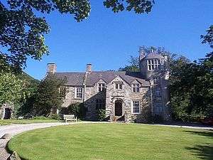
|
| Gatehouse/Barn at Pen-y-bryn | Aber | 3 March 1966 | SH6584172795 53°14′07″N 4°00′42″W / 53.235200705237°N 4.0115402460733°W |
Gateway | Located to north-east of Pen-y-bryn, from which it is separated by a stone wall/hedge; grassed over cobbled surfaces immediately adjoining on east side. | 3656 | 
|
| Church of St Tegai | Llandygai | 3 March 1966 | SH6007670987 53°13′03″N 4°05′49″W / 53.217468924487°N 4.0970599447722°W |
Church | Located at north-eastern end of village. | 3657 | .jpg)
|
| Grand Lodge and forecourt walling | Llandygai | 3 March 1966 | SH5978870979 53°13′02″N 4°06′05″W / 53.217320979197°N 4.1013665370287°W |
Gatehouse | Situated at the main entrance to Penrhyn Castle with forecourt and green to south; incorporated in park wall which runs to east and briefly to west before turning north-west towards Bangor; 2 large Douglas fir trees sit in the lawned forecourt. | 3661 | .jpg)
|
| Lon-Isaf Gate | Llandygai | 3 March 1966 | SH6018869380 53°12′11″N 4°05′41″W / 53.203063095912°N 4.0946792553087°W |
Gate | Located on its own on west side of former London to Holyhead Road, which is now by-passed by the present A5 and serves as a minor gated road between the A5 and Llandygai; cottage has low rubblestone boundary wall with stone-on-edge coping. | 3665 |
|
| Hafod Lwyfog | Beddgelert | 29 April 1952 | SH6525952235 53°03′01″N 4°00′42″W / 53.050355183116°N 4.0116019459458°W |
Located on the SE side of the Gwynant valley near the upper (NE) end of Llyn Gwynant, and accessed from the road via a short track; set behind low rubble forecourt walls with slate-flagging in front and a steep slope to the rear. | 3675 |
| |
| Plas Newydd | Llandwrog | 29 April 1952 | SH4499554439 53°03′53″N 4°18′53″W / 53.06464741547°N 4.3147217081974°W |
Situated in sheltered parkland position near the Afon Llifon, the house is moated on 3 sides with a stone bridge on the north-west side; surrounding garden with stone walls, that on south-east side a retaining wall with a well to south-west corner. | 3683 |
| |
| Plas Glan-yr-Afon | Waunfawr | 29 April 1952 | SH5040759830 53°06′53″N 4°14′12″W / 53.114616581151°N 4.2365330408713°W |
Located on the north side of a long, rough track running south-eastwards towards Waenfawr from the road between Bontnewydd and Caeathro; the house is separated from its farmbuildings by a rubblestone wall with stone-on-edge coping. | 3688 |
| |
| St Mary's Church | Beddgelert | 14 December 1961 | SH5909248036 53°00′40″N 4°06′06″W / 53.011042077388°N 4.1017030954346°W |
Church | Located in the village centre at the end of the lane and set within its own walled churchyard. | 3689 | 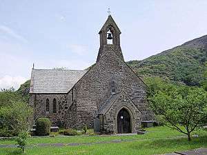
|
| Berth-Lwyd | Beddgelert | 29 May 1968 | SH6280948050 53°00′44″N 4°02′47″W / 53.01213540111°N 4.0463459047248°W |
Located on the northern slopes of the Nantmor valley, some 3km NE of Nantmor; accessed via an unmetalled track leading W off the unclassified road running SW from Nantgwynant. | 3741 |
| |
| Capel Anwes | Beddgelert | 29 May 1968 | SH6104646201 52°59′42″N 4°04′19″W / 52.995069670325°N 4.0718097155862°W |
Located high up on the W slopes of the Nanmor valley, above the Dolfriog woods, approximately 2km E of Nantmor village; located in a field and accessed via a lane leading NE off the unclassified road from Nanmor to Bethania. | 3752 |
| |
| Ffynnon Beuno | Clynnog | 29 May 1968 | SH4132249453 53°01′08″N 4°22′01″W / 53.018785389407°N 4.3670305062492°W |
Well | The well stands at the SW end of the village, close to the main road, and reached by a short path from the main road to Llanaelhaearn. | 3759 | 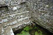
|
| Church of St Peris | Llanberis | 29 May 1968 | SH6065658291 53°06′13″N 4°04′58″W / 53.103574283655°N 4.0828487032633°W |
Church | Located in the centre of Nant Peris at the western end of the Pass of Llanberis in a roughly rectangular-shaped churchyard with a stone lychgate dated 1929 on the northern side. | 3769 | 
|
| Tower at Fort Williamsburg | Llandwrog | 29 May 1968 | SH4599855099 53°04′15″N 4°18′00″W / 53.070866133806°N 4.3000823484884°W |
Tower | Situated approximately 0.5km south-east of the house and reached by the south drive. The tower is the focal building within the Fort and is built on a mound near its north-west corner, between inner and outer bastions and reached via a tunnel. | 3791 | .jpg)
|
| Church of St Rhedyw | Llanllyfni | 29 May 1968 | SH4707052103 53°02′39″N 4°16′58″W / 53.044265058624°N 4.282672092215°W |
Church | Prominently sited on a corner on Ffordd Rhedyw within a raised rubble-walled churchyard on sloping ground down towards the Afon Lyfni. | 3799 | .jpg)
|
| Church of St Michael | Llanrug | 29 May 1968 | SH5269263081 53°08′40″N 4°12′14″W / 53.144455501971°N 4.2039150087929°W |
Church | Situated on its own in originally rectangular churchyard, now extended to north-east and south-east, on track between Bryn-llan and Plas Tirion approximately 0.75km south-west of Llanrug. | 3802 | 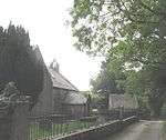
|
| Bryn Bras Castle | Llanrug | 29 May 1968 | SH5434762579 53°08′25″N 4°10′44″W / 53.140402402905°N 4.1789618539912°W |
Country house | The house occupies a triangular site at the junction of the road between Cwm-y-glo and Llanrug and the mountain route from Llanrug to Llanberis; the drive and parking area on the north represent the line of the old Cwm-y-glo to Llanrug road. | 3804 | 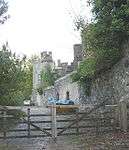
|
| Wern | Waunfawr | 29 May 1968 | SH5036161169 53°07′36″N 4°14′16″W / 53.126630673623°N 4.237844657152°W |
Situated at the end of a drive-way off the south-east side of the road by-passing Caeathro between Pont-rug and Bontnewydd; low rubblestone wall to front of main range with square piers and iron gate aligned on entrance. | 3812 |
| |
| Capel Pendref | Caernarfon | 31 March 1983 | SH4801962948 53°08′31″N 4°16′25″W / 53.141945315125°N 4.2736603285247°W |
Chapel | An isolated building on the N side of the junction with Pavilion Road. | 3822 | 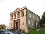
|
| Tanybont Arch, including former lock-up to SE | Caernarfon | 8 October 1953 | SH4790962823 53°08′27″N 4°16′31″W / 53.140791123601°N 4.2752441068486°W |
To the E of the East Gate of the Town Wall. | 3823 |
| |
| Palace Vaults | Caernarfon | 8 October 1953 | SH4784462723 53°08′24″N 4°16′34″W / 53.139874339412°N 4.276167519167°W |
Inn | Directly opposite Caernarfon Castle and on the corner of the junction of Castle Ditch with Palace Street. | 3832 | 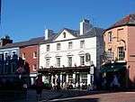
|
| East Gate, incorporating 3 Hole-in-the-Wall Street | Caernarfon | 31 March 1983 | SH4790162823 53°08′27″N 4°16′31″W / 53.140788834607°N 4.2753636049245°W |
Town gate | The E end of High Street. | 3869 | 
|
| Ty Sidan | Caernarfon | 29 May 1968 | SH4778762809 53°08′26″N 4°16′37″W / 53.140630457869°N 4.2770597968323°W |
In a row of frontages near the W end of the street. | 3873 |
| |
| Castle House | Caernarfon | 8 October 1953 | SH4779362811 53°08′26″N 4°16′37″W / 53.140650139548°N 4.2769711242296°W |
At the junction of High Street and Castle Street. | 3874 |
| |
| 38–40 High Street | Caernarfon | 10 August 1953 | SH4788362809 53°08′26″N 4°16′32″W / 53.140657938323°N 4.2756258258104°W |
Shop | In a row of frontages near the E end of the street. | 3878 |
|
| Days Gone By Antiques | Caernarfon | 31 March 1983 | SH4785062780 53°08′25″N 4°16′34″W / 53.140388020906°N 4.2761049763638°W |
In a row of frontages midway along the street. | 3909 |
| |
| Llys Llewelyn | Caernarfon | 8 October 1953 | SH4784762747 53°08′24″N 4°16′34″W / 53.140090761945°N 4.27613411009°W |
House | In a row of frontages near the S end of the street. | 3912 | 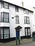
|
| Caernarfon Harbour Trust Offices | Caernarfon | 8 October 1953 | SH4790762608 53°08′20″N 4°16′31″W / 53.138859457248°N 4.275171882128°W |
Offices | On Slate Quay to the SE of and facing the castle. | 3932 | 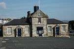
|
| Bangor Pier, Garth Road | Bangor | 31 October 1974 | SH5841573254 53°14′15″N 4°07′23″W / 53.237391582717°N 4.122925130842°W |
Pier | 3987 | .jpg)
| |
| Terraced Walls at, and Gated Entrance to, the University College of North Wales Main Building, Penrall | Bangor | 8 February 1988 | SH5790972272 53°13′42″N 4°07′48″W / 53.228435234365°N 4.1300630122679°W |
Walls/Gate | 4092 |
| |
| Plas Penisarnant | Llanllechid | 24 September 1985 | SH6307965070 53°09′54″N 4°02′58″W / 53.165099984654°N 4.049579206691°W |
At the foot of Nant Ffrancon, between the A5 and the river Ogwen, in wooded grounds. | 4139 |
| |
| Former Hospital and boundary walls | Llanddeiniolen | 2 July 1989 | SH5832760707 53°07′29″N 4°07′07″W / 53.12466211767°N 4.1186784956239°W |
Former quarry hospital | Situated on level site above the north-east side of Llyn Padarn with spectacular mountain views; lies to north-west of the slate museum from which it is reached by a long drive; also approached over C20 bridge by foot up the steep hillside. | 4151 | 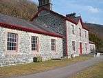
|
| Western Slab Mill at Felin Fawr Slate Works | Llandygai | 4 November 1990 | SH6148166361 53°10′35″N 4°04′26″W / 53.176282751175°N 4.074025126854°W |
Slab Mill | Situated on the western side of the Felin Fawr Slate Works, which adjoin the former Penrhyn Quarry Railway and the west bank of the Afon Galedffrwd. | 4153 |
|
| Water Wheel House between slab mills at Felin Fawr Slate Works | Llandygai | 4 November 1990 | SH6149366362 53°10′35″N 4°04′26″W / 53.176294864353°N 4.0738461413347°W |
Water wheel house | Located between the slab mills at Felin Fawr Slate Works. | 4154 |
|
| Eastern Slab Mill at Felin Fawr Slate Works | Llandygai | 4 November 1990 | SH6150566367 53°10′35″N 4°04′25″W / 53.176342909194°N 4.0736688893477°W |
Located in the centre of yard at the Felin Fawr Slate Works, which adjoin the former Penrhyn Slate Quarry Railway and the west bank of the Afon Galedffrwd. | 4155 |
| |
| Tanyrallt, Glanrafon Hill | Bangor | 11 September 1987 | SH5783072107 53°13′37″N 4°07′52″W / 53.226931923422°N 4.1311719454088°W |
On steeply sloping ground below the bend in the road; set amongst modern University buildings. | 4163 |
| |
| The Best Stables on S side of Vaynol Old Hall and courtyard walls. | Pentir | 26 August 1992 | SH5382069521 53°12′09″N 4°11′24″W / 53.202613010467°N 4.1900087682056°W |
Stables | The stables are set in the heart of Vaynol Park, attached to buildings at the W end of Vaynol Old Hall. They close the E side of the enclosed cobbled courtyard which opens from the main driveway to Vaynol Hall. | 4167 |
|
| Terraced Garden to N of Vaynol Old Hall | Pentir | 26 August 1992 | SH5384569562 53°12′11″N 4°11′23″W / 53.20298817228°N 4.1896535588989°W |
Terracing | Laid out immediately N of the front driveway to Vaynol Old Hall. Its N end borders the walled garden to the rear of Dairy Cottage. | 4169 |
|
| Gateway with inscription set in N boundary wall of Terrace Garden opposite Vaynol Old Hall | Pentir | 3 March 1966 | SH5383069566 53°12′11″N 4°11′24″W / 53.203019967995°N 4.1898797875998°W |
Gateway | Set in the heart of Vaynol Park, at the N end of the Terraced Garden opposite the N front of Vaynol Old Hall. | 4170 |
|
| Long Barn at Vaynol Farm | Pentir | 3 March 1966 | SH5378069640 53°12′13″N 4°11′26″W / 53.203670874101°N 4.1906616888688°W |
Barn | The long barn stands at the centre of the Vaynol Farm buildings, the gable end facing the E approach drive. The farm lies to the N of Vaynol Old Hall. | 4184 |
|
| Bodwrdda | Aberdaron | 19 January 1952 | SH1887427194 52°48′42″N 4°41′20″W / 52.811770030312°N 4.6888882406649°W |
Situated in Daron valley, down long drive running E and S from B4413 from junction 2 km SW of Rhoshirwaun. | 4209 |
| |
| Plas yn Rhiw | Aberdaron | 19 January 1952 | SH2361828228 52°49′21″N 4°37′09″W / 52.822632697061°N 4.619139358686°W |
Manor house | Situated some 1.1 km ENE of Rhiw, just off the road to Porth Neigwl. | 4210 | 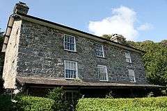
|
| Wern Fawr | Llanbedrog | 19 January 1952 | SH3231733414 52°52′19″N 4°29′34″W / 52.871991738921°N 4.4928419324872°W |
Farmhouse | The farmhouse lies on a former trackway leading off the minor road from Llanbedrog to Rhyd-y-clafdy, at the N end of the community. | 4214 |
|
| Castellmarch | Llanengan | 19 January 1952 | SH3144329726 52°50′19″N 4°30′14″W / 52.838596882343°N 4.50390589647°W |
Situated down drive running W from A499 from point some 1.5 km N of Abersoch. | 4215 |
| |
| Bodfel | Llannor | 19 January 1952 | SH3413736961 52°54′16″N 4°28′03″W / 52.904412867857°N 4.4676378044748°W |
Bodfel stands to the NW of Efailnewydd, approached by a minor road running due N, approximately 400m N of Pont Bodfel. | 4216 |
| |
| Plas Bodegroes | Llannor | 19 January 1952 | SH3548235283 52°53′23″N 4°26′49″W / 52.889757130405°N 4.4468096919934°W |
Restaurant | The house stands in its own parkland and gardens, reached by a driveway from Bodegroes Lodge on the main road from Pwllheli to the NW. | 4217 | 
|
| Cefnamwlch | Tudweiliog | 19 January 1952 | SH2341535272 52°53′09″N 4°37′33″W / 52.885820558608°N 4.6259664347472°W |
Situated in the centre of wooded parkland approximately 1.5 km S of the centre of Tudweiliog. The main approach drive of some 1.2 km runs SW from the Lower Lodge entrance off a minor road from Tudweiliog. | 4222 |
| |
| Bryn Nodol | Bryn Odol, Tudweiliog | 19 January 1952 | SH2506836495 52°53′50″N 4°36′08″W / 52.897344918974°N 4.6020844002308°W |
Holiday homes | Situated approximately 1.4 km SE of the centre of Tudweiliog, approached by a 350m drive off the road to Dinas. | 4223 | .jpg)
|
| Ty'n-y-graig | Aberdaron | 19 October 1971 | SH2353228540 52°49′31″N 4°37′14″W / 52.825406222436°N 4.6205829202755°W |
House | On the NE side of a lane running past Plas-yn-Rhiw to the Church of St Aelrhiw, some 1km E of Rhiw village. | 4240 | 
|
| Church of St Mary | Botwnnog | 19 October 1971 | SH2262231481 52°51′05″N 4°38′08″W / 52.851516400344°N 4.6356732422802°W |
Church | In a raised churchyard on the N side of the minor road leading NW from the centre of Bryncroes village to the B 4413. | 4254 | 
|
| Nanhoron | Botwnnog | 19 October 1971 | SH2805031477 52°51′12″N 4°33′19″W / 52.85324632277°N 4.5551492045747°W |
House | Approximately 1.69km E of Botwnnog, reached along a private drive some 150m S from the B4413, surrounded by the estate park to the S and a walled vegetable and flower garden to the N. | 4261 | 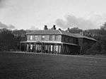
|
| Church of St Tudwen | Llandudwen, Buan | 19 October 1971 | SH2740636863 52°54′05″N 4°34′03″W / 52.901407553456°N 4.5675602363337°W |
Church | Situated in isolated walled churchyard by Llandudwen farm, approached by drive running N off lane about 1.3 km W of Madryn Castle. | 4266 | 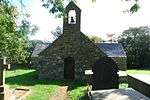
|
| Penhyddgan | Buan | 19 October 1971 | SH3024038670 52°55′07″N 4°31′35″W / 52.918540463027°N 4.5264143663979°W |
Situated some 2 km E of Ceidio church and approached by drive running SW from the A497 NW of Boduan. | 4269 |
| |
| Saethon Old Farmhouse | Llanengan | 19 October 1971 | SH2949332742 52°51′54″N 4°32′04″W / 52.865066901508°N 4.5344038173824°W |
Farmhouse | Situated some 600m down drive running NW from point some 1.4km NE of Capel Nant on road to Rhydyclafdy. | 4275 |
|
| Parish Church of St Mary | Dolbenmaen | 19 October 1971 | SH5067043150 52°57′54″N 4°13′30″W / 52.964866141115°N 4.224875651556°W |
Church | The parish church lies on a small by-passed section of the main road at the junction with the Cwm Pennant road. It stands within an irregularly shaped graveyard and is approached through a lych gate. | 4278 | .jpg)
|
| Church of St Cynhaearn | Dolbenmaen | 19 October 1971 | SH5258338787 52°55′34″N 4°11′40″W / 52.926205521392°N 4.1944301221369°W |
Disused church | The church stands alone on the former island in Llyn Ystumllyn, approx 900m S of Pentrefelin, and is reached by a track from the village. | 4291 | 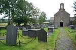
|
| Church of St Aelhaearn | Llanaelhaearn | 19 October 1971 | SH3870344815 52°58′35″N 4°24′13″W / 52.976345636626°N 4.4037214080127°W |
Church | The church stands in the centre of a large irregular churchyard at the centre of the village, bounded by the road on the S and W. | 4293 | 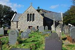
|
| Church of St Pedrog | Llanbedrog | 19 October 1971 | SH3294531553 52°51′20″N 4°28′57″W / 52.855474176206°N 4.482566030102°W |
Church | The church is located on the first level ground above the beach, at the lower end of Llanbedrog, and close to the small stream with defines the churchyard on the SE. | 4297 | 
|
| Church of the Holy Cross | Llannor | 19 October 1971 | SH3539237264 52°54′27″N 4°26′57″W / 52.907521017921°N 4.4491496771734°W |
Church | The parish church stands at the centre of the village, within an oval churchyard. | 4322 | 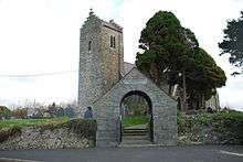
|
| Llwyndyrus | Llannor | 19 October 1971 | SH3862340834 52°56′26″N 4°24′11″W / 52.940567019374°N 4.4029274762853°W |
Farmhouse | The farmhouse stands back from the road running NW from Y Ffor. | 4323 |
|
| Plas-gwyn | Llannor | 19 October 1971 | SH3956738422 52°55′09″N 4°23′16″W / 52.919187551979°N 4.3876998573627°W |
Farmhouse | Plas-gwyn lies off the main Pwllheli to Caernarfon road, approximately 700m S of Y Ffor crossroads. | 4327 | 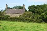
|
| Church of St Garmon | Llanarmon, Llanystumdwy | 19 October 1971 | SH4231639351 52°55′42″N 4°20′50″W / 52.928347672939°N 4.3473010813708°W |
Church | The church is set in an elevated oval churchyard at the centre of the hamlet of Llanarmon. | 4337 | 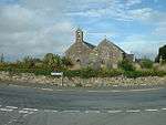
|
| Church of St Cybi | Llangybi, Llanystumdwy | 19 October 1971 | SH4285641171 52°56′41″N 4°20′25″W / 52.944853128084°N 4.3401571153138°W |
Church | The parish church stands in its churchyard at the centre of the village of Llangybi. | 4342 | 
|
| Highgate | Llanystumdwy | 19 October 1971 | SH4753338416 52°55′17″N 4°16′10″W / 52.921459755949°N 4.2693164178313°W |
House | Lloyd George's House. The house is in a row on the NE side of the main street, E of the bridge. | 4355 | 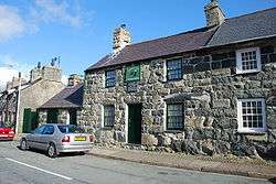
|
| Ty-newydd | Llanystumdwy | 19 October 1971 | SH4788838426 52°55′18″N 4°15′51″W / 52.921650479113°N 4.2640451758537°W |
House | The house is reached from a drive off the road leading W of the village centre, past Lloyd George's grave. | 4357 | 
|
| Plas-du | Llanarmon, Llanystumdwy | 19 October 1971 | SH4116540322 52°56′12″N 4°21′54″W / 52.936728694268°N 4.3648841655612°W |
Farmhouse | The farm lies to the S of the village of Pencaenewydd, SW of the former turnpike road to Porthdinllaen. | 4361 | 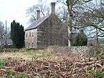
|
| Church of St Mary | Penllech, Tudweiliog | 19 October 1971 | SH2199334399 52°52′39″N 4°38′48″W / 52.877511104192°N 4.6465988405598°W |
Disused church | Situated some 100m S of Plas-ym-Mhenllech at Penllech. | 4380 | 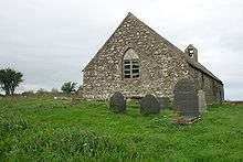
|
| Church of St. Catherine, Lon Ednyfed | Lon Ednyfed, Criccieth | 8 February 1949 | SH5007838337 52°55′17″N 4°13′53″W / 52.921468295836°N 4.2314560022742°W |
Church | 4395 | _Church%2C_Lon_Ednyfed_(geograph_1782414).jpg)
| |
| Plas Tan-yr-allt | Porthmadog | 30 March 1951 | SH5662940456 52°56′32″N 4°08′06″W / 52.942296136656°N 4.1350260860649°W |
Country house hotel | In its own grounds and reached by private drive on the N side of the A498, approximately 0.5km NE of Tremadog Market Square. | 4432 | 
|
| Church of St Mary | Tremadog, Porthmadog | 30 March 1951 | SH5626140065 52°56′19″N 4°08′25″W / 52.938685145389°N 4.1403248831591°W |
Church | Sited on an eminence in a large churchyard, to the South of the Market Square. | 4435 | 
|
| Ty Nanney, including forecourt walls, gate piers and gate | Porthmadog | 30 March 1951 | SH5624439962 52°56′16″N 4°08′26″W / 52.937755337773°N 4.1405319707951°W |
House | Set back from the road in its own grounds, just S of the junction of Church Street (A487) and Isgraig. | 4441 | 
|
| Tremadog Manufactory | Porthmadog | 30 March 1951 | SH5638440317 52°56′28″N 4°08′19″W / 52.940981851629°N 4.1386076767496°W |
Workshop | Set back on the N side of the A498 approximately 500m ENE of Tremadog Market Square. | 4449 |
|
| Market Hall | Tremadog, Porthmadog | 30 March 1951 | SH5617140190 52°56′23″N 4°08′30″W / 52.93978385075°N 4.1417185581806°W |
Shop (Siola clothing) | Prominently sited on the N side of Market Square, set back from the road and raised above street level. | 4452 | 
|
| Glasfryn House | Llanystumdwy | 15 June 1978 | SH4021042578 52°57′24″N 4°22′49″W / 52.956706716397°N 4.3801936716935°W |
House | The house is near the N boundary of the community, and is reached by a long driveway off the road running N of Pencaenewydd towards its junction with the A499. | 4607 |
|
| Hovel at Tan-y-bwlch | Clynnog | 18 May 1989 | SH4313448780 53°00′48″N 4°20′23″W / 53.01327626681°N 4.3397147249016°W |
Cottage | The structure stands in the garden of Tan-y-bwlch, a farm on the N side of the road skirting the north side of Bwlch Mawr and running towards Pencaenewydd. | 4618 |
|
| Church of St Beuno | Penmorfa, Dolbenmaen | 19 October 1971 | SH5413040295 52°56′25″N 4°10′20″W / 52.940174985129°N 4.1721135304102°W |
Church | Located on the end of an old road leading SW from the W end of Penmorfa village. | 4623 | 
|
| Moriah Methodist Chapel | Llanystumdwy | 24 October 1991 | SH4746538434 52°55′18″N 4°16′13″W / 52.921602081113°N 4.2703354771613°W |
Chapel | The building is located at the centre of the village, set back from and below the road; opposite the Lloyd George Memorial Museum. The lawned churchyard has a low rubble boundary wall to the road. | 4624 | 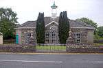
|
| Wern Manor | Dolbenmaen | 15 June 1993 | SH5427739927 52°56′13″N 4°10′11″W / 52.936909343524°N 4.1697623125227°W |
Manor house | The manor is set in its own grounds, some 2km W of Tremadoc and S of Penmorfa village, and can be reached by the private driveway from the main road. | 4626 |
|
| Dolaugwyn | Bryn Crug | 30 March 1951 | SH6230803464 52°36′41″N 4°02′06″W / 52.611459100575°N 4.0350068951273°W |
Farmhouse | The farm is on flat land of the lower Afon Fathew valley, to the W of Bryn Crug village. The farmhouse stands apart to the W of the farm buildings. | 4632 |
|
| Hen Dyffryn Gwyn | Tywyn | 30 March 1951 | SN6324298323 52°33′56″N 4°01′09″W / 52.565507928867°N 4.019097074471°W |
House | Set back on the S side of the minor road through Cwm Maethlon, approximately 5.1km SE of Tywyn. | 4633 | .jpg)
|
| Crogen | Llandderfel | 12 June 1951 | SJ0063737010 52°55′17″N 3°28′46″W / 52.921303214539°N 3.4793561281791°W |
House | Located at the eastern boundary of the community within its own grounds; set back from the road and accessed via lodged drives. | 4650 |
|
| Henblas including adjoining Barn Range | Llandderfel | 6 December 1951 | SH9885737804 52°55′41″N 3°30′22″W / 52.928105373749°N 3.506069272463°W |
House | Located approximately 800m NE of Llandderfel village and accessed via a farm track running N from an unclassified road running NE from the village. | 4651 |
|
| Plas Rhiwaedog | Llangywer | 12 June 1951 | SH9471134806 52°54′01″N 3°34′00″W / 52.900367208583°N 3.5667482090325°W |
Hall | Located at the end of a private driveway that leads NE from the country road at Pont Rhiwaedog; c. 400m ENE of the village of Rhos-y-gwaliau. | 4652 | 
|
| Pont Fawr | Llandderfel | 20 October 1966 | SH9819436597 52°55′02″N 3°30′56″W / 52.917133607369°N 3.5155494722943°W |
Bridge | Spanning the River Dee approximately 0.5km S of Llandderfel village, and carrying the Bala – Corwen road. | 4658 | 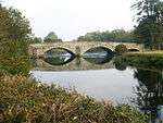
|
| Gwern-y-braichdwr | Llandderfel | 20 October 1966 | SH9972042214 52°58′04″N 3°29′41″W / 52.967896544443°N 3.4946017647663°W |
Farmhouse | Located on the southern slope of the Cwm Main, at the eastern end; accessed via a track running from a lane itself running W from Glan-yr-Afon | 4660 |
|
| Capel Ainon | Llanuwchllyn | 20 October 1966 | SH8699629774 52°51′13″N 3°40′47″W / 52.853582843098°N 3.6796441123282°W |
Chapel | Located approximately 1km SW of Llanuwchllyn village, set back slightly from the road within its own low-walled graveyard. | 4679 |
|
| Caer Gai, including adjoining forecourt walls to the NE | Llanuwchllyn | 20 October 1966 | SH8773531493 52°52′09″N 3°40′09″W / 52.869183880348°N 3.6692673782614°W |
House | Located approximately 2km N of Llanuwchllyn village within the site of the Roman fort; accessed via a track running N from the main road. | 4683 |
|
| Pont Dol-y-Moch | Ffestiniog | 24 April 1951 | SH6849441648 52°57′22″N 3°57′33″W / 52.956050237707°N 3.9590589633978°W |
Bridge | Spanning the Afon Dwyryd about 1km SE of Rhyd-y-sarn at the SW boundary of this community area with that of Maentwrog. | 4694 | .jpg)
|
| Pengwern Old Hall | Ffestiniog | 24 April 1951 | SH6991943045 52°58′08″N 3°56′18″W / 52.968949136901°N 3.9384211987306°W |
Hall | Located on a rise overlooking the Ceunant Sych approximately 2km N of Ffestiniog; accessed via a farm track leading W off an unclassified lane connecting the A 470 with the A 496. | 4699 |
|
| Plas Tan-y-Bwlch including attached terrace walls to east and west | Tan-y-Bwlch, Maentwrog | 24 April 1951 | SH6555040630 52°56′46″N 4°00′09″W / 52.946173469824°N 4.0024319771286°W |
Study centre | In an elevated location, set within private grounds above the NW side of the A487(T) on the W approach to the village of Maentwrog. | 4702 | 
|
| Cors y Gedol Hall | Dyffryn Ardudwy | 14 June 1952 | SH6001123079 52°47′14″N 4°04′38″W / 52.787086164471°N 4.0772605404223°W |
In private grounds set well back from the ENE side of the A496 between Dyffryn Ardudwy and Tal-y-bont. The hall is located at the head of a driveway (Ffordd Gors) leading ENE out of the small hamlet of Llanddwywe. | 4709 | 
| |
| Nannau | Brithdir and Llanfachreth | 14 June 1952 | SH7430720814 52°46′13″N 3°51′52″W / 52.770262189187°N 3.8645326383865°W |
4710 | .jpg)
| ||
| Cae'r Berllan | Llanfihangel y Pennant | 14 June 1952 | SH6630707772 52°39′04″N 3°58′40″W / 52.651164926993°N 3.97772984965°W |
Farmhouse | The farmhouse stands back from the farm buildings, facing the W. | 4711 |
|
| Lychgate at St. Paul's Church | Brithdir and Llanfachreth | 17 June 1966 | SH7967320765 52°46′16″N 3°47′06″W / 52.771046651919°N 3.7850199678601°W |
Lychgate | 4713 |
| |
| Plas Hen | Brithdir and Llanfachreth | 17 June 1966 | SH7656817735 52°44′35″N 3°49′48″W / 52.743120167496°N 3.8298774744996°W |
4714 | 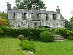
| ||
| Egryn Abbey | Tal-y-bont, Dyffryn Ardudwy | 17 June 1966 | SH5951820327 52°45′44″N 4°05′00″W / 52.762235093473°N 4.0833843424007°W |
Farmhouse | Set back from the NE side of the A496, c. 1.5km SSE of Tal-y-bont. The house and associated farm buildings are reached by a private track. | 4717 | 
|
| Church of St. Dwywe | Dyffryn Ardudwy | 17 June 1966 | SH5864122334 52°46′48″N 4°05′50″W / 52.780035619125°N 4.0972387332637°W |
Church | Within a churchyard to the W side of the A496 in the small hamlet of Llanddwywe. | 4718 | .jpg)
|
| Corn barn at Cors y Gedol Hall | Dyffryn Ardudwy | 17 June 1966 | SH6007123077 52°47′14″N 4°04′35″W / 52.787083791165°N 4.0763706168626°W |
Barn | Cors y Gedol is ENE of Llanddwywe. The corn barn lies to E of the hall. | 4720 |
|
| Gatehouse at Cors y Gedol Hall | Dyffryn Ardudwy | 17 June 1966 | SH6002423044 52°47′12″N 4°04′37″W / 52.786775119245°N 4.0770529279631°W |
Gatehouse | In private grounds set well back from the ENE side of the A496 between Dyffryn Ardudwy and Tal-y-bont. Located at the head of a driveway (Ffordd Gors) leading ENE out of the small hamlet of Llanddwywe. The gatehouse is directly S of the hall. | 4722 | 
|
| Peniarth | Llanegryn | 17 June 1966 | SH6121505401 52°37′43″N 4°03′07″W / 52.628582225781°N 4.0519521500535°W |
House | The Peniarth Estate occupies a considerable tract of land on the N bank of the Afon Dysynni, E of Llanegryn village. The house stands towards the S edge of the parkland, overlooking the river and the valley to the S. | 4731 | 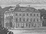
|
| Parish Church of St Illtyd including churchyard walls and gatepiers | Llanelltyd | 17 June 1966 | SH7175319546 52°45′30″N 3°54′07″W / 52.758268085897°N 3.9018702036027°W |
Church | Set back slightly from the main road on a slight rise; set within its own circular, walled churchyard. | 4737 | 
|
| Ty Fanner | Llanelltyd | 17 June 1966 | SH7208919546 52°45′30″N 3°53′49″W / 52.758347903048°N 3.8968941721405°W |
Located immediately to the W of Cymer Abbey ruins; accessed via a lane running NE from the main road. | 4739 |
| |
| Pont Llanelltyd | Llanelltyd | 17 June 1966 | SH7180219320 52°45′22″N 3°54′04″W / 52.756249227668°N 3.9010560840831°W |
Bridge | A 470 (NE side), Llanelltyd | 4741 | 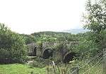
|
| Church of St Michael | Llanfihandel-y-Pennant | 17 June 1966 | SH6714408863 52°39′40″N 3°57′57″W / 52.661172992516°N 3.965804869863°W |
Church | The parish church stands on the valley floor of the upper Dysynni valley, within its own sub-oval churchyard. | 4747 | 
|
| Front garden walls, gate piers and mounting block at Cae'r Berllan | Llanfihangel-y-Pennant | 17 June 1966 | SH6629707791 52°39′05″N 3°58′40″W / 52.651333158638°N 3.9778852833314°W |
The front garden walls define the raised rectangular garden in front of the main NW elevation of Cae'r Berllan. | 4750 |
| |
| Church of St Tydecho | Mallwyd, Mawddwy | 17 June 1966 | SH8628712359 52°41′49″N 3°41′03″W / 52.696949226504°N 3.6841154107117°W |
Church | The church stands at the S end of the village of Mallwyd, which is by-passed by the present A470. | 4756 | .jpg)
|
| Cefn-caer | Pennal | 17 June 1966 | SH7042100120 52°35′00″N 3°54′50″W / 52.583414616196°N 3.9139509398954°W |
Farmhouse | The farmhouse is located c400m SE opf the village, in an elevated position on the NW side of the defences of the Roman fort. The farmyard lies further to the SW of the house. | 4761 | 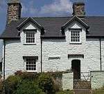
|
| Church of St Mary | Tal-y-Llyn, Llanfihangel-y-Pennant | 17 June 1966 | SH7106109406 52°40′01″N 3°54′29″W / 52.666999357978°N 3.9081374943102°W |
Church | The church stands at Tal-y-Llyn, beside the road from Minffordd to Abergynolwyn, at the S end of Tal-y-Llyn lake. | 4762 | 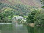
|
| Parc | Llanfrothen | 28 April 1952 | SH6268543958 52°58′31″N 4°02′47″W / 52.975343428026°N 4.0464534583606°W |
House | Strikingly located on an elevated site above the Afon Maesgwm, approximately 2km SW of Croesor; accessed via a long drive running SW from the Garreg to Croesor road. | 4773 |
|
| Glyn Cywarch | Talsarnau | 28 April 1952 | SH6085434284 52°53′17″N 4°04′10″W / 52.887965154011°N 4.0695511005569°W |
In private grounds set well back from the NE side of the B4573, to S of Glan-y-wern and SE of Eisingrug. | 4778 |
| |
| Church of St Peter | Llanbedr | 30 November 1966 | SH5849826979 52°49′18″N 4°06′05″W / 52.821725968434°N 4.1013688287635°W |
Church | Within a subrectangular churchyard set well back from the NE side of the A496 at the N end of the village of Llanbedr. | 4782 |
|
| Church of St Mary | Llanfair | 30 November 1966 | SH5776029070 52°50′25″N 4°06′48″W / 52.840315341155°N 4.113224667144°W |
Church | Within the churchyard to NE of the main road through the village of Llanfair which forms a loop off the A496. | 4794 | 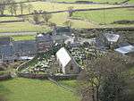
|
| Llanfair-Isaf Farmhouse | Llanfair | 30 November 1966 | SH5754128859 52°50′18″N 4°06′59″W / 52.838361872685°N 4.1163814487839°W |
Set back from the W side of the A496. | 4796 |
| |
| Plas Brondanw | Garreg, Llanfrothen | 30 November 1966 | SH6164242285 52°57′36″N 4°03′41″W / 52.960045479724°N 4.061260224895°W |
House | On a commanding, sloping site overlooking the Traeth Mawr 0.5km NE of Garreg village; backing onto a lane running NE from Garreg to Croesor and parallel with the A 4085. Set within its own gardens of national importance. Home of Clough Williams-Ellis. | 4808 | 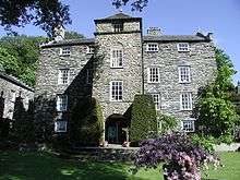
|
| L-shaped Agricultural Range at Parc | Llanfrothen | 30 November 1966 | SH6264143955 52°58′31″N 4°02′50″W / 52.975305180394°N 4.0471070090864°W |
farm building | Located immediately to the W of Parc, facing a farmyard to the N. | 4816 |
|
| Middle Parc including Fountain Basin adjoining to W | Llanfrothen | 30 November 1966 | SH6271343964 52°58′31″N 4°02′46″W / 52.975404516009°N 4.0460392985143°W |
House | Strikingly located on an elevated site above the Afon Maesgwm, approximately 2km SW of Croesor; sited some 50m NE of Parc. | 4817 |
|
| Gattws Parc including Boulder Wall adjoining to NW | Llanfrothen | 30 November 1966 | SH6281744025 52°58′34″N 4°02′40″W / 52.975979189588°N 4.0445174033819°W |
House | Strikingly located on an elevated site above the Afon Maesgwm, approximately 2km SW of Croesor; sited into the hillslope immediately to the NW of the old approach road to Parc, approximately 200m NE of Parc. | 4818 |
|
| Gatehouse at Glyn Cywarch | Talsarnau | 30 November 1966 | SH6090034260 52°53′16″N 4°04′08″W / 52.887761478278°N 4.0688576277579°W |
Gatehouse | In private grounds set well back from the NE side of the B4573, to S of Glan-y-wern and SE of Eisingrug; the gatehouse is directly SE of the house at Glyn Cywarch. | 4844 |
|
| Plas Penrhyn | Penrhyndeudraeth | 14 January 1971 | SH5905137922 52°55′13″N 4°05′52″W / 52.920175666563°N 4.0979081925468°W |
House | Located towards the western boundary of the community on a commanding, elevated site overlooking Porthmadog and the Traeth Mawr; accessed via a lane running SW from the main road (A 487). | 4852 |
|
| Campanile (also called The Bell Tower) | Penrhyndeudraeth | 14 January 1971 | SH5898937141 52°54′47″N 4°05′55″W / 52.913143451011°N 4.0984903385288°W |
Bell tower | Prominently sited on the south-eastern ridge overlooking the village and hotel. | 4868 |
|
| The Colonnade | Penrhyndeudraeth | 14 January 1971 | SH5897937179 52°54′49″N 4°05′55″W / 52.91348218353°N 4.0986554538452°W |
Colonnade | Overlooking the Central Piazza to the E. | 4878 |
|
| Ty Gwyn with Davy Jones' Locker Cafe | Barmouth | 4 March 1951 | SH6151015495 52°43′10″N 4°03′07″W / 52.71934105367°N 4.0518429885742°W |
House/Cafe | Harbour Street (E side), Barmouth Harbour | 4897 | 
|
| Aykroyd & Sons, Clothing Factory (Former Workhouse) | Bala | 19 October 1951 | SH9252135857 52°54′34″N 3°35′59″W / 52.909377027483°N 3.5996404862201°W |
Fronting the street towards the SW end of the town. | 4913 |
| |
| Llwyn | Dolgellau | 19 June 1990 | SH7324218132 52°44′45″N 3°52′45″W / 52.745915865139°N 3.8792714782199°W |
Bala Road | 4924 |
| |
| Plas Gwyn | Dolgellau | 19 June 1990 | SH7273017686 52°44′30″N 3°53′12″W / 52.741788148407°N 3.8866787606841°W |
House | Finsbury Square | 4989 |
|
| Tan-y-Fynwent | Dolgellau | 2 December 1952 | SH7270017809 52°44′34″N 3°53′14″W / 52.742886183345°N 3.8871706439774°W |
Marian Road | 5033 |
| |
| T.H.Roberts shop | Dolgellau | 19 June 1990 | SH7282617841 52°44′36″N 3°53′07″W / 52.743203410537°N 3.8853176896871°W |
Shop | Ironmonger, Queen's Square (E Side) | 5059 | .jpg)
|
| County Hall, | Dolgellau | 2 December 1952 | SH7286917938 52°44′39″N 3°53′05″W / 52.744085058627°N 3.884718708049°W |
Courthouse | Smithfield Street | 5073 | 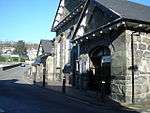
|
| Bryn-y-Gwin Uchaf | Dolgellau | 19 June 1990 | SH7202417791 52°44′33″N 3°53′50″W / 52.742564519111°N 3.8971714079549°W |
House | Towyn Road | 5115 | 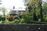
|
| Dolgun Isaf Farmhouse | Dolgellau | 19 June 1990 | SH7447118224 52°44′49″N 3°51′40″W / 52.74702987028°N 3.8611104920955°W |
Farmhouse | A470 (N. side) | 5123 |
|
| Dolgun Uchaf | Dolgellau | 17 June 1966 | SH7469518376 52°44′54″N 3°51′28″W / 52.748447642779°N 3.8578520313159°W |
A470 (N. side) | 5125 |
| |
| Barn at Dolgun Uchaf | Dolgellau | 17 June 1966 | SH7469018386 52°44′55″N 3°51′29″W / 52.748536329172°N 3.8579298881016°W |
Barn | A470 (N.side) | 5126 |
|
| Byre at Dolgun Uchaf | Dolgellau | 17 June 1966 | SH7470718385 52°44′55″N 3°51′28″W / 52.748531293643°N 3.8576777926136°W |
Byre | A470 (N.SIDE) | 5127 |
|
| Gazebo or Music Room at Dolrhyd | Dolgellau | 23 November 1987 | SH7164018445 52°44′54″N 3°54′11″W / 52.74834919766°N 3.9031123434849°W |
Gazebo | A470 (N.side) | 5129 |
|
| Garth Maelan | Dolgellau | 19 June 1990 | SH7430318894 52°45′11″N 3°51′50″W / 52.753010541459°N 3.863854915314°W |
Road to Llanfachreth | 5134 |
| |
| Bryn-y-Gwin (Bryn-y-Gwin Isaf) | Dolgellau | 17 June 1966 | SH7169717820 52°44′34″N 3°54′07″W / 52.742747400214°N 3.9020237518603°W |
Towyn Road | 5165 |
| |
| Cae'r March | Brithdir and Llanfachreth | 20 March 1975 | SH7613421832 52°46′47″N 3°50′16″W / 52.779831772652°N 3.8378525543355°W |
5188 |
| ||
| Barmouth Railway Bridge | Barmouth | 22 March 1988 | SH6196315486 52°43′10″N 4°02′42″W / 52.719376219665°N 4.0451370206302°W |
Bridge | (partly in Arthog community) | 5207 | 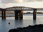
|
| Yr Ysgrwyn Farmhouse, stable and cartshed | Trawsfynydd | 10 June 1989 | SH7229634668 52°53′39″N 3°53′59″W / 52.894260285412°N 3.8997482345468°W |
Farmhouse | Sited on rising ground on the S side of Cwm Prysor and reached via a farm track off the road from Trawsfynydd. | 5217 | 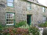
|
| Dower House at Llwyndu | Barmouth | 27 November 1986 | SH6000618535 52°44′47″N 4°04′31″W / 52.746263428642°N 4.0753917213415°W |
Dower House | A 496 (E. side) Llanaber | 5229 |
|
| The Cob | Penrhyndeudraeth | 22 February 1991 | SH5802138037 52°55′15″N 4°06′48″W / 52.920936847949°N 4.1132672689753°W |
Causeway | The Cob crosses the Traeth Mawr and the mouth of the Afon Glaslyn in Tremadoc Bay estuary and carries both the A487 and the Ffestiniog Railway from Boston Lodge to Porthmadoc. Spans District and Community boundaries. | 5234 | 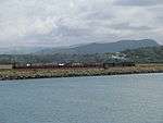
|
| The Cruck Hall at Rhowniar Outward Bound Centre | Aberdovey | 12 October 1991 | SN5973098258 52°33′51″N 4°04′15″W / 52.564027856335°N 4.0708475177958°W |
Hall | A493 (E dide), Rhowniar | 5240 |
|
| Plas Mynach | Barmouth | 25 February 1992 | SH6080716611 52°43′45″N 4°03′46″W / 52.729186098513°N 4.0627171175532°W |
House | A 496, Hendremynach | 5244 | 
|
| The New Lodge | Plas Bronanw, Llanfrothen | 27 October 1992 | SH6142042045 52°57′28″N 4°03′52″W / 52.957832032949°N 4.0644601676039°W |
House | Approximately 0.4km SW of Plas Brondanw at the junction with the by-road to Croesor. Set back and at a splayed angle, with ball finial to forecourt wall. | 5248 | .jpg)
|
| St. Philip's Church | Caerdeon, Barmouth | 11 September 1992 | SH6512418138 52°44′38″N 3°59′58″W / 52.744000984861°N 3.9994587990679°W |
Church | A496 (N side) Caerdeon | 5249 | 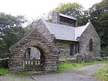
|
| Dock, perimeter wall and attached buildings to east of Fort Belan | Llandwrog | 23 February 1994 | SH4415860928 53°07′22″N 4°19′49″W / 53.122684718265°N 4.3303503888172°W |
Dock | Situated at water edge directly to east of Fort Belan. | 14409 |
|
| Bryn Dinas | Tywyn | 7 December 1994 | SN6350798583 52°34′04″N 4°00′55″W / 52.567910525604°N 4.0152971508103°W |
House | Reached by a short farm road on the N side of the minor road through Cwm Maethlon, approximately 5.3km SE of Tywyn. | 14552 |
|
| Bryntirion | Pentir | 3 March 1966 | SH5313668651 53°11′41″N 4°11′59″W / 53.194609549157°N 4.1998407316847°W |
House | Bryntirion lies near the S end of Vaynol Park and is reached by a drive entered from the main road at Aber Pwll which climbs up through Bryntirion Lodge Wood to the sloping site of Bryntirion and its outbuildings. | 14924 | 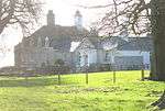
|
| Cefndeuddwr Farmhouse | Ganllwyd | 13 February 1995 | SH7300726070 52°49′02″N 3°53′09″W / 52.817180453857°N 3.8858327336262°W |
Farmhouse | A470 (E side), Cefndeuddwr | 15156 |
|
| Ystumllyn | Criccieth | 12 December 1994 | SH5186238784 52°55′34″N 4°12′19″W / 52.925979699718°N 4.2051457145194°W |
Ffordd Porthmadog (Porthmadoc Road) (SE side) | 15355 |
| |
| Former Stables | Criccieth | 12 December 1994 | SH5187138801 52°55′34″N 4°12′18″W / 52.926134892218°N 4.2050197027278°W |
Stables | Ffordd Porthmadog (Porthmadoc Road) (SE side) | 15356 |
|
| Wash House | Criccieth | 12 December 1994 | SH5185038794 52°55′34″N 4°12′19″W / 52.926066207423°N 4.2053286490966°W |
Wash house | Ffordd Porthmadog (Porthmadoc Road) (SE side) | 15357 |
|
| Morris and Co., General Cambrian Establishment | Barmouth | 31 January 1995 | SH6141015710 52°43′16″N 4°03′12″W / 52.721246906081°N 4.0534132522468°W |
(Former Drapers' Shop) High Street (SW side), Barmouth | 15464 |
| |
| Glan Glasfor to the rear of Morris and Co. | Barmouth | 31 January 1995 | SH5000050000 53°01′34″N 4°14′17″W / 53.026207414394°N 4.2380240295533°W |
High Street (SW side), Barmouth | 15465 |
| |
| St. John's Church | Barmouth | 31 January 1995 | SH6132715942 52°43′24″N 4°03′17″W / 52.723309827644°N 4.0547392989796°W |
Church | St. Johns's Hill, Barmouth | 15467 | 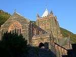
|
| Plas Canol | Barmouth | 31 January 1995 | SH5988918970 52°45′01″N 4°04′38″W / 52.750140917221°N 4.0773097304044°W |
House | Situated on a hill to the E of the main road, and reached via a long farm track; about 1km N of Llanaber. | 15503 |
|
| Former Farmhouse at Cefn-yr-Owen-Uchaf | Arthog | 2 January 1995 | SH6828015069 52°43′02″N 3°57′05″W / 52.717207988136°N 3.9515044915331°W |
Farmhouse | Ffordd Ddu (N side) Cefn-yr-Owen-Uchaf | 15593 |
|
| Garth Isaf Farmhouse | Arthog | 2 January 1995 | SH6537415996 52°43′29″N 3°59′42″W / 52.724819511428°N 3.9948787062977°W |
Farmhouse | Located 0.5km NW of the main road in a hollow near the estuary and accessed via a long wooded track; raised up behind a dwarf-walled terrace, its E gable facing the former, disused road. | 15598 |
|
| Hafod Dywyll Farmhouse, Kings | Arthog | 20 March 1975 | SH6857515948 52°43′31″N 3°56′51″W / 52.725177138299°N 3.9474918003767°W |
Farmhouse | 15606 |
| |
| Braich-y-Ceunant | Brithdir and Llanfachreth | 26 May 1995 | SH7634118154 52°44′49″N 3°50′00″W / 52.746832868922°N 3.8333962862476°W |
16013 |
| ||
| Ty Cerrig | Brithdir and Llanfachreth | 26 May 1995 | SH7688720802 52°46′15″N 3°49′35″W / 52.770749898959°N 3.8263074088853°W |
House | 16061 |
| |
| Hydro-Electric Power station | Ffestiniog | 2 January 1996 | SH6971446878 53°00′12″N 3°56′35″W / 53.003334921912°N 3.9430171601897°W |
Power Station | Located immediately to the W of the main road on an island between it and the main railway line, on the downhill approach to Blaenau Ffestiniog from the Crimea Pass. | 16884 | 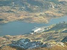
|
| Slate Dressing Mill | Ffestiniog | 2 January 1996 | SH7134546598 53°00′04″N 3°55′07″W / 53.00121451878°N 3.9186148881515°W |
Slate mill | On the main Maenofferen level, a working underground quarry, high above Llechwedd. | 16888 |
|
| Powered Incline Drumhouse including chimney | Ffestiniog | 2 January 1996 | SH7146346617 53°00′05″N 3°55′01″W / 53.001413609068°N 3.9168651434417°W |
Drumhouse | At the end of a short rock tunnel linking the main Maenofferen level with the underground incline 100m E of the slab mill. | 16892 |
|
| Arched wall to forecourt of Vaynol Old Hall | Pentir | 22 September 1997 | SH5382569556 53°12′11″N 4°11′24″W / 53.202928767513°N 4.1899500049488°W |
Wall | Located at the W side of the forecourt between Vaynol Old Hall and the Terraced Garden, and adjoining the Chapel of St Mary. | 18927 |
|
| Plas Glyn-y-Weddw | Llanbedrog | 20 January 1998 | SH3289831428 52°51′16″N 4°29′00″W / 52.854336937916°N 4.4831992464192°W |
Hall | The house is set in wooded grounds about 150m S of Llanbedrog church, and facing E to Cardigan Bay and Snowdonia over a front lawn. | 19237 | 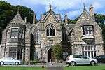
|
| Gatehouse at Cefnamwlch | Tudweiliog | 3 February 1998 | SH2339035308 52°53′10″N 4°37′35″W / 52.886135599851°N 4.6263571256261°W |
Gatehouse | Situated at the end and to the left of the main approach drive to Cefnamwlch, approximately 10m N of the NW corner of the main house. | 19428 |
|
| War Memorial | Garreg, Llanfrothen | 14 May 1998 | SH6123041728 52°57′18″N 4°04′02″W / 52.954935080828°N 4.0671507682647°W |
War Memorial | Prominently sited at the cross-roads in the centre of the village; on a raised platform with semi-circular rubble enclosing walls and iron gates and railings to the road side, terminating in cylindrical rubble piers. | 19792 | 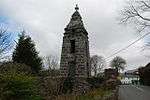
|
| The Orangery at Plas Brondanw Gardens | Llanfrothen | 14 May 1998 | SH6158142252 52°57′35″N 4°03′44″W / 52.959733254649°N 4.0621536095195°W |
Orangery | Prominently-sited on the western boundary of the garden. | 19816 | 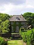
|
| Carmel Chapel | Aberdaron | 19 November 1997 | SH1625628402 52°49′18″N 4°43′42″W / 52.821728486612°N 4.7283646460476°W |
Chapel | Situated some 600m SSW of Carreg at T-junction with road from Aberdaron. | 20009 |
|
| Frondeg | Aberdaron | 26 June 1998 | SH2399429173 52°49′52″N 4°36′51″W / 52.831242089706°N 4.6140751484735°W |
Situated on common land NW of Rhiw church, some 300m N of Gwern-saer, above Bryn-y-ffynnon. | 20021 |
| |
| Bron-y-foel-isaf | Dyffryn Ardudwy | 20 August 1998 | SH6028724587 52°48′03″N 4°04′26″W / 52.800705057414°N 4.0738153518975°W |
House | In a remote position about 2 km NE of Coed Ystumgwern, reached by track on S side of minor road. | 20278 |
|
| Stable Courtyard at Glynllifon | Llandwrog | 29 April 1952 | SH4556255359 53°04′23″N 4°18′24″W / 53.073075207794°N 4.306709167996°W |
Situated to the west of the house. | 20447 |
| |
| Magazine at Fort Williamsburg | Llandwrog | 29 May 1968 | SH4599255102 53°04′15″N 4°18′01″W / 53.070891345178°N 4.3001732619122°W |
Situated immediately beside the Tower near the north-west corner of Fort Williamsburg, approximately 0.5km south-east of the house. Reached via a tunnel passage from the Parade Ground. | 20465 |
| |
| Tunnel Passage at Fort Williamsburg | Llandwrog | 29 May 1968 | SH4601855099 53°04′15″N 4°17′59″W / 53.070871913217°N 4.2997840925192°W |
On the northern side of the Fort linking the former Parade Ground and the Tower and beyond to the outer bastions. Fort Williamsburg is approximately 0.5km south-east of the house. | 20466 |
| |
| Outer Defensive Wall to Fort Williamsburg | Llandwrog | 29 May 1968 | SH4607155020 53°04′13″N 4°17′56″W / 53.070177663701°N 4.298955902004°W |
Wall | Forming a perimeter to the fort which is approximately 0.5km south-east of the house and reached by the south drive. | 20467 |
|
| Gatehouse at Fort Williamsburg | Llandwrog | 29 May 1968 | SH4604455112 53°04′16″N 4°17′58″W / 53.07099618854°N 4.2994025830254°W |
Gatehouse | Built into the bank on the north side of the fort accessed from the main north entrance via a footbridge across the ditch; faces into the former parade ground. Fort Williamsburg is approximately 0.5km south-east of the house. | 20468 |
|
| Armoury at Fort Williamsburg including attached screen walls | Llandwrog | 29 May 1968 | SH4606755061 53°04′14″N 4°17′57″W / 53.070544761648°N 4.2990351763852°W |
Armoury | Facing into the former parade ground and backing onto the Barracks at the south-east corner of Fort Williamsburg which is situated approximately 0.5km south-east of the house. | 20469 |
|
| Barracks at Fort Williamsburg | Llandwrog | 29 May 1968 | SH4608055054 53°04′14″N 4°17′56″W / 53.070485644091°N 4.2988379611125°W |
Barracks | At the south-east corner of Fort Williamsburg which is situated approximately 0.5km south-east of the house | 20470 |
|
| Grand Lodge including Archway at main entrance to Glynllifon | Llandwrog | 29 April 1952 | SH4522655370 53°04′23″N 4°18′42″W / 53.073076516577°N 4.3117253806272°W |
Lodge/Gateway | At the main entrance to Glynllifon, set back from the A499 and set into the impressive boundary wall that suurounds this park. | 20478 | 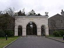
|
| Cwm Dyli Power Station | Beddgelert | 25 November 1998 | SH6532053972 53°03′58″N 4°00′41″W / 53.065974950765°N 4.0114195143756°W |
Power Station | Located towards the northern boundary of the community in an isolated site on the E side of the Afon Cynnyd, at the end of the Glaslyn valley; accessed via a long track continuing on from the old valley road. | 20926 | 
|
| Ynys Pandy Slate Mill | Dolbenmaen | 30 March 1999 | SH5498943363 52°58′05″N 4°09′39″W / 52.967967572228°N 4.160714795911°W |
Slate Mill | The mill stands on a bluff overlooking the S bank of the Afon Henwy, in the Cwmystradllyn. | 21538 | 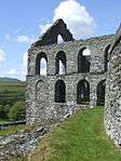
|
| Clenennau | Dolbenmaen | 30 March 1999 | SH5320442455 52°57′34″N 4°11′13″W / 52.959324502773°N 4.1868611641097°W |
Farmhouse | This important farm stands on the NE side of the road from Tremadoc to Golan and Dolbenmaen. | 21541 |
|
| Gorllwynuchaf | Dolbenmaen | 30 March 1999 | SH5762942681 52°57′45″N 4°07′16″W / 52.962550235994°N 4.1211339558209°W |
House | The house stands alone on the moorland of Mynydd Gorllwyn, and is reached by a track approximately 1500m long from the Prenteg to Cwmystradllyn minor road. | 21550 |
|
| Broom Hall | Llanystumdwy | 19 January 1952 | SH4121037215 52°54′32″N 4°21′46″W / 52.908836210652°N 4.3626945823754°W |
Hall | Broom Hall lies in its own parkland, E of Pwllheli, and on the N side of the Criccieth to Pwllheli Road. | 21586 | .jpg)
|
| Grave of David Lloyd George | Llanystumdwy | 31 March 1999 | SH4755938572 52°55′22″N 4°16′08″W / 52.922868377523°N 4.2690033095619°W |
Grave | The grave is on the N side of the road leading E from Pont Llanystumdwy, and on the wooded high bank of the Afon Dwyfor. | 21601 | 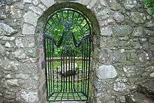
|
| Capel Methodistiaid Calfinaidd | Pistyll | 18 May 1999 | SH3578143172 52°57′39″N 4°26′47″W / 52.960700359274°N 4.446363279072°W |
Chapel | The (Calvinistic Methodist) chapel stands E of the centre of the village, with its axis parallel to the main road. | 21726 | 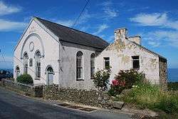
|
| Church of St Padarn | Llanberis | 28 May 1999 | SH5787259974 53°07′05″N 4°07′31″W / 53.117956380082°N 4.1251481460209°W |
Church | Located in a prominent position on rising ground behind the Dolbadarn Hotel on the south side of Stryd Fawr (High Street); the churchyard is of irregular shape and is approached from the north through iron gates in a rubblestone wall. | 21833 | .jpg)
|
| Capel Coch | Llanberis | 28 May 1999 | SH5765660030 53°07′06″N 4°07′42″W / 53.118401675215°N 4.1283980618993°W |
Chapel | Situated on very slightly rising ground on the south side of Ffordd Capel-Coch, the chapel occupies a prominent position in the street; low rubblestone wall to street continues to east to enclose forecourt with iron gates to north-east corner. | 21853 | 
|
| Glan Gwna Hall | Waunfawr | 21 July 1999 | SH5017262052 53°08′04″N 4°14′28″W / 53.134508624844°N 4.2410797929169°W |
Situated to the north of Ffordd Waenfawr in its own landscaped grounds, most of which are now occupied by the chalets and other structures associated with Glan Gwna Holiday Park. | 22055 |
| |
| Church of St Twrog | Llandwrog | 30 September 1999 | SH4512156077 53°04′46″N 4°18′49″W / 53.079396060977°N 4.3136318822023°W |
Church | Situated in the centre of Llandwrog village in raised roughly circular-shaped churchyard. | 22417 | 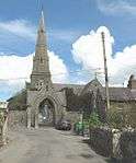
|
| Lych-gate and churchyard wall at the Church of St Twrog | Llandwrog | 30 September 1999 | SH4509056071 53°04′46″N 4°18′51″W / 53.079333157381°N 4.3140913741441°W |
The lych-gate stands on the south-east side of St Twrog's raised and roughly circular-shaped churchyard, which is surrounded and retained by the churchyard wall. | 22418 |
| |
| Bryn Hall | Mawddwy | 11 April 1999 | SH9077819391 52°45′40″N 3°37′12″W / 52.761064858565°N 3.6200304312732°W |
House | The house stands in its own grounds below the main road through the Dyfi valley, approximately 520m N of Llanymawddwy. | 22624 |
|
| Pont ar Dyfi (partly in Machynlleth Community) | Corris | 19 December 1951 | SH7441701921 52°36′02″N 3°51′20″W / 52.600536328154°N 3.8556902090969°W |
Bridge | Spanning the River Dovey to N of Machynlleth, Powys. | 22723 | 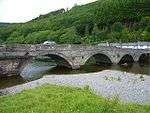
|
| Plas Aberllefenni | Corris | 12 June 1999 | SH7710909941 52°40′24″N 3°49′08″W / 52.673214189992°N 3.8189521515048°W |
House | The house stands at the N end of Aberllefenni, in a loop of the road running to the E to Aberangell. | 22727 |
|
| Ty Mawr | Nantlle, Llanllyfni | 29 May 1968 | SH5086053344 53°03′23″N 4°13′36″W / 53.056485153746°N 4.2267597529879°W |
Located at the western end of Nantlle near the eastern entrance to the Dorothea Slate Quarry. | 22899 | 
| |
| Engine House, Boilerhouse, Bunker and remains of chimney to south | Llanllyfni | 12 October 1992 | SH4972753124 53°03′15″N 4°14′37″W / 53.054190978749°N 4.2435483130817°W |
Engine House | On a ridge of rock which divides the main Dorothea Quarry from the South Dorothea Quarry; located by the side of the road access to the quarry. Pump house. | 22901 | 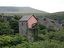
|
| Bridge at the mouth of the Afon Ogwen (partly in Llandygai community) | Llanllechid | 3 September 2000 | SH6107072139 53°13′41″N 4°04′58″W / 53.228078571831°N 4.0826861730818°W |
Bridge | Situated at the mouth of the Afon Ogwen where it flows into the sea approximately 120m east of Capel Ogwen; carries the drive from Port Lodge to Capel Ogwen; remains of small stone-paved wharf on eastern bank. | 22931 | 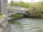
|
| Farmbuildings at Ty'n-yr-hendre | Llanllechid | 3 September 2000 | SH6224971130 53°13′10″N 4°03′53″W / 53.219322500394°N 4.0646007331695°W |
Farm buildings | Situated around 4 sides of an excellently preserved cobbled yard below and to the north-west of the former farmhouse at Ty'n-yr-hendre. | 22971 |
|
| Shelter Shed/Pigsties at Ty'n-yr-hendre | Llanllechid | 3 September 2000 | SH6226671138 53°13′10″N 4°03′52″W / 53.219398780766°N 4.0643497571685°W |
Pigsties | Located in the middle of the cobbled farmyard at Ty'n-yr-hendre. | 22972 |
|
| Wyatt Memorial at the Church of St Tegai | Llandygai | 24 May 2000 | SH6008470977 53°13′03″N 4°05′49″W / 53.217381207802°N 4.0969358299281°W |
Memorial | Located directly to the south of the chancel of the Church of St Tegai. | 23366 | .jpg)
|
| New Dock (quay) | Llandygai | 24 May 2000 | SH5912572880 53°14′03″N 4°06′44″W / 53.234221327006°N 4.1121292052764°W |
Quay | Built on Bangor flats at the mouth of the Afon Cegain which flows into the Menai Strait at this point. | 23439 |
|
| Bridge at the mouth of the Afon Ogwen (partly in Llanllechid community) | Llandygai | 3 September 2000 | SH6105672141 53°13′41″N 4°04′58″W / 53.228092867558°N 4.0828966188399°W |
Bridge | Situated at the mouth of the Afon Ogwen where it flows into the sea approximately 120m east of Capel Ogwen; carries the drive from Port Lodge to Capel Ogwen; remains of small stone-paved wharf on eastern bank. | 23456 |
|
| Pale Hall | Llandderfel | 31 January 2001 | SH9826236078 52°54′45″N 3°30′52″W / 52.912482708743°N 3.5143757827918°W |
Hall | Located on the eastern side of the River Dee approximately 1.2km S of Llandderfel village; accessed via a drive leading from the road. | 24595 | 
|
| Parish Church of St Deiniol | Llanuwchllyn | 31 January 2001 | SH8737130282 52°51′30″N 3°40′27″W / 52.858226215326°N 3.6742533934685°W |
Church | Within its own raised and walled churchyard in the centre of the village. | 24688 | 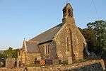
|
| Neuadd Wen | Llanuwchllyn | 31 January 2001 | SH8785330052 52°51′23″N 3°40′01″W / 52.85626035622°N 3.6670186510704°W |
Set within its own grounds within the village, not far from the station. | 24696 |
| |
| Gwyndy | Llanuwchllyn | 31 January 2001 | SH8785630063 52°51′23″N 3°40′01″W / 52.856359823483°N 3.6669779053165°W |
House | Set within its own grounds within the village, not far from the station. | 24697 |
|
| Coleg Harlech including Terrace Revettment Walls to the W | Harlech | 21 June 2001 | SH5782830805 52°51′21″N 4°06′47″W / 52.855919285528°N 4.1129728593188°W |
College | Set back slightly from the road within its own grounds with commanding views across the Morfa. | 25511 | 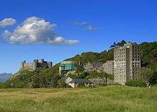
|
| Rosedale, Including Forecourt Walls & Railings | Bala | 13 December 2001 | SH9269336167 52°54′44″N 3°35′50″W / 52.912197062638°N 3.5971864706015°W |
House | Set back behind a walled and railed forecourt; belonging to terrace of 8. | 25968 |
|
| Derlwyn | Bala | 13 December 2001 | SH9268836162 52°54′44″N 3°35′50″W / 52.912151133208°N 3.5972591393498°W |
House | Set back behind a walled and railed forecourt; belonging to terrace of 8. | 25969 |
|
| Islwyn | Bala | 13 December 2001 | SH9268536157 52°54′44″N 3°35′50″W / 52.912105603955°N 3.5973020791176°W |
House | Set back behind a walled and railed forecourt; belonging to terrace of 8. | 25970 |
|
| Ronville | Bala | 13 December 2001 | SH9268036154 52°54′43″N 3°35′51″W / 52.91207764603°N 3.5973754090274°W |
House | Set back behind a walled and railed forecourt; belonging to terrace of 8. | 25971 |
|
| Dolydd | Bala | 13 December 2001 | SH9267536149 52°54′43″N 3°35′51″W / 52.912031716487°N 3.597448077376°W |
House | Set back behind a walled and railed forecourt; belonging to terrace of 8. | 25972 |
|
| Fedw Arian | Bala | 13 December 2001 | SH9267136144 52°54′43″N 3°35′51″W / 52.911985987034°N 3.5975058811999°W |
House | Set back behind a walled and railed forecourt; belonging to terrace of 8. | 25973 |
|
| Isfryn | Bala | 13 December 2001 | SH9266736140 52°54′43″N 3°35′51″W / 52.91194924334°N 3.5975640156583°W |
House | Set back behind a walled and railed forecourt; belonging to terrace of 8. | 25974 |
|
| Awelfryn | Bala | 13 December 2001 | SH9266136136 52°54′43″N 3°35′52″W / 52.911912099319°N 3.5976518787082°W |
House | Set back behind a walled and railed forecourt; belonging to terrace of 8. | 25975 |
|
| Caernarfon Royal Town Council Offices, including 10 Bangor Street | Caernarfon | 5 March 2002 | SH4801862850 53°08′28″N 4°16′25″W / 53.141064808846°N 4.2736287572181°W |
Offices | On the corner of Pavilion Hill and Bangor Street. | 26598 |
|
| Felin Sarn | Llanddeiniolen | 21 May 2003 | SH5718763138 53°08′46″N 4°08′12″W / 53.146194198332°N 4.1367860067527°W |
Mill | On S side of minor road through village, about 1km E of junction with B 4547. | 80871 |
|
| Gateway to the Church of Saint Mary | Tremadog, Porthmadog | 4 January 1974 | SH5628240037 52°56′18″N 4°08′24″W / 52.938439258428°N 4.1400002198576°W |
Gateway | Forming the W entrance to the churchyard, from Church Street. | 83132 | 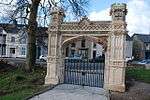
|
| Llanfendigaid | Llangelynin | 6 July 2005 | SH5675804994 52°37′26″N 4°07′03″W / 52.623765480167°N 4.1175783970048°W |
House | In its own grounds on the W side of a minor road approximately 1.2km SW of Rhoslefain hamlet. | 84474 |
|
| Multi-purpose farm range at Bryndinas | Tywyn | 24 June 2005 | SN6350198543 52°34′03″N 4°00′55″W / 52.567549647357°N 4.0153691350333°W |
Farm buildings | To the S of the house and the central of 3 parallel farm ranges. | 84545 |
|
| The Cob (partly in Penrhyndeudraeth) | Porthmadog | 22 February 1991 | SH5746738294 52°55′23″N 4°07′18″W / 52.923098443458°N 4.1216143013974°W |
Causeway | Embankment across the S end of Traeth Mawr, on the E side of Porthmadog harbour and town. | 85406 |
|
| Taltreuddyn-Fawr | Dyffryn Ardudwy | 13 October 2006 | SH5827525677 52°48′36″N 4°06′15″W / 52.809970923762°N 4.10411054634°W |
House | On the north side of a lane which runs west from the A496, some 2.5km north of Dyffryn Ardudwy. | 87510 |
|
| Nant Pasgan-Mawr | Talsarnau | 20 October 2008 | SH6541936556 52°54′34″N 4°00′10″W / 52.909540749099°N 4.002689592403°W |
House | In an isolated upland location on the NW side of the little valley of the Nant Ddu, beyond the road-head of a lane which trends ESE from Llyn Tecwyn Isa, and follows the valley beyond Caerwych. The principal front faces across the Nant Ddu valley. | 87558 | |
Notes
- ↑ Sometimes known as OSGB36, the grid reference is based on the British national grid reference system used by the Ordnance Survey.
- ↑ The "HB Number" is a unique number assigned to each listed building by Cadw.
See also
References
- ↑ "Buildings & Conservation Areas". Cadw. Retrieved 18 June 2013.
- ↑ "Planning (Listed Buildings and Conservation Areas) Act 1990". The National Archives. Retrieved 18 June 2013.
External links
![]() Media related to Grade II* listed buildings in Gwynedd at Wikimedia Commons
Media related to Grade II* listed buildings in Gwynedd at Wikimedia Commons
This article is issued from Wikipedia - version of the 11/29/2016. The text is available under the Creative Commons Attribution/Share Alike but additional terms may apply for the media files.