Grade II* listed buildings in Bridgend County Borough

Bridgend County Borough shown within Wales
In the United Kingdom, the term listed building refers to a building or other structure officially designated as being of special architectural, historical, or cultural significance; Grade II* structures are those considered to be "particularly important buildings of more than special interest".[1] Listing was begun by a provision in the Town and Country Planning Act 1947. Once listed, strict limitations are imposed on the modifications allowed to a building's structure or fittings. In Wales, the authority for listing under the Planning (Listed Buildings and Conservation Areas) Act 1990[2] rests with Cadw.
Buildings
| Name | Location | Date Listed | Grid Ref.[note 1] Geo-coordinates |
Function | Notes | HB No[note 2] | Image |
|---|---|---|---|---|---|---|---|
| Nottage Court | Nottage | 5 January 1951 | SS8204078165 51°29′24″N 3°42′02″W / 51.490109322661°N 3.700434078397°W |
House | On the E edge of the hamlet of Nottage, on rising ground above the valley of Dewiscumbe, set in large walled grounds reached by a drive. | 11213 | 
|
| Tythegston Court | Tythegston | 6 June 1953 | SS8568378932 51°29′52″N 3°38′54″W / 51.497752690081°N 3.6482345315559°W |
House | On N side of A4106 opposite minor road into Tythegston village, and reached by short private road on NW side. | 11216 |
|
| Glan Rhyd Railway Viaduct | Newcastle Higher | 26 July 1963 | SS8989182786 51°32′00″N 3°35′20″W / 51.53322930492°N 3.5888452825147°W |
Viaduct | Spanning River Ogmore on a minor road E of A4063 and almost directly beneath viaduct of M4. | 11228 | 
|
| Candleston Castle | Merthyr Mawr | 26 July 1963 | SS8713677252 51°28′59″N 3°37′36″W / 51.482945684897°N 3.626774225602°W |
Castle | About 1.2km WSW of Merthyr Mawr church, on the E (inland) side of sand dunes at Merthyr Mawr Warren, and at the end of a minor road W of Merthyr Mawr village. | 11230 | 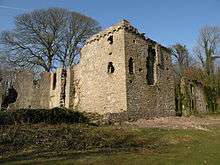
|
| New Inn Bridge | Merthyr Mawr | 26 July 1963 | SS8910078391 51°29′37″N 3°35′56″W / 51.493572262371°N 3.5988603709341°W |
Bridge | Road bridge over Ogmore river approximately 1.2km NE of Merthyr Mawr church. | 11235 | 
|
| New Bridge, Merthyr Mawr | Merthyr Mawr | 26 July 1963 | SS8915777965 51°29′23″N 3°35′52″W / 51.489754590948°N 3.5979057405119°W |
Bridge | Crossing the Ogmore river approximately 1km NE of Merthyr Mawr church. | 11236 | 
|
| St Teilo's Church | Merthyr Mawr | 26 July 1963 | SS8828477520 51°29′08″N 3°36′37″W / 51.485582823578°N 3.6103335748504°W |
Church | On NW side of settlement and N side of minor road between village and Merthyr Mawr Warren. | 11242 | 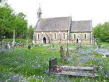
|
| St Cynwyd's Church | Llangynwyd Middle | 26 July 1963 | SS8573288830 51°35′12″N 3°39′03″W / 51.586722427613°N 3.6507458423777°W |
Church | The church lies at the centre of the village of Llangynwyd, surrounded by a D-shaped stone walled graveyard. | 11243 | 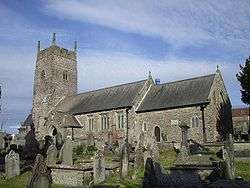
|
| Ty Mawr aka The Great House | Laleston | 26 July 1963 | SS8747679783 51°30′21″N 3°37′22″W / 51.505761813242°N 3.6226877399594°W |
House | On the main village thoroughfare a short distance SW of the Church of St David. | 11244 |
|
| Church of St Mary Magdalen | Cynffig | 26 July 1963 | SS8066281947 51°31′26″N 3°43′18″W / 51.523809842984°N 3.7215535494509°W |
Church | The church stands in a raised curvilinear churchyard on a high prominence above the former site of Kenfig, by the junction of the side road into Maudlam village. | 11248 | 
|
| Ty Mawr, Coity Higher | Coity Higher | 26 July 1963 | SS9290481756 51°31′28″N 3°32′42″W / 51.524552265538°N 3.5451104258651°W |
House | Approximately 0.5km NE of Coity church on E side of minor road from Coity to Cefn Hirgoed, and S side of junction with minor road to Pencoed. | 11253 | 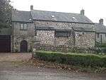
|
| Llwydarth farmhouse | Maesteg | 27 October 1963 | SS8586590156 51°35′55″N 3°38′57″W / 51.598666964387°N 3.649258684356°W |
Farmhouse | The farmhouse is set on a steep hill, with access by farm track directly off the A4063 Maesteg to Bridgend Road. | 11256 |
|
| Maesteg Sports Centre, The Cornstores | Maesteg | 13 October 1966 | SS8485791515 51°36′38″N 3°39′51″W / 51.61067539639°N 3.6642520654832°W |
Sports Centre | The Sports Centre is at the end of Albert Terrace, leading off Neath Road. | 11257 | 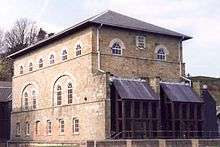
|
| Old Bridge, Bridgend | Bridgend | 29 September 1986 | SS9041679837 51°30′25″N 3°34′49″W / 51.506826064504°N 3.5803614217086°W |
Bridge | 11303 | 
| |
| St John's Hospice | Bridgend | 21 August 1952 | SS9029579915 51°30′27″N 3°34′56″W / 51.50750360558°N 3.5821284507489°W |
Hospice | Set into slope, half way up the hill; small rubble walled gardens flanking entrance. | 11311 | 
|
| St Illtyd's Church, Bridgend | Bridgend | 29 September 1986 | SS9026280039 51°30′31″N 3°34′58″W / 51.508611697815°N 3.5826423785089°W |
Church | To S of the castle, high above the town. | 11312 | 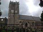
|
| Newcastle Castle, Bridgend | Bridgend | 29 September 1986 | SS9022480078 51°30′32″N 3°35′00″W / 51.508954834209°N 3.5832018600115°W |
Castle | On an elevated site to N of St Illtyd's Parish Church. | 11313 | 
|
| Newcastle House, Bridgend | Bridgend | 29 September 1986 | SS9011879987 51°30′29″N 3°35′05″W / 51.508116283235°N 3.5847002400598°W |
House | Set back and above the road, to W of the castle and Parish church. | 11318 | 
|
| Merthyr Mawr House | Merthyr Mawr | 5 April 1973 | SS8888577942 51°29′22″N 3°36′07″W / 51.489494377525°N 3.6018145558333°W |
Country House | About 0.75km NE of parish church and reached by private drives on its W and NE sides. | 11323 | .jpg)
|
| Maendy Farm, St Bride's Minor | St Bride's Minor | 23 September 1974 | SS9084284153 51°32′45″N 3°34′32″W / 51.545700920673°N 3.5755646381495°W |
Farmhouse | On sloping ground above Nant Bryncethin, W of Bryncethin village with dismantled railway close to rear. | 11327 | 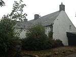
|
| Iron bridge over River Llynfi | Maesteg | 8 September 1979 | SS8511791531 51°36′39″N 3°39′38″W / 51.610872416188°N 3.660504194683°W |
Bridge | Located at the bottom end of Treharne Row, off Castle Street, and below the rugby ground. | 11331 | 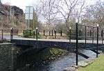
|
| The Hall Farm, Cynffig | Cynffig | 22 June 1988 | SS8205681628 51°31′16″N 3°42′05″W / 51.521236288986°N 3.7013629321866°W |
Farmhouse | The former farmhouse lies in the midst of suburban development at the end of a driveway opening between Nos 33 and 35 Hall Drive. | 11349 | 
|
| Bethania Capel y Bedyddwyr Neillduol | Maesteg | 14 July 1997 | SS8579690862 51°36′18″N 3°39′02″W / 51.604998166098°N 3.6504845614411°W |
Chapel | Located prominently on an elevated site behind a railed forecourt, and facing down Ewenny Road. | 18493 | 
|
| Salem Welsh Baptist Chapel | Nantyffyllon, Maesteg | 14 July 1997 | SS8505192746 51°37′18″N 3°39′43″W / 51.621778710956°N 3.6618558455805°W |
Chapel | Located in a row of terraced housing, and set behind a narrow front railed area. | 18495 | 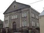
|
| Maesteg Council Offices, with flanking walls and piers | Maesteg | 14 July 1997 | SS8522591309 51°36′32″N 3°39′32″W / 51.608899261201°N 3.6588724442134°W |
Offices | Located behind the town hall on the S side of Talbot Street. | 18499 | 
|
| Church of St Tyfodwg, Llandyfodwg – Glynogwr | Ogmore Valley | 28 July 1997 | SS9564087235 51°34′28″N 3°30′26″W / 51.574312173108°N 3.5073149602454°W |
Church | The church stands in its churchyard the centre of the hamlet of Glynogwr, approximately halfway between Blackmill and Gilfach Goch. | 18604 | 
|
| Church of St Cein | Garw Valley | 10 August 1990 | SS9247887941 51°34′48″N 3°33′11″W / 51.580062349423°N 3.5531412042752°W |
Church | Situated on the hilltop approx 2 km NE Llangeinor, reached from the road that links Garw and Ogmore Valleys, centre of a small rural settlement. | 18635 | 
|
| Cefn Cribwr ironworks, the furnace and charging house | Cefn Cribwr | 10 February 1997 | SS8510583447 51°32′18″N 3°39′29″W / 51.538214536267°N 3.6580307608004°W |
Ironworks | The ironworks is located near the bottom of the Nant Iorwerth Coch, on the S side of the brook. The furnace stands at the hub of the group of buildings. | 18955 | 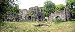
|
| Cast house at Cefn Cribwr Ironworks | Cefn Cribwr | 10 February 1997 | SS8510283467 51°32′18″N 3°39′29″W / 51.53839367681°N 3.6580805316631°W |
Ironworks | The ironworks lies at the bottom of the Nant Iorwerth Coch. The casting house adjoins the furnace on the N side. | 18957 |
|
| Churchyard Cross in Coychurch Churchyard | Coychurch Lower | 15 October 1997 | SS9395679677 51°30′22″N 3°31′46″W / 51.50606466589°N 3.52932630362°W |
Cross | Situated in Coychurch churchyard very close to the S door of the Church of St Crallo. | 18965 | 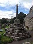
|
| Pyle Calvinistic Methodist Chapel, Capel y Pil, and schoolroom, with forecourt railings | Cynffig | 1 February 1998 | SS8236681605 51°31′16″N 3°41′49″W / 51.52109435777°N 3.6968892277887°W |
Chapel | Ffordd y Eglwys leads from Pyle to North Cornelly. The chapel is set gable end to the road W of the former railway line, with the schoolroom adjoining on the S. | 19171 | 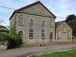
|
| Glan Rhyd Railway Viaduct (partly in Newcastle Higher community) | St Bride's Minor | 26 July 1963 | SS8989782793 51°32′00″N 3°35′20″W / 51.533293392951°N 3.5887610070721°W |
Viaduct | Spanning River Ogmore on a minor road E of A4063 and almost directly beneath viaduct of M4. | 20179 | 
|
| Former Blast Engine Houses at Tondu Ironworks | Ynysawdre | 11 September 1998 | SS8914584429 51°32′52″N 3°36′00″W / 51.547850113526°N 3.6001139028592°W |
Engine House | At the foot of the hillside into which the Ironworks was built, West of Tondu station and Maesteg Road and at the edge of the now cleared former coal and rail works and yards. | 20763 | 
|
| Calcining Kilns and attached abutment at Tondu Ironworks | Ynysawdre | 11 September 1998 | SS8914484463 51°32′53″N 3°36′01″W / 51.54815550409°N 3.6001390425973°W |
Kiln | Set in the hillside between the company housing of Derllwyn Road and Park Terrace above and the levelled area below where the Engine House stands, just above the old furnace bank and opposite the Lift Tower. | 20816 | 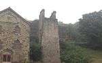
|
| Lift Tower at Tondu Ironworks | Ynysawdre | 11 September 1998 | SS8914784450 51°32′53″N 3°36′00″W / 51.548039252381°N 3.600091695129°W |
Ironworks | Set in the hillside between the company housing of Derllwyn Road and Park Terrace above and the levelled area below where the Engine House stands, against the old furnace bank and opposite the Calcining Kilns. | 20817 |
|
| Coychurch Cemetery Chapel of Remembrance | Coychurch Lower | 31 October 2001 | SS9315680215 51°30′39″N 3°32′28″W / 51.510749327538°N 3.5410117756412°W |
Chapel | Within the cemetery grounds between the entrance and the main chapel complex and joined to the latter by a conifer lined walkway. | 25840 | 
|
| Coychurch Cemetery Capel Crallo and Capel Coity | Coychurch Lower | 31 October 2001 | SS9323680206 51°30′38″N 3°32′23″W / 51.510683585563°N 3.5398567014203°W |
Chapel | The main Capel Crallo fronts a lake with fountains and is joined to the smaller Capel Coity by a cloister walk and garden. | 25841 | 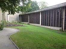 |
Notes
- ↑ Sometimes known as OSGB36, the grid reference is based on the British national grid reference system used by the Ordnance Survey.
- ↑ The "HB Number" is a unique number assigned to each listed building by Cadw.
See also
References
- ↑ "Buildings & Conservation Areas". Cadw. Retrieved 18 June 2013.
- ↑ "Planning (Listed Buildings and Conservation Areas) Act 1990". The National Archives. Retrieved 18 June 2013.
External links
![]() Media related to Grade II* listed buildings in Bridgend County Borough at Wikimedia Commons
Media related to Grade II* listed buildings in Bridgend County Borough at Wikimedia Commons
| Communities | | |
|---|---|---|
| Towns and villages |
| |
| Castles | ||
| Rivers | ||
| Topics | ||
This article is issued from Wikipedia - version of the 8/6/2016. The text is available under the Creative Commons Attribution/Share Alike but additional terms may apply for the media files.