| Name |
Location |
Date Listed |
Grid Ref.[note 1]
Geo-coordinates |
Function |
Notes |
HB No[note 2] |
Image |
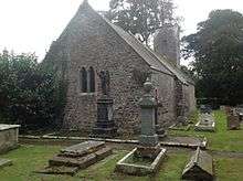
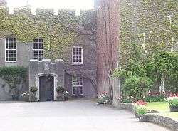
| Ewenny Priory Church |
Ewenny |
000000001963-07-26-000026 July 1963 |
SS9125777813
51°29′20″N 3°34′03″W / 51.488796966353°N 3.5676241603519°W / 51.488796966353; -3.5676241603519 (Ewenny Priory Church) |
Church |
The E part of the surviving Priory complex, on the S bank of the Ewenny River, NE of Ewenny village and due N of Corntown, bordered by Ewenny Priory (house) gardens to S and churchyard N. |
11250 |
 Upload another image
See more images
|
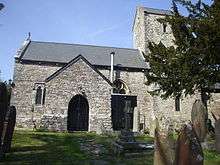
| Church of St Michael |
Ewenny |
000000001963-07-26-000026 July 1963 |
SS9124277808
51°29′19″N 3°34′04″W / 51.488749135387°N 3.5678385766295°W / 51.488749135387; -3.5678385766295 (Church of St Michael) |
Church |
The W part of the surviving Priory church, on the E side of the Priory complex, on S bank of Ewenny River, NE of Ewenny Village and N of Corntown. |
11251 |
 Upload another image
|
| Llanmihangel Place |
Llandow |
000000001952-12-16-000016 December 1952 |
SS9811571947
51°26′14″N 3°28′02″W / 51.437349898281°N 3.467191921422°W / 51.437349898281; -3.467191921422 (Llanmihangel Place) |
Manor House |
|
13136 |
.jpg) Upload another image
See more images
|
| Llansannor Court |
Llansannor |
000000001952-12-16-000016 December 1952 |
SS9935077460
51°29′14″N 3°27′04″W / 51.487125383977°N 3.4510016067522°W / 51.487125383977; -3.4510016067522 (Llansannor Court) |
House |
In the centre of Llansannor village beside the Church of St. Senwyr. |
13137 |
 Upload another image
|
| Nash Manor |
Llandow |
000000001952-12-16-000016 December 1952 |
SS9623872932
51°26′45″N 3°29′40″W / 51.445862204951°N 3.4944751685214°W / 51.445862204951; -3.4944751685214 (Nash Manor) |
Manor House |
|
13138 |

|
| Church of St John the Baptist, Llanblethian |
Llanblethian |
000000001963-02-22-000022 February 1963 |
SS9850174028
51°27′22″N 3°27′44″W / 51.456124604077°N 3.4622381167762°W / 51.456124604077; -3.4622381167762 (Church of St John the Baptist, Llanblethian) |
Church |
To N and above village in large churchyard. |
13144 |
 Upload another image
See more images
|
| Church of St Michael and All Angels, Colwinston |
Colwinston |
000000001963-02-22-000022 February 1963 |
SS9396475396
51°28′03″N 3°31′41″W / 51.467587399611°N 3.5279239754441°W / 51.467587399611; -3.5279239754441 (Church of St Michael and All Angels, Colwinston) |
Church |
At the west end of Colwinston village. |
13161 |
 Upload another image
|
| Church of St Senwyr |
Llansannor |
000000001963-02-22-000022 February 1963 |
SS9936777509
51°29′15″N 3°27′03″W / 51.487568855936°N 3.4507708326178°W / 51.487568855936; -3.4507708326178 (Church of St Senwyr) |
Church |
In the centre of Llansannor village about 4 km north of Cowbridge. |
13162 |
 Upload another image
|
| St Tathan's Church |
St Athan |
000000001963-02-22-000022 February 1963 |
ST0170168003
51°24′09″N 3°24′52″W / 51.402532779197°N 3.414523006149°W / 51.402532779197; -3.414523006149 (St Tathan's Church) |
Church |
In the centre of St Athan village. |
13166 |
 Upload another image
|
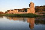
| Old Beaupre Castle |
Llanfair |
000000001963-02-22-000022 February 1963 |
ST0090672024
51°26′19″N 3°25′37″W / 51.438538076987°N 3.4270735749451°W / 51.438538076987; -3.4270735749451 (Old Beaupre Castle) |
Castle |
Located approximately 2km SW of St Hilary on the E bank of the river Thaw, set on a platformed site, with pedestrian access from St Hilary to St Mary Church road to NW, opposite Howe Mill Farm. |
13171 |
.JPG) Upload another image
See more images
|
| Dovecote at Cadoxton Court |
Barry |
000000001962-09-18-000018 September 1962 |
ST1276968808
51°24′42″N 3°15′20″W / 51.411582956716°N 3.2556532668365°W / 51.411582956716; -3.2556532668365 (Dovecote at Cadoxton Court) |
Dovecote |
|
13176 |
 Upload another image
|
| Church of the Holy Cross, Cowbridge |
Cowbridge |
000000001963-05-12-000012 May 1963 |
SS9939574594
51°27′41″N 3°26′58″W / 51.461372056926°N 3.4495367138654°W / 51.461372056926; -3.4495367138654 (Church of the Holy Cross, Cowbridge) |
Church |
To NE of town gate and grammar school. |
13187 |
.jpg) Upload another image
|
| St Illtyd's Church, Llantwit Major |
Llantwit Major |
000000001963-02-22-000022 February 1963 |
SS9662368719
51°24′29″N 3°29′16″W / 51.408064090262°N 3.4877065504318°W / 51.408064090262; -3.4877065504318 (St Illtyd's Church, Llantwit Major) |
Church |
In the centre of Llantwit Major, west of The Square and well below it. |
13259 |
 Upload another image
See more images
|
| Church of the Holy Trinity, St Donats |
Marcross, St Donats |
000000001963-02-22-000022 February 1963 |
SS9209469063
51°24′37″N 3°33′10″W / 51.410310737533°N 3.5529022925992°W / 51.410310737533; -3.5529022925992 (Church of the Holy Trinity, St Donats) |
Church |
In the centre of Marcross village. |
13303 |
 Upload another image
|
| St Donat's Castle, including entrance bridge |
St Donats |
000000001952-12-16-000016 December 1952 |
SS9343268108
51°24′07″N 3°32′00″W / 51.401980375972°N 3.5333843092096°W / 51.401980375972; -3.5333843092096 (St Donat's Castle, including entrance bridge) |
Castle |
The castle stands on a rocky outcrop overlooking the Bristol Channel with the terraced gardens descending to the sea on the south side. The village was originally at the gate and round the church but it was moved away in the C19. |
13325 |
 Upload another image
See more images
|
| Walls, Steps, Terraces, Pavilion, Summerhouses and Cottage attached to wall of the Hanging Gardens |
St Donats |
000000001963-02-22-000022 February 1963 |
SS9344768021
51°24′04″N 3°31′59″W / 51.40120121049°N 3.5331426008808°W / 51.40120121049; -3.5331426008808 (Walls, Steps, Terraces, Pavilion, Summerhouses and Cottage attached to wall of the Hanging Gardens) |
Terracing |
Stepping down in tiers from the main south front of St Donats Castle towards the sea. |
13326 |
|
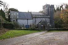
| Church of St Donat |
St Donats |
000000001963-02-22-000022 February 1963 |
SS9336468066
51°24′06″N 3°32′04″W / 51.401590059437°N 3.5343488440746°W / 51.401590059437; -3.5343488440746 (Church of St Donat) |
Church |
In the bottom of the cwm below the west side of the castle. |
13329 |
 Upload another image
|
| Medieval Cross and associated Slab in the Churchyard of the Church of St Donat |
St Donats |
000000001963-02-22-000022 February 1963 |
SS9336868052
51°24′05″N 3°32′03″W / 51.401464975637°N 3.5342871518229°W / 51.401464975637; -3.5342871518229 (Medieval Cross and associated Slab in the Churchyard of the Church of St Donat) |
|
About 10m from the south side of the church. |
13330 |
|
| St Augustine's Church |
Penarth |
000000001989-04-04-00004 April 1989 |
ST1884072040
51°26′30″N 3°10′09″W / 51.441540869179°N 3.1691225158235°W / 51.441540869179; -3.1691225158235 (St Augustine's Church) |
Church |
In walled churchyard on highest part of Penarth Head; entrance close to junction with St Augustine's Place. |
13347 |
 Upload another image
See more images
|
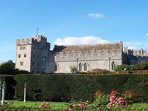
| Hensol Castle (including attached courtyard grandes to N) |
Pendoylan |
000000001993-05-02-00002 May 1993 |
ST0474078949
51°30′05″N 3°22′26″W / 51.501445277206°N 3.3737995799247°W / 51.501445277206; -3.3737995799247 (Hensol Castle (including attached courtyard grandes to N)) |
Castle |
|
13482 |
 Upload another image
See more images
|
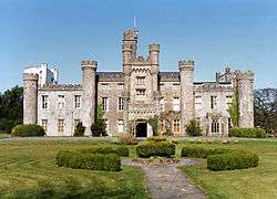
| Fonmon Castle |
Rhoose |
000000001952-02-14-000014 February 1952 |
ST0473868097
51°24′14″N 3°22′15″W / 51.403896943357°N 3.3709025378391°W / 51.403896943357; -3.3709025378391 (Fonmon Castle) |
Castle |
On the north side of the B4265 but approached via a drive from Fonmon village. |
13597 |
 Upload another image
See more images
|
| Castle Farmhouse |
St Georges-super-Ely |
000000001952-02-14-000014 February 1952 |
ST0986776785
51°28′58″N 3°17′58″W / 51.482835237284°N 3.2994030383844°W / 51.482835237284; -3.2994030383844 (Castle Farmhouse) |
Farmhouse |
In the centre of the small hamlet of St Georges, which is about 0.5 m from the church; the River Ely runs along the N side. |
13600 |
|
| St Cadoc's parish church, Llancarfan |
Llancarfan |
000000001963-01-28-000028 January 1963 |
ST0512470198
51°25′22″N 3°21′57″W / 51.422847715336°N 3.3659178991134°W / 51.422847715336; -3.3659178991134 (St Cadoc's parish church, Llancarfan) |
Church |
|
13605 |
 Upload another image
See more images
|
| Church of St Michael, Michaelston-le-Pit |
Michaelston-le-Pit |
000000001963-01-28-000028 January 1963 |
ST1518072981
51°26′58″N 3°13′19″W / 51.449462687111°N 3.2219957203399°W / 51.449462687111; -3.2219957203399 (Church of St Michael, Michaelston-le-Pit) |
Church |
In the centre of the village, on a steep rise, the churchyard sloping to S. |
13612 |
 Upload another image
|
| Church of St Donat, Welsh St Donats |
Welsh St Donats |
000000001963-01-28-000028 January 1963 |
ST0279076266
51°28′37″N 3°24′04″W / 51.476995743772°N 3.401144407066°W / 51.476995743772; -3.401144407066 (Church of St Donat, Welsh St Donats) |
Church |
In the centre of Welsh St Donats village. |
13641 |
 Upload another image
|
| Coedarhydyglyn including attached outbuildings at rear |
St Georges Super Ely |
000000001994-09-13-000013 September 1994 |
ST1043275137
51°28′05″N 3°17′27″W / 51.468110959673°N 3.2908503453194°W / 51.468110959673; -3.2908503453194 (Coedarhydyglyn including attached outbuildings at rear) |
House |
In an elevated position overlooking surrounding parkland and the Vale of Glamorgan beyond; reached by a long drive from the lane to Drope and St Georges which leads off the A48 at Tumbledown. |
14864 |
|
| W Precinct Wall at Ewenny Priory (house) |
Ewenny |
000000001998-03-03-00003 March 1998 |
SS9112177726
51°29′17″N 3°34′10″W / 51.487988780915°N 3.5695553208377°W / 51.487988780915; -3.5695553208377 (W Precinct Wall at Ewenny Priory (house)) |
Wall |
W of Ewenny Priory and just S of Ewenny River, bordering the lane and now enclosing part of Ewenny Priory (house) garden. |
19460 |
 Upload another image
See more images
|
| N Gatehouse at Ewenny Priory (house) |
Ewenny |
000000001998-03-03-00003 March 1998 |
SS9114877809
51°29′19″N 3°34′09″W / 51.488740000747°N 3.5691922216155°W / 51.488740000747; -3.5691922216155 (N Gatehouse at Ewenny Priory (house)) |
Gatehouse |
Facing Abbey Road and Ewenny River, within the Priory complex on NW side. |
19462 |
 Upload another image
See more images
|
| Romanesque gateway in former E precinct wall at Ewenny Priory (house) |
Ewenny[4] |
000000001998-03-03-00003 March 1998 |
SS9129377793
51°29′19″N 3°34′02″W / 51.48862413988°N 3.5670996953184°W / 51.48862413988; -3.5670996953184 (Romanesque gateway in former E precinct wall at Ewenny Priory (house)) |
Gateway |
Set in stretch of original medieval precinct wall on E side of Ewenny Priory (house) garden. |
19466 |
|
| N tower and attached stretch of precinct wall at Ewenny Priory (house) |
Ewenny[5] |
000000001998-03-03-00003 March 1998 |
SS9119677834
51°29′20″N 3°34′07″W / 51.488973959212°N 3.5685088695422°W / 51.488973959212; -3.5685088695422 (N tower and attached stretch of precinct wall at Ewenny Priory (house)) |
Tower |
On the N side of the Priory complex, facing Abbey Road and Ewenny River, close to the Priory churchyard and backing onto the Stable Court of Ewenny Priory (house). |
19470 |
.JPG) Upload another image
See more images
|
| S Gatehouse at Ewenny Priory (house) |
Ewenny[6] |
000000001998-03-03-00003 March 1998 |
SS9117577712
51°29′16″N 3°34′08″W / 51.487873362752°N 3.5687735652249°W / 51.487873362752; -3.5687735652249 (S Gatehouse at Ewenny Priory (house)) |
Gatehouse |
At the S boundary of Ewenny Priory garden adjoining the parkland S and the precinct wall W. |
19471 |
 Upload another image
See more images
|
| Ogmore Castle |
St Brides Major |
000000001999-03-03-00003 March 1999 |
SS8819176969
51°28′50″N 3°36′41″W / 51.480612067096°N 3.6114977626924°W / 51.480612067096; -3.6114977626924 (Ogmore Castle) |
Castle |
Located on the SE side of the River Ewenny, just before it joins the Ogmore River, in the hamlet of Ogmore to the NW of the B4524. A series of stepping stones cross the river at this point. |
21793 |
 Upload another image
See more images
|
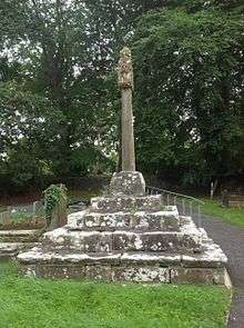
| Churchyard Cross at Church of St Canna |
Llangan |
000000002003-07-22-000022 July 2003 |
SS9575277814
51°29′23″N 3°30′10″W / 51.489654177822°N 3.5029073649504°W / 51.489654177822; -3.5029073649504 (Churchyard Cross at Church of St Canna) |
Churchyard Cross |
In the churchyard beside the main path. |
81314 |
 Upload another image
|
