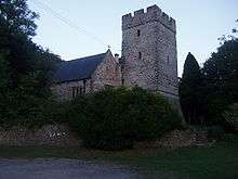
St. Andrews Major

St. Andrew's Major (Welsh: Saint Andras) is a village and parish in the Vale of Glamorgan, between Barry and Cardiff in south-eastern Wales.
The village has a church which is over 600 years old and a primary school. The church is dedicated to St. Andrew, and is in the Benefice of St. Andrews Major and Michaelston-le-Pit. Back in the early 19th century the house just past the Church used to be a coaching inn, but the local Lord of the Manor had it closed down as all of his farm labourers were spending their wages in there and not getting any work done (according to local history). The property is now a private residence. There is now no pub in the village these days
In 1891 the village had a population of 1149 people, although now it is simply a small hamlet with less than 150 residents.
Geography
The surrounding soil of the parish is a strong, brown, dry earth, well adapted for grain of all kinds. The substratum of the whole is limestone. The ground is rather elevated and hilly towards the northern, side of the parish, and flat and level towards the southern side. It is sometimes subject to partial inundation from the overflowing of a small stream, called Dinas Powis brook, which runs through the south-eastern part of the parish towards the south, and empties itself into the Bristol Channel, between the parishes of Cadoxton and Sully, which lie between St. Andrew's and the channel.
The Church
At the east end of the north aisle, parallel with the chancel, is a private chapel, anciently the property and burial-place of a respectable family, named Rowel, long since extinct, and the Bouville family who were owners of a great part of the parish. In the floor of this chapel there is a stone bearing an inscription of the tombs of a couple who had both lived extremely long lives:
Here lyeth the body of John Gibbon James, buried the 14 of August, 1601. And Margaret Mathew, his wife, buried the 8 of January, 1631. He aged ninety-nine, she aged one hundred and twenty-four.
John Wesley is reputed to have preached from the pulpit.
Coordinates: 51°26′08″N 3°14′26″W / 51.43556°N 3.24056°W
