Barry, Vale of Glamorgan
| Barry | |
| Welsh: Y Barri | |
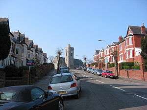 A typical street in Romilly, All Saints Church pictured at the top of the hill. |
|
 Barry |
|
| Population | 51,502 [1] |
|---|---|
| OS grid reference | ST119682 |
| – Cardiff | 9.9 miles (15.9 km) |
| – London | 164.1 miles (264.1 km) |
| Community | Barry |
| Principal area | Vale of Glamorgan |
| Ceremonial county | South Glamorgan |
| Country | Wales |
| Sovereign state | United Kingdom |
| Post town | BARRY |
| Postcode district | CF62–63 |
| Dialling code | 01446 |
| Police | South Wales |
| Fire | South Wales |
| Ambulance | Welsh |
| EU Parliament | Wales |
| UK Parliament | Vale of Glamorgan |
| Welsh Assembly | Vale of Glamorgan |
|
|
Coordinates: 51°24′18″N 3°16′12″W / 51.405°N 3.270°W
Barry (Welsh: Y Barri pronounced [ə ˈbarɪ]) is a town in the Vale of Glamorgan, Wales, on the north coast of the Bristol Channel approximately 7 miles (11 km) south-southwest of Cardiff. Barry is a seaside resort, with attractions including several beaches and the resurrected Barry Island Pleasure Park. According to the 2011 census, the population of Barry was 51,502, making it the fifth largest town in Wales.
Once a small village, Barry has absorbed its larger neighbouring villages of Cadoxton and Barry Island. It grew significantly from the 1880s with the development of Barry Docks, which in 1913 was the largest coal port in the world. The place was possibly named after Saint Baruc.[2] However another explanation is that it comes from the Welsh "bar" meaning a hill or rise. Therefore the Welsh name, Y Barri, means The Hills. The first reference to it being named after St Baruc is from Giraldus Cambriensis (Gerald of Wales).
History
Early history
The area now occupied by Barry has seen human activity in many periods of history. Mesolithic or Middle Stone Age microlith flint tools have been found at Friars Point on Barry Island and near Wenvoe[3] and Neolithic or New Stone Age polished stone axe-heads were discovered in St. Andrews Major.[4] A cinerary urn (pottery urn buried with cremation ashes) was found on Barry Island during excavations of Bronze Age barrows[5][6] and two more were found in a barrow at Cold Knap Point.[7] A large defended enclosure or Iron Age promontory hillfort was located at the Bulwarks at Porthkerry[8] and there was evidence of the existence of an early Iron Age farmstead during construction of Barry College off Colcot Road.[9]

In Roman times farmsteads existed on the site of Barry Castle and Biglis and there were verbal reports of discovery of a cemetery including lead coffins with scallop-shell decoration. Both St. Baruc's Chapel and St. Nicholas Church have re-used Roman bricks and tiles incorpoarated in their building fabric[10] and a Roman villa was discovered in Llandough.[11] In 1980 a Roman building consisting of 22 rooms and cellars in four ranges around a central courtyard was excavated at Glan-y-môr and is believed to be a third-century building associated with naval activity, maybe a supply depot.[12]
The Vikings launched raids in the area and Barry Island was known to be a raider base in 1087.[13] Flat Holm and Steep Holm islands in the Bristol Channel have their name Holm name derived from a Scandinavian word for an island in an estuary. The excavation of the Glan-y-môr site revealed the site had been reused in the 6th and 7th century and also between AD 830 and 950 as a dry stone sub-rectangular building with a turf or thatched roof.[10]
Medieval Barry
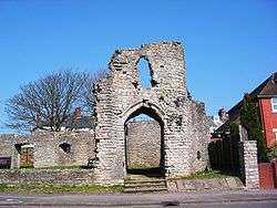

The main feature of the area at this time was the island in the Bristol Channel, separated from the mainland by a tidal estuary. It is described in Giraldus Cambrensis or Gerald of Wales' Itinerarium Cambriae ("Journey through Wales", 1191). He states that Barry derives its name from St. Baruc whose remains are deposited in a chapel on the island. The local noble family who owned the island and the adjoining estates took the name of de Barri from the island.[14]
Following the Norman conquest of England the area was divided into manors with the Barry area split into two large lordships, Penmark and Dinas Powys. Penmark was split into the sub-manors of Fonmon, West Penmark and Barry. Dinas Powys was split into the sub-manors of Cadoxton and Uchelolau (Highlight).[15] The sub-manor of Barry was granted by the de Umfraville family to the de Barri family and the seat of the manor was Barry Castle, located on high ground overlooking the Bristol Channel, a site occupied in Roman times by a native homestead.[16] The castle was a small fortified manor house, built to replace an earlier earthwork. By the late 13th century the castle had two stone buildings on the east and west sides of a courtyard. Early in the 14th century the castle was strengthened by the addition of a large hall and gatehouse on its south side, the ruins of which are all that survive today.[17] By now Barry had grown into a village and port with its own church and watermill but in the 14th century its population was drastically reduced by the Black Death and the consequences of the rebellion of Owain Glyndŵr.[18] It took the population some 300 years to recover and once more hold the title of village, essentially a sparsely populated area with a few scattered farms and much of the land a marsh that a small river flowed through.[19] By 1622 the pattern of fields, where enclosure was almost complete, around Barry village was pretty much as it was to remain until the growth of the modern town. According to the 1673 Hearth-Tax list the parish contained thirteen houses.
Whitehouse Cottage, the oldest existing inhabited house in modern Barry, dates from the late 1500s with the east end of the building added in around 1600. It overlooks the sea at Cold Knap.[20]
Industrial history


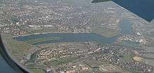
By 1871 the population of Barry was over 100, with 21 buildings, the new estate-owning Romilly family being involved in the buildup of the village but it remained a largely agricultural community.[10][21] It grew when it was developed as a coal port in the 1880s. The coal trade was growing faster than the facilities at Tiger Bay in Cardiff ever could and so a group of colliery owners formed the Barry Railway Company and chose to build the docks at Barry. Work commenced in 1884 and the first dock basin was opened in 1889 to be followed by two other docks and extensive port installations. The Barry Railway brought coal down from the South Wales Valleys to the new docks whose trade grew from one million tons in the first year, to over nine million tons by 1903. The port was crowded with ships and had flourishing ship repair yards, cold stores, flour mills and an ice factory. By 1913, Barry was the largest coal exporting port in the world.
Behind the docks rose the terraced houses of Barry which, with Cadoxton, soon formed a sizeable town. The railways which had played a major part in the development of the dock helped make Barry Island a popular resort. Barry Memorial Hall on Gladstone Road was inaugurated in November 1932, and obtained its name to honour those locals who lost their lives in World War I.[22]
During its industrial peak a number of ships sank off the Barry coast.
Barry Scrapyard
Following the rise of diesel and electric power on the UK railways, the marshalling yards at Barry Docks became the largest repository of steam engines awaiting scrapping in the UK. Dai Woodham owned the Woodham Brothers Scrap yard and he allowed rail preservation organisations to buy back the locomotives at the scrap value allowing around 200 of the 300 locos to be saved for future generations, although during the years of storage many were vandalised or looted by souvenir hunters. When interviewed just before his death, Woodham was reluctant to take full credit for this and pointed out that the town of Barry with its redundant sidings was the major factor in allowing these locos to be saved.
Modern times

Barry is the administrative centre of the Vale of Glamorgan, and home to Barry Town United F.C..
The road from Bonvilston was originally the B4266, as only Pontypridd Road within the town still is, and the road from Highlight Park right through the Vale to Bridgend was the B4265, as beyond Cardiff International Airport it still is. Since the 1970s, parts of these roads are numbered A4226, with the result that the A4226 radiates from Weycock Cross roundabout in three directions.
The town is often associated with Woodham Brothers scrapyard, a business that helped over 200 steam locomotives survive into preservation.
Although still a port, Barry is more of a manufacturing town and as a service centre for the Vale of Glamorgan. Barry Docks and the adjoining industrial area form the largest employment centre in the town. The docks, whose road links were dramatically improved with the opening of the Docks Link Road in 1981, now have direct road access with the M4 motorway. The docks can handle vessels up to 23,000 tonnes and the first-class tidal position close to the deep-water channel of the Severn Estuary, allows for scheduled sailings. With its transit sheds, warehouses and open storage, the docks are equipped to handle bulk cargoes but with the scrapping of their former electric cranes, ships’ own derricks have to be used or cranes hired in by ABP as required. Two roll on/roll off berths are available and have been used by routes to Ireland and West Africa. As at January 2016, Intermodal raifreight traffic is being operated from No.2 Dock. With a new presence on the Mole in No.1 Dock and the provision of a concrete slipway from it, leisure rowing and dinghy sailing is available (2016).
The town has a town council which is controlled by the Labour Party.
The majority of industrial firms are located in the dock area. The largest are the chemical producing concerns such as Cabot Carbon and Dow Corning who not long ago completed the development of the largest silicones plant in Europe. Other main employers in Barry Docks are Jewson Builders' Merchants, Western Welding and Engineering, Bumnelly, and Associated British Ports Holdings who, since 1982 have run the docks as successors to the British Transport Docks Board.
To the west of Barry is Porthkerry Park. This is a large area of open space, with woodlands, streams, and access to a pebbly beach. In the park is the former Barry Railway Company viaduct with 13 arched spans standing 110 ft high. Following the closure of the Vale of Glamorgan line to passengers between Barry and Bridgend in 1964, it was reopened on 10th June 2005 and for most of its 19 miles, provides a scenic view and link to Llantwit Major and beyond to Bridgend.
Barry Island

The Barry Island peninsula was an island until the 1880s when it was linked to the mainland as the town of Barry expanded. This was partly due to the opening of Barry Dock by the Barry Railway Company. Established by David Davies, the docks now link up the gap which used to form Barry Island.
There is a railway station to access the island at Barry Docks, there is also a heritage railway station which houses refurbished steam passenger trains. The railway is open to the public and holds events involving a large steam engine replica of Thomas the Tank Engine.
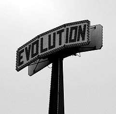
Barry Island is now known for its beach and Barry Island Pleasure Park. From 1966, the island was home to a Butlins Holiday camp, which was closed in 1987 and taken over by Majestic Holidays who renamed it Barry Island Resort. Between Butlins' closure and Majestic's reopening the camp was used as for filming scenes in the "Shangri-La" holiday camp from the Doctor Who serial Delta and the Bannermen. The camp closed in 1996 after Majestic had a disagreement with the local council, who refused an entertainments licence unless work was carried out to improve the now 30-year-old site. It was redeveloped for housing between 1997–2003 with the remaining two camp buildings and outdoor pool demolished in early 2005.

The preserved Vale of Glamorgan Railway runs on Barry Island. From the late 1960s onwards, Woodhams Yard, Barry was home to hundreds of British Rail steam locomotives that were due to be scrapped. Many were sold to preservation societies. By the late 1980s, two-thirds had been saved for preservation.
The BBC sitcom Gavin & Stacey was filmed in many areas of Barry and Barry Island.
Politics and administration
UK parliamentary constituency
From the 1536 Act of Union, Glamorgan was represented in parliament by one member, elected by the freeholders in the county.[23] In 1885, the constituency was split into three with the creation of East Glamorganshire, Mid Glamorganshire and South Glamorganshire. The Representation of the People Act 1918 created the Llandaff and Barry constituency.[24] Sir William Cope (Conservative) won the 1918 general election. Labour regained the seat at the 1929 general election when Charles Ellis Lloyd was returned but two years later lost the seat to the Conservatives' Patrick Munro.

After Munro's death in 1942 Cyril Lakin won the by-election for the Conservatives. Arwyn Lynn Ungoed-Thomas (Labour) won the seat at the 1945 general election. The Llandaff and Barry constituency was abolished by the Representation of the People Act 1948.[25] and replaced by the Barry parliamentary constituency. This seat was first contested in the United Kingdom general election, 1950 when Dorothy Rees (Labour) was elected. She lost the seat to Sir Herbert Raymond Gower (Conservative) at the 1951 general election. He held the seat until its abolition in 1983.[26]
It was replaced by the Vale of Glamorgan constituency which Sir Herbert Raymond Gower (Conservative) won at the 1983 general election. He remained as MP until his death in 1989. At the subsequent by-election the seat was won by John Smith (Labour). At the 1992 general election Walter Sweeney (Conservative) won it by only 19 votes. That made it the most marginal seat in Britain.[27] John Smith won it back at the 1997 general election. In the 2010 General election there was a 6.1% swing from labour to conservative. This has now handed the seat to Alun Cairns a (Conservative) MP.[28]
Welsh Assembly

Barry is part of the Vale of Glamorgan Assembly constituency[29] and part of the South Wales Central Assembly region.[30] Jane Hutt has been the Vale of Glamorgan Assembly member since the inception of the Welsh Assembly.
Local councils
Barry was incorporated as a municipal borough by Royal Charter in September 1939. The Borough was the successor to Barry and Cadoxton Local Board (1888–1894) and Barry Urban District Council (1894–1939). The area covered by the borough comprised Barry, Cadoxton-juxta-Barry, Merthyr Dyfan and parts of Penmark, Porthkerry and Sully. In 1974, it was abolished and its functions taken over by the Vale of Glamorgan District Council and South Glamorgan County Council.[31]
The local council, Barry Town Council, is the largest town council in Wales. It has given Olympic silver medalist David Davies freedom of the town, the first freedom granted since 1958. The mayor is Stuart Egan who represents Butrills Ward. The town council is controlled by Labour.
The local unitary authority, created in 1995, is the Vale of Glamorgan Council which has its administrative headquarters in Barry. There are 23 wards electing 47 councillors which comprise Baruc (Barry) (2 councillors), Buttrills (Barry) (2), Cadoc (Barry) (3), Castleland (Barry) (2), Court (Barry) (2), Gibbonsdown (Barry) (2), Dyfan (Barry) (2), Illtyd (Barry) (3), Cowbridge (3), Dinas Powys (4), Llandough (1), Llandow Ewenny (1), Llantwit Major (4), Cornerswell (Penarth) (2), Plymouth (Penarth) (2), Stanwell (Penarth) (2), St. Augustines (Penarth) (2), Peterston-super-Ely (1), Rhoose (2), St Athan (1), St Brides Major (1), Sully (2), Wenvoe (1).
Districts

- Barry Island
- Barry Waterfront
- Buttrills
- Cadoxton
- Colcot
- Coldbrook
- Cwm Talwg
- Gibbonsdown
- Gladstone
- Highlight Park
- Holton
- Jenner Park
- Merthyr Dyfan
- Palmerstown
- Pencoedtre
- Romilly
Climate
As with the rest of the British Isles and Wales, Barry experiences a maritime climate with cool summers and mild winters, and often high winds. It is amongst the sunnier of Welsh locations, due to its southerly and coastal position. The nearest official weather observation station is at Rhoose Airport, about 3 miles west of the town centre.
| Climate data for Rhoose 65m asl, 1971–2000 | |||||||||||||
|---|---|---|---|---|---|---|---|---|---|---|---|---|---|
| Month | Jan | Feb | Mar | Apr | May | Jun | Jul | Aug | Sep | Oct | Nov | Dec | Year |
| Average high °C (°F) | 7.3 (45.1) |
7.5 (45.5) |
9.7 (49.5) |
12.0 (53.6) |
15.5 (59.9) |
18.2 (64.8) |
20.5 (68.9) |
20.4 (68.7) |
17.7 (63.9) |
14.0 (57.2) |
10.4 (50.7) |
8.3 (46.9) |
13.5 (56.3) |
| Average low °C (°F) | 2.3 (36.1) |
2.0 (35.6) |
3.4 (38.1) |
4.5 (40.1) |
7.4 (45.3) |
10.1 (50.2) |
12.4 (54.3) |
12.4 (54.3) |
10.6 (51.1) |
8.0 (46.4) |
4.8 (40.6) |
3.3 (37.9) |
6.8 (44.2) |
| Average precipitation mm (inches) | 95 (3.74) |
69 (2.72) |
77 (3.03) |
60 (2.36) |
60 (2.36) |
64 (2.52) |
63 (2.48) |
83 (3.27) |
98 (3.86) |
106 (4.17) |
107 (4.21) |
103 (4.06) |
983 (38.7) |
| Mean monthly sunshine hours | 55 | 74 | 113 | 174 | 212 | 208 | 220 | 207 | 150 | 103 | 74 | 49 | 1,639 |
| Source: MeteoFrance[32] | |||||||||||||
The arts

- Series 3 – 5 of "Being Human" (2010 on) was filmed in and around Barry Island, with much of the storyline referring to the town as "infested" with werewolves and vampires.
- The 2011 film Submarine, although set in Swansea was mostly filmed in Barry.
- Barry hosted the National Eisteddfod of Wales in 1920 and 1968.[33][34]
- The Doctor Who serial Delta and the Bannermen was set and filmed in Barry.
- Several scenes of the Doctor Who episodes "The Empty Child" and "The Doctor Dances" were filmed at the Vale of Glamorgan Railway sites at Plymouth Road and Barry Island in January 2005,[35]
- Gavin & Stacey is partly set and filmed in and around Barry.
- Art Central, a modern art gallery run by the local council, was created in the Town Hall as part of the library redevelopment in 2006.[36][37][38]
- There is a Community Arts Centre being developed Named 'Canolfan Porthceri Centre', this is being developed within the building and grounds of Porthkerry Road Methodist Church, due to the Methodist Church Moving to new premises within the Waterfront Development.
Schools
Secondary schools

Barry has four secondary schools. Since 1993, Bryn Hafren and Barry Comprehensive Schools have worked together to provide the co-educational Barry Sixth Form.[39]
- Barry Comprehensive School – boys 11–16, mixed 16–18
- Bryn Hafren Comprehensive School – girls 11–16, mixed 16–18
- St Richard Gwyn Catholic High School, Barry – mixed 11–16
- Ysgol Gyfun Bro Morgannwg – Welsh-medium school, mixed 11–18
Primary schools
Primary education (5–11) in Barry is provided by a number of community, Welsh-language, and faith-based schools spread throughout the town.[40]
- All Saints Church in Wales Primary School
- Barry Island Primary School
- Cadoxton Primary School
- Colcot Primary School
- Gladstone Primary School
- High Street Primary School
- Holton Primary School
- Jenner Park Primary School
- Oakfield Primary School
- Palmerston Primary School
- Romilly Primary School
- St Helen's RC Infants School (5–7)
- St Helens's RC Junior School (7–11)
- Ysgol Gwaun y Nant – Welsh-medium school
- Ysgol Sant Baruc – Welsh-medium school
- Ysgol Sant Curig – Welsh-medium school
- Ysgol Nant Talwg – Welsh-medium school
Sport
- Barry Town F.C.
- Barry RFC
- Sea View RFC
- Barry 40
Transport

The main forms of public transport in the town are bus and rail. Barry is served by Cardiff Bus which operates services to Llantwit Major, Penarth, Cardiff International Airport and Cardiff City Centre as well as operating town circular services. Barry's King's Square bus station is located on King's Square in the town centre. The A4050 road connects Barry to Culverhouse Cross Interchange and the rest of west Cardiff.
There are four railway stations in the town: Barry, Barry Docks, Barry Island and Cadoxton. These are operated and served by Arriva Trains Wales and are on the Valley Lines network, a commuter rail network focused on Cardiff. Services operate westbound to Bridgend via Llantwit Major and Rhoose Cardiff International Airport, and eastbound to Cardiff Queen Street via Dinas Powys, Cardiff Grangetown and Cardiff Central. The latter service can continue to either Merthyr Tydfil, Pontypridd and/or Aberdare.
Barry is located less than 3 miles (4 kilometres) east of Cardiff International Airport.
Nearby places
- Barry Island, a peninsula forming part of the town of Barry
- The Bendricks, a rocky beach by the harbour
- Sully Island, a small tidal islet a mile east of the harbour
- Sully, a village east of the town
Notable people
- See Category:People from Barry, Vale of Glamorgan
References
- ↑ "Parish population 2011". Retrieved 9 April 2015.
- ↑ http://www.barrytowncouncil.gov.uk/history.php?Action=History
- ↑ G Dowell (1971). Archaeology in Wales Volume 11 pp. 10–11. Council for British Archaeology.
- ↑ H. N. Savory (1948–50). Axes of Pembrokeshire Stone from Glamorganshire Volume XIII pp. 245–6. Board of Celtic Studies.
- ↑ J Romilly Allen (1873). A description of some cairns on Barry Island, Glamorganshire Volume 28 (1873) pp. 189–91. Archaeologia Cambrensis.
- ↑ "Archaeologia Cambrensis Volume 28 (1873) – Table of Contents". ARCHway. Retrieved 21 April 2007.
- ↑ Aileen Fox (1936). An account of John Storrie's excavations on Barry Island in 1894-5 Volume LXIX (1936) pp.12–28. Cardiff Naturalists Society.
- ↑ Jeffrey L Davies. "An excavation at the Bulwarks, Porthkerry, Glamorgan 1968 Vol 122 (1973) pp. 85–98". Archaeologia Cambrensis. Retrieved 21 April 2007.
- ↑ H.J. Thomas and G. Davies (1965). Archaeology in Wales Volume 5 pp.25. Council for British Archaeology.
- 1 2 3 Donald Moore (1984). Barry The Centenary Book. The Barry Centenary Book Committee Limited. ISBN 0-9509738-0-7.
- ↑ H.S. Owen John (1978–79). Llandough: a late Iron Age farmstead, Romano-British villa and medieval monastic grange G-GAT Annual Report pp. 27–38. Glamorgan-Gwent Archaeological Trust.
- ↑ G Dowell and E.M. Evans (1980–81). Glan-y-môr, Cold Knap, Barry G-GAT Annual Report pp. 1–3. Glamorgan–Gwent Archaeological Trust.
- ↑ "Times Past". Barry Town Council. Archived from the original on 21 July 2006. Retrieved 10 April 2007.
- ↑ "Itinerary of Baldwin in Wales by Giraldus Cambrensis". Project Gutenberg. Retrieved 21 April 2007.
- ↑ John Stuart Corbett (1925). Glamorgan, Papers and Notes on the Lordship And Its Members... with a Memoir. Cardiff Naturalists Society.
- ↑ Manorial map of Barry Glamorgan, III (part ii), p.120. RCAM (Wales) Royal Commission on Ancient Monuments (Wales).
- ↑ "Barry Castle". Castles of Wales. Archived from the original on 27 April 2007. Retrieved 10 April 2007.
- ↑ Glamorgan, III (part ii), pp.215–43. RCAM (Wales) Royal Commission on Ancient Monuments (Wales).
- ↑ "A General History of Barry Town". Barry Town Crier. Archived from the original on 4 May 2007. Retrieved 10 April 2007.
- ↑ "Whitehouse Cottage, Cold Knap Way, the Knap, Barry". British Listed Buildings. Retrieved 10 April 2016.
- ↑ "Population Statistics for Barry". Genuki (UK & Ireland Genealogy). Retrieved 22 May 2007.
- ↑ Gaffney, Angela (1998). Aftermath: Remembering the Great War in Wales. University of Chicago Press. p. 39. ISBN 978-0-7083-1494-4.
- ↑ "Glamorgan Record Office Register of Electors" (PDF). Glamorgan Archives. Archived (PDF) from the original on 10 June 2007. Retrieved 29 April 2007.
- ↑ "List of former United Kingdom Parliamentary constituencies". Glosk.com. Retrieved 29 April 2007.
- ↑ "The House of Commons Constituencies beginning with "L"". Leigh Rayment's Peerage Page. Retrieved 29 April 2007.
- ↑ "The House of Commons Constituencies beginning with "B"". Leigh Rayment's Peerage Page. Retrieved 29 April 2007.
- ↑ "Vale of Glamorgan". BBC (British Broadcasting Corporation). Retrieved 29 April 2007.
- ↑ "BBC NEWS – Election 2010 – Vale of Glamorgan". BBC News.
- ↑ "Vale of Glamorgan". University of Keele. Retrieved 29 April 2007.
- ↑ "South Wales Central". University of Keele. Retrieved 29 April 2007.
- ↑ "Glamorgan Record Office Borough of Barry records". Archive Network Wales. Retrieved 10 April 2007.
- ↑ "Rhoose 1971-00 averages". MetroFrance. Retrieved 27 October 2011.
- ↑ "National Eisteddfod of Wales Locations since 1880". Eisteddfod Genedlaethol Cymru. Retrieved 22 May 2007.
- ↑ "British Pathe National Eisteddfod". British Pathe. Archived from the original on 30 September 2007. Retrieved 22 May 2007.
- ↑ as were the end-fight scenes from "The Christmas Invasion" in August 2005. "The Empty Child – location guide". BBC. Retrieved 10 April 2007.
- ↑ "Square will be fit for a King", Barry & District News, 3 April 2003. Retrieved 15 November 2013.
- ↑ Rebecca Lord (18 November 2016) "Art Central Gallery celebrates tenth anniversary with diverse exhibition", Barry & District News. Retrieved 19 November 2016.
- ↑ Art Central, Vale of Glamorgan Council.
- ↑ "Barry Comprehensive School, 1971–98". Archived from the original on 7 July 2011. Retrieved 9 July 2011.
- ↑ "Primary Schools". Vale of Glamorgan Council. Retrieved 9 July 2011.
External links
| Wikimedia Commons has media related to Barry, Vale of Glamorgan. |
| Wikivoyage has a travel guide for Barry. |
| Wikisource has the text of the 1911 Encyclopædia Britannica article Barry. |
- Vale of Glamorgan Council
- Barry coastguard team
- Vale of Glamorgan Railway website.
- Port of Barry
- www.geograph.co.uk : photos of Barry and surrounding area
