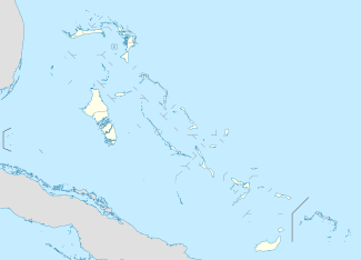
Grand Bahama
| Native name: <span class="nickname" ">Grand Bahamian | |
|---|---|
|
Western and central Grand Bahama seen from space, looking southwest | |
 Grand Bahama | |
| Geography | |
| Location | Atlantic Ocean |
| Coordinates | 26°39′N 78°19′W / 26.650°N 78.317°W |
| Archipelago | Bahamas |
| Area | 1,373 km2 (530 sq mi) |
| Highest elevation | 40 ft (12 m) |
| Administration | |
| Largest settlement | Freeport |
| Demographics | |
| Population | 51,756[1] (2010) |
| Pop. density | 37.70 /km2 (97.64 /sq mi) |
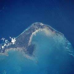
Grand Bahama is the northernmost of the islands of the Bahamas, and the closest major island to the United States, lying 86 kilometres (53 mi) off of Palm Beach, Florida. It is the fourth largest island in the Bahamas island chain of approximately 700 islands and 2,400 cays. The island is approximately 153 kilometres (95 mi) long west to east and 24 kilometres (15 mi) at its widest point north to south. Administratively, the island consists of the Freeport Bonded Area and the districts of East Grand Bahama and West Grand Bahama.
History
Early Spanish contact
The Spanish gave the island the name Gran Bajamar, meaning "Great Shallows", and what the eventual name of the Bahamas islands as a whole is derived from. However, the Lucayan (pre-Columbian) name for the island was Bahama.[2] Grand Bahama's existence for almost two centuries was largely governed by the nature of these "great shallows" - the coral reefs surrounding the island were treacherous, and repelled its Spanish claimants (who largely left it alone apart from infrequent en route stops by ships for provisions) while attracting pirates, who would lure ships onto the reefs where they would run aground and be plundered. The Spaniards took little interest in the island after enslaving the native Lucayan inhabitants.[3]
British rule
The islands were claimed by Great Britain in 1670. Piracy continued to thrive for at least half a century after the British takeover, though the problem was eventually brought under control.
Grand Bahama was to remain relatively quiet until the mid-nineteenth century, with only around 200-400 regular inhabitants in the capital, West End. In 1834, the towns of Pinder’s Point, Russell Town and Williams Town were established by former Bahamian slaves after the abolition of slavery in the British empire. The island remained under-developed until a brief boom in economic activity during the American Civil War, when it was a center for blockade runners smuggling goods (mostly weaponry, sugar and cotton) to the Confederacy. A second brief smuggling boom occurred during the years of prohibition in the USA.[4]
Hawksbill Creek Agreement era
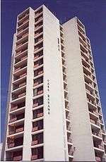
By the middle of the 20th century, Grand Bahama's population numbered around 500 and the island was one of the least developed of the Bahamas' islands. However the island finally gained a stable source of income when in 1955 a Virginian financier named Wallace Groves began redevelopment with the Bahamian government to build the city of Freeport under the Hawksbill Creek Agreement and create the Grand Bahama Port Authority. Soon after, the ambitious Edward St. George, with the financial help of Sir Jack Hayward, took the company to new frontiers. Seeing the success of Cuba as a tourist destination for wealthy Americans, St. George was eager to develop Grand Bahama in a similar vein. The city grew rapidly, with St. George adding a harbour, an airport soon after the city was founded, and the tourist center of Port Lucaya in 1962. Grand Bahama became the second most populous island in the Bahamas (over 50,000 in 2004).[5]
Economy
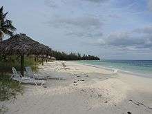
Tourism is the mainstay of the island's economy. The resort area at Port Lucaya and visits by cruise ships provide the bulk of this activity. Grand Bahama's tourism sector is complemented by the BORCO oil bunkering facility owned by Buckeye,[6] the South Riding Point oil storage and transhipment terminal owned by Statoil,[7] and a transshipment/container port partly owned by Hong Kong conglomerate Hutchison Whampoa and the Grand Bahama Port Authority. There are also quarrying operations on the island and a large shipyard.
There are two airports on the island: Grand Bahama International Airport in Freeport, and West End Airport in West End. Grand Bahama International Airport is the larger of the two, and West End Airport is open sporadically for private aircraft only.
Administrative regions
Grand Bahama is divided into three districts and seven town areas for administrative purposes. Each district is run by a Chief Councilor, and each town area or township is run by a Chairperson. As of 1996 Grand Bahama has three districts.[8]
Elections are held every 5 years in Grand Bahama. The two principal parties are the Progressive Liberal Party and the Free National Movement.
Main settlements
- Freeport is the main city of Grand Bahama, it holds the commercial ship harbour and the main airport.
- Lucaya is a tourist destination on the island, with beaches and hotels.
- West End is the capital of Grand Bahama. It first achieved notoriety as a rum-running port during the Prohibition.
- In the 1950s it became home to the Jack Tar marina and club. However, over the years the marina fell into disrepair, and the whole city of West End was of little economic import to Grand Bahama. In 2001, the resort was reopened as Old Bahama Bay Resort & Yacht Harbour.[9]
- Eight Mile Rock is the largest settlement in Grand Bahama and all of The Bahamas. It stretches out 8 miles of rocky shore, hence its name. It is home to many of recent NBA and WNBA players such as Buddy Hield and Jonquel Jones
- McLeans Town is the easternmost settlement and a 30-minute ferry ride from the northernmost settlement of the neighbor island of Abaco.
References
- ↑ "PRELIMINARY POPULATION AND HOUSING COUNT BY ISLAND AND SUPERVISORY DISTRICT, ALL BAHAMAS: CENSUS 2010" (PDF). Bahamas Department of Statistics.
- ↑ Julius Granberry and Gary S. Vescelius. (2004) Languages of the Pre-Columbian Antilles. The University of Alabama Press. ISBN 0-8173-5123-X p. 83
- ↑ The earliest settlers, the Siboney Indians http://www.grandbahamavacations.com/ about-the-island/history-of-grand-bahama-island/ It is believed they had an advanced political and social structure, and lived in well-organized cities.
- ↑ Great Britain claimed The Islands of The Bahamas in 1670, after British colonists left Bermuda for the island of Eleuthera http://www.grandbahamavacations.com/about-the-island/history-of-grand-bahama-island/ when history finally caught up with it again.
- ↑ In 1955, the second most populated city of The Bahamas was little more than a pine forest http://www.grandbahamavacations.com/about-the-island/history-of-grand-bahama-island/ Over 30 years later, the result is a community completely tailored to the getaway tourist, a premeditated paradise offering almost every kind of vacation activity imaginable.
- ↑ Buckeye Partners, L.P. "BORCO". Retrieved 2013-02-21.
- ↑ Statoil ASA. "Bahamas - South Riding Point". Retrieved 2013-02-21.
- ↑ http://www.bahamas.gov.bs/bahamasweb2/home.nsf/vContentW/A5FB7665F3E4341306256F0000763055
- ↑ Hotel Online Report
External links
| Wikimedia Commons has media related to Grand Bahama. |
| Wikivoyage has a travel guide for Grand Bahama. |
- Official Tourism Site of The Islands of the Bahamas
- Official Site of the Grand Bahama Island Tourism Board
- BASRA - Bahamas Air-Sea Rescue Association
- Grand Bahama Power Company