Grande Prairie
| Grande Prairie | |||
|---|---|---|---|
| City | |||
| City of Grande Prairie | |||
|
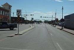
100 Street, looking south from 100 Avenue | |||
| |||
| Nickname(s): Swan City[1] | |||
 Grande Prairie Location of Grande Prairie in Alberta | |||
| Coordinates: 55°10′15″N 118°47′41″W / 55.17083°N 118.79472°WCoordinates: 55°10′15″N 118°47′41″W / 55.17083°N 118.79472°W | |||
| Country | Canada | ||
| Province | Alberta | ||
| Region | Northern Alberta | ||
| Census division | 19 | ||
| Incorporated[2] | |||
| • Village | April 30, 1914 | ||
| • Town | March 15, 1919 | ||
| • City | January 1, 1958 | ||
| Government[3] | |||
| • Mayor | Bill Given | ||
| • Governing body |
Grande Prairie City Council
| ||
| • Manager | Greg Scerbak | ||
| • MP | Chris Warkentin | ||
| • MLA | Everett McDonald, Wayne Drysdale | ||
| Area (2011)[4][5] | |||
| • City | 72.80 km2 (28.11 sq mi) | ||
| Elevation[6] | 650 m (2,130 ft) | ||
| Population (2011)[4] | |||
| • City | 55,032 | ||
| • Density | 755.9/km2 (1,958/sq mi) | ||
| • Urban | 54,913 | ||
| • Municipal census (2015) | 68,556[7] | ||
| Time zone | MST (UTC−7) | ||
| • Summer (DST) | MDT (UTC−6) | ||
| Postal code span | T8V to T8X | ||
| Area code(s) | +1-780, +1-587 | ||
| Highways |
Highway 43 Highway 40 | ||
| Waterways | Wapiti River Bear River (Bear Creek) | ||
| Website | Official website | ||

Grande Prairie is a city in northwest Alberta, Canada within the southern portion of an area known as Peace River Country. It is located at the intersection of Highway 43 (part of the CANAMEX Corridor) and Highway 40 (the Bighorn Highway), approximately 456 km (283 mi) northwest of Edmonton. The city is surrounded by the County of Grande Prairie No. 1.
Grande Prairie is the seventh-largest city in Alberta with a population 55,032 recorded by the 2011 Census,[4] and was one of Canada's fastest growing cities between 2001 and 2006.[8]
The city adopted the trumpeter swan as an official symbol due to its proximity to the migration route and summer nesting grounds of this bird. For that reason, Grande Prairie is sometimes nicknamed the "Swan City". The dinosaur has emerged as an unofficial symbol of the city due to paleontology discoveries in the areas north and west of the Grande Prairie.
History
Grande Prairie was named for the large prairie which lies to the north, east, and west of it. In the 18th century, the prairie was occupied by bands of the Beaver First Nation who began trading with the North West Company at Dunvegan in the early 19th century. The earliest recorded reference to the prairie was by trader Samuel Black in 1824. In 1880, a Hudson's Bay Company post called La Grand Prairie was established by George Kennedy 15 miles (24 km) northwest of the present city. In the late 19th century, the prairie was settled by Cree and Iroquois from around Jasper and Lac Ste. Anne. When 17 townships were surveyed for homesteading in 1909, a land rush soon followed, with many settlers arriving over the Edson Trail. In 1910, the Grande Prairie Townsite was sub-divided. By 1912, it included a bank, hotel, post office, and land office, making it a district metropolis. In 1916, it became the terminus of the Edmonton, Dunvegan and British Columbia Railway from Edmonton.
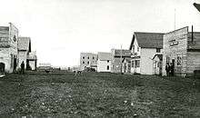
The Edson Trail from Edson to Grande Prairie was opened in 1911 as a means for settlers to reach the Grande Prairie area. It was basically nothing more than a tract of clear cut bush and forest, and thus was a very difficult route for many settlers, especially during wet weather. Because of this, large scale settlement came late compared to other major farming regions further south in Canada. Grande Prairie was incorporated as a village by the Province of Alberta in 1914. It was not until the arrival of the railway in 1916 that farmland quickly expanded as waves of settlers came into the Peace region. This drove up Grande Prairie's population past the 1,000 mark, allowing it to incorporate as a town on March 27, 1919. A local recession in the 1920s caused a temporary depopulation of Grande Prairie. But the population rebounded afterwards by the 1930s, by which time the population had reached 1,464. Settlement continued unabated even into the 1930s during the Dust Bowl era because the Peace Region was able to escape the severe drought conditions that plagued the Canadian Prairies further south at the time.[9]
The Second World War saw the US and Canadian military establish Grande Prairie as a part of the Northwest Staging Route for the construction of the Alaska Highway from Dawson Creek to Alaska. Although Dawson Creek was chosen as the major starting point of the construction of the Alaska highway, Grande Prairie was a major stopover point for military aircraft during the war, and benefited economically from this.
Although Grande Prairie was well located in the southern edge of the Peace Country, it was competing with the towns of Peace River and Dawson Creek for the title of the most important centre of commerce and agriculture in the region until the late 1950s, when its population growth began to outstrip these towns as oil and natural gas exploration was underway in the Peace Region, especially since the first major discovery of oil further south in Leduc near Edmonton in 1947 and the construction of a large pulp mill in the early 1970s.
The construction and paving of Highway 43 (originally sections of Highways 2, 34, and 43 from the BC border to the Yellowhead Highway just west of Edmonton) in 1956 cut down on the travel time by road significantly, further enhancing Grande Prairie's accessibility and economic status. The town was incorporated as a city in 1958. At that time, its population was approximately 7,600.
The opening of the Procter & Gamble kraft pulp mill in 1972 and the discovery of the Elmworth deep basin gas field spurred an economic boom. Grande Prairie's population went from just over 12,000 in the early 1970s to over 24,000 by the time the oil boom went bust in 1981.
A tornado struck the downtown area and east side of Grande Prairie on July 8, 2004. Although the tornado was considered a very weak one (F0-F1 on the Fujita scale) and the weather was not severe at the time, it was still strong enough to incur damage to houses and flip vehicles over. There were no casualties or fatalities.[10]
Geography

Grande Prairie is located just north of the 55th parallel north, and is 465 km (289 mi) northwest of Edmonton, lying at an elevation of 669 metres (2,195 ft) above sea level. The city is surrounded by farmland to the north, east, and west. To the south, it is mostly a vast boreal forest with aspen, tamarack, lodgepole pine, jack pine, and black spruce extending well into the foothills of the Canadian Rockies south and southwest of the city.
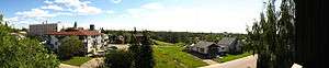
Bear Creek goes through the city from the northwest to the south end and is a tributary of the Wapiti River to the south. The Bear Creek Reservoir is the small body of water by Grande Prairie Regional College in the northwest part of the city, and is ringed by marshy wetland. The terrain immediately surrounding Grande Prairie is largely flat to gently rolling, but rises gradually to hilly terrain closer to the foothills to the south and southwest. On clear days, some peaks in the Rockies are visible to the southwest from Grande Prairie.
The city lies on the southern edge of aspen parkland, which is a transitional biome between boreal forest and prairie. The Peace Country contains the northernmost area of aspen parkland in North America. However, much of the aspen parkland in the region has long since been destroyed by extensive farming and oil/gas drilling activity.
Climate
Grande Prairie has a northern continental climate typical of northwestern Alberta and northeastern BC, classified as humid continental (Dfb), bordering closely on a subarctic climate (Dfc) under the Köppen climate classification. Winters are generally very cold with some mild spells. Summers are often fairly cool to pleasantly warm in the daytime, but nights can be cool despite the long summer days typical for its latitude. Hot days over 30 °C (86 °F) are rare, occurring on average, only two to three days a year, which is not unexpected this far north. Winter conditions can vary tremendously from year to year. Winters have been known to be mild enough to produce "brown Christmas" conditions, where little or no snow may fall until after Christmas due to unusually mild early winter conditions.
The average January temperature is −13.6 °C (7.5 °F), while the average July temperature is 16.2 °C (61.2 °F). However, temperatures as low as −52.2 °C (−62 °F) and as high as 35.6 °C (96 °F)[11] have been recorded; the extreme humidex and wind chill readings are 40.8 and −63.0 °C (105 and −81 °F), respectively. The city receives 445 millimetres (17.5 in) of precipitation annually, including 322 mm of rain and 154 cm of snow (12.7 in rain, 61 inches of snow). Snowfall amounts, however, vary greatly from year to year. Being fairly close to the foothills of the Canadian Rockies, it can get quite windy in Grande Prairie, especially in the spring and fall. Chinooks may occur in and bring winter thaws to the Grande Prairie area. Grande Prairie has 314 days with measureable sunshine per year on average, and just above 2,200 hours of bright sunshine or about 46.1% of possible sunshine, ranging from a low of 31.2% in November to a high of 59.1% in July.[12]
Summers can bring thunderstorms, although they are not as frequent nor as severe as those further south in Central Alberta. Rainfall can vary from year to year, but the Peace Region is noted for never having experienced truly severe drought conditions more typical of Southern Alberta and neighbouring Saskatchewan. Tornadoes are rare but not unheard of in the Peace Region and, as noted above, a weak tornado actually struck the core of the city in 2004.
| Climate data for Grande Prairie Airport (1981−2010) | |||||||||||||
|---|---|---|---|---|---|---|---|---|---|---|---|---|---|
| Month | Jan | Feb | Mar | Apr | May | Jun | Jul | Aug | Sep | Oct | Nov | Dec | Year |
| Record high humidex | 14.5 | 11.1 | 15.6 | 28.6 | 30.8 | 33.6 | 40.8 | 36.6 | 34.7 | 27.1 | 17.2 | 12.1 | 40.8 |
| Record high °C (°F) | 15.2 (59.4) |
11.8 (53.2) |
16.1 (61) |
29.2 (84.6) |
31.3 (88.3) |
33.3 (91.9) |
35.6 (96.1) |
34.5 (94.1) |
31.1 (88) |
28.9 (84) |
22.2 (72) |
13.3 (55.9) |
35.6 (96.1) |
| Average high °C (°F) | −8.0 (17.6) |
−4.8 (23.4) |
0.6 (33.1) |
10.1 (50.2) |
16.8 (62.2) |
20.5 (68.9) |
22.6 (72.7) |
21.7 (71.1) |
16.6 (61.9) |
9.4 (48.9) |
−1.8 (28.8) |
−6.0 (21.2) |
8.1 (46.6) |
| Daily mean °C (°F) | −13.6 (7.5) |
−10.6 (12.9) |
−4.9 (23.2) |
4.1 (39.4) |
10.2 (50.4) |
14.3 (57.7) |
16.2 (61.2) |
15.1 (59.2) |
10.2 (50.4) |
3.6 (38.5) |
−6.6 (20.1) |
−11.3 (11.7) |
2.2 (36) |
| Average low °C (°F) | −19.0 (−2.2) |
−16.4 (2.5) |
−10.3 (13.5) |
−2.0 (28.4) |
3.6 (38.5) |
8.1 (46.6) |
9.8 (49.6) |
8.3 (46.9) |
3.8 (38.8) |
−2.1 (28.2) |
−11.4 (11.5) |
−16.7 (1.9) |
−3.7 (25.3) |
| Record low °C (°F) | −52.2 (−62) |
−48.3 (−54.9) |
−42.8 (−45) |
−35.6 (−32.1) |
−8.7 (16.3) |
−2.2 (28) |
0.6 (33.1) |
−2.8 (27) |
−10.6 (12.9) |
−31.7 (−25.1) |
−40.6 (−41.1) |
−47.2 (−53) |
−52.2 (−62) |
| Record low wind chill | −63.0 | −55.0 | −53.1 | −46.7 | −16.1 | −4.3 | 0.0 | −3.2 | −15.3 | −33.9 | −56.1 | −56.3 | −63.0 |
| Average precipitation mm (inches) | 29.9 (1.177) |
16.4 (0.646) |
16.9 (0.665) |
19.8 (0.78) |
41.0 (1.614) |
75.9 (2.988) |
76.1 (2.996) |
55.8 (2.197) |
43.0 (1.693) |
26.0 (1.024) |
25.4 (1) |
18.9 (0.744) |
445.1 (17.524) |
| Average rainfall mm (inches) | 2.4 (0.094) |
0.8 (0.031) |
1.4 (0.055) |
10.4 (0.409) |
38.1 (1.5) |
75.9 (2.988) |
76.1 (2.996) |
55.7 (2.193) |
41.3 (1.626) |
15.4 (0.606) |
4.2 (0.165) |
0.7 (0.028) |
322.4 (12.693) |
| Average snowfall cm (inches) | 35.0 (13.78) |
20.8 (8.19) |
20.3 (7.99) |
11.0 (4.33) |
3.4 (1.34) |
0.0 (0) |
0.0 (0) |
0.1 (0.04) |
1.7 (0.67) |
12.0 (4.72) |
26.5 (10.43) |
23.6 (9.29) |
154.3 (60.75) |
| Average precipitation days (≥ 0.2 mm) | 11.7 | 8.5 | 9.0 | 7.6 | 10.5 | 13.2 | 13.3 | 11.8 | 11.7 | 10.7 | 11.3 | 9.1 | 128.4 |
| Average rainy days (≥ 0.2 mm) | 1.9 | 0.81 | 1.6 | 4.8 | 10.0 | 13.2 | 13.4 | 11.8 | 11.5 | 7.7 | 2.8 | 0.81 | 80.4 |
| Average snowy days (≥ 0.2 cm) | 10.8 | 8.4 | 8.0 | 3.8 | 1.1 | 0.0 | 0.0 | 0.04 | 0.63 | 4.0 | 9.3 | 8.5 | 54.5 |
| Mean monthly sunshine hours | 77.8 | 106.2 | 172.1 | 231.0 | 276.0 | 295.2 | 307.7 | 272.4 | 172.5 | 134.5 | 78.9 | 73.5 | 2,197.7 |
| Percent possible sunshine | 32.1 | 39.1 | 47.0 | 54.6 | 55.1 | 56.9 | 59.1 | 58.7 | 45.0 | 41.3 | 31.2 | 32.7 | 46.1 |
| Source: Environment Canada[11][12] | |||||||||||||
Demographics
| Federal census population history | ||
|---|---|---|
| Year | Pop. | ±% |
| 1916 | 337 | — |
| 1921 | 1,061 | +214.8% |
| 1926 | 917 | −13.6% |
| 1931 | 1,464 | +59.7% |
| 1936 | 1,478 | +1.0% |
| 1941 | 1,724 | +16.6% |
| 1946 | 2,267 | +31.5% |
| 1951 | 2,664 | +17.5% |
| 1956 | 6,302 | +136.6% |
| 1961 | 8,352 | +32.5% |
| 1966 | 11,417 | +36.7% |
| 1971 | 13,079 | +14.6% |
| 1976 | 17,626 | +34.8% |
| 1981 | 24,263 | +37.7% |
| 1986 | 26,471 | +9.1% |
| 1991 | 28,271 | +6.8% |
| 1996 | 31,140 | +10.1% |
| 2001 | 36,983 | +18.8% |
| 2006 | 47,076 | +27.3% |
| 2011 | 55,032 | +16.9% |
| Source: Statistics Canada [13][14][15][16][17][18][19][20][21][22][23] [4][24][25][26][27][28][29][30][31] | ||
The population of the City of Grande Prairie according to its 2015 municipal census is 68,556,[7] a 36.5% change from its 2007 municipal census population of 50,227.[32]
In the 2011 Census, the City of Grande Prairie had a population of 55,032 living in 21,180 of its 22,979 total dwellings, a 16.8% change from its 2006 adjusted population of 47,107. With a land area of 72.8 km2 (28.1 sq mi), it had a population density of 755.9/km2 (1,957.9/sq mi) in 2011.[4]
In 2006, according to the Canada 2006 Census, Grande Prairie had a population of 47,076 living in 17,941 dwellings, a 27.3% increase from 2001. The city has a land area of 61.08 km2 (23.58 sq mi) and a population density of 770.7/km2 (1,996/sq mi).[33]
As recorded in the Canada 2001 Census, the median age was 29.7 (Alberta median age was 35.0), and the Median Total Income for age 15 and up was $25,414.[34]
In the 2011 National Household Survey, 10% percent of residents identified themselves as Aboriginal, 6% of residents identified themselves as visible minorities.[35] The largest visible minority group were Filipinos, which accounted for 34% of total visible minorities.[35] Almost 90 percent of residents identified English as their first language at the time of the 2006 census, while almost three percent identified French and two percent identified German as their first language learned. The next most common languages were Polish, Tagalog, Cree, and Ukrainian.[36] More than 70 percent of residents identified themselves as Christian at the time of the 2001 census while almost 28 percent indicated they had no religious affiliation. For specific denominations Statistics Canada counted 9,255 Roman Catholics (about 25 percent of the population) and 3,955 members of the United Church of Canada (about 10 percent), as well as 2,165 Anglicans and 2,020 Lutherans (about 5 percent each).[37] Less numerous denominations included 880 Baptists and 790 residents identifying as Pentecostal (about 2 percent each).
Economy
Grande Prairie possesses a diversified economy. Major industries include oil and gas, agriculture, forestry, and food services.
Agriculture was the first economic mainstay of Grande Prairie since settlement began in the early 20th Century. It remains part of the local economy today. A variety of crops such as barley, wheat, canola, and oats are grown in the area. Livestock such as cattle and buffalo (bison) are also raised in the area. Despite being north of 55°N, the climate is mild enough to allow for farming on a large scale to prosper. Longer daylight hours during the summer at this latitude aid in crop production. The Peace Country is the northernmost major farming region in North America. Land within the region is still being cleared for new farmland.
Although some oil and gas drilling has been ongoing in the area since the 1950s, oil and gas exploration did not begin to occur on a large scale until the late 1970s. It was in the mid-1970s that the Elmworth gas field was discovered and developed, causing the city to grow rapidly until the last oil boom ended in 1981.
Forestry is a major part of Grande Prairie's economy, for large tracts of forest lie to the south in the foothills of the Canadian Rockies. The Weyerhaeuser Canada kraft pulp mill, opened in 1972 by Procter & Gamble, is one of Grande Prairie's largest employers. Canfor runs a sawmill and lumber yard operation on the west side of the city. The Ainsworth Oriented Strand Board plant opened in late 1995.
Grande Prairie serves as the economic and transportation hub for a trading area of nearly 250,000 people. Grande Prairie is also on the CANAMEX trade route linking Canada, the United States, and Mexico.
Arts and culture
Live music can be found in several downtown bars and intermittently at all-ages locations such as Tito's Restaurant and the GP Curling Club. Summer-long music festivals have been organized by community-minded individuals and charitable organizations. Grande Prairie has a surprisingly wide range of local music genres including country (such as Tenille,[38] Brad Sims,[39] and more), Reggae (Tasman Jude [40]), Metal (Arrival Of Autumn [41]), folk, rock and much more
Cultural venues include the Bowes Family Crystal Centre (a concert hall and hockey rink — the local AJHL team, the Grande Prairie Storm, plays there), the Grande Prairie Museum, the Art Gallery of Grande Prairie, which has recently re-opened, The Rabbit Hole bookstore, and Second Street Theatre. Grande Prairie is also home to a professional musical theatre company, "Broadway Live Broadway", which engages equity actors and performs on the college campus.
The Reel Shorts Film Festival is a five-day international festival of short films in Grande Prairie that takes place at Grande Prairie Live Theatre's Second Street Theatre in early May.[42][43]
Sports and recreation
The city has a number of parks and golf courses including the large Muskoseepi Park in the Bear Creek Valley and the Dunes Golf Course south of the city. Muskoseepi Park has excellent bike trails extending nearly the entire length of Bear Creek within the city. Muskoseepi Park also has an outdoor swimming pool and a pavilion with a cafeteria and an outdoor pond which converts into a skating rink in the winter. Crystal Lake in the northeast part of the city also has parkland, preserved wetlands (great for birdwatching), and walking/bike paths around its entire circumference.
Grande Prairie has three 18-hole golf courses nearby including The Dunes Golf and Winter Club, the Bear Creek Golf Club, and the Grande Prairie Golf and Country Club), and a fourth, Grovedale Golf Course, approximately 20 km (12 mi) to the southwest of Grande Prairie.[44]
Cross-country skiing and snowmobiling are popular activities during the winter in the Grande Prairie area. There is a local ski hill called Nitehawk located south of the city on the south bank of the Wapiti River. Aside from skiing, Nitehawk also has the only North American natural luge track certified for international events and over the summer months freestyle ski jumpers can practice using the Northern Extreme water ramp facility. It is also active in luge as a naturally refrigerated venue, hosting the FIL World Luge Natural Track Championships in 2007.
The foothills south of Grande Prairie and around Grande Cache are popular year-round for hiking in the summer and for snowmobiling and other winter sports in the winter. Kakwa Wildland Park on the Alberta-BC border, about 180 kilometres (110 miles) south of the city, is a beautiful and mountainous natural area and is known for a beautiful waterfall called Kakwa Falls.
The Eastlink Centre, briefly known as the Multiplex, is an indoor fitness facility that has an indoor pool, splash park, lazy river, and surf simulator. It also includes a weight room and fitness classes, a daycare service and a multi-use basketball court among other amenities and classes. The Eastlink Centre is located in southwest Grande Prairie and connects St. Joseph High School, the Grande Prairie Gymnastics Centre, and the Coca-Cola Centre.[45] In March 2012 the Eastlink Centre received an award for its exceptional accessibility features.[46]
The Leisure Centre, formerly the Rec-Plex, is located in northwest Grande Prairie near the Bear Creek Reservoir. In December 2011, after the Eastlink Centre opened, the majority of the Leisure Centre was closed, with plans to reopen in the second half of 2013.[47] Currently the swimming pool and gym remain closed, but the indoor soccer pitch is open.
| Club | League | Sport | Venue | Established | Championships |
|---|---|---|---|---|---|
| Grande Prairie Storm | Ice Hockey | Canada Games Arena | |||
| Grande Prairie Kings | Ice Hockey | Coca-Cola Centre | |||
| Grande Prairie Athletics | Ice Hockey | Coca-Cola Centre |
Infrastructure
Transportation
- Air
Grande Prairie Airport is located in the west end of the city and serves the region with daily scheduled flights to Calgary and Edmonton. Two airlines, Air Canada Express and WestJet, offer service to Grande Prairie Airport. The airport has seen growth in both passenger and aircraft traffic in recent years. The Grande Prairie Airport was developed in the 1930s at the present site. In 1941 in support of the war effort, the facility was expanded from a grass strip for utilization by the Royal Canadian and US Air Force. In 1950 the airport came under the authority of the Federal Government until February 1, 1997 at which time it was transferred to the City of Grande Prairie.[48] The terminal, built in 1981, was renovated in 2009 making it twice its original size. Forthcoming expansions include an update to the parking system and expansion of the runway.[49]
- City public transit
Grande Prairie Transit is a small public transit system with modern buses and a route system integrated throughout the city.
- Charter bus
Greyhound Canada offers scheduled bus service to Grande Prairie from Edmonton and other communities in northwestern Alberta and northeastern British Columbia and Yukon.
- Highways and roads
Highway 43 is the main highway through the city providing eventual connection to British Columbia to the west and Edmotnon to the southeast. Highway 43 meets Highway 2 a few kilometres north of the city at an intersection known locally as Four Mile Corner, then continues south into the city. It travels through the city via a northwest bypass and exits the city on the west end near the airport.
The stretch of Highway 2 extending north from Grande Prairie to Four Mile Corner and west to the Alberta/BC border was renumbered to Highway 43 in the late 1990s to link with the rest of Highway 43 from Four Mile Corner to the Yellowhead Highway just west of Edmonton. This explains why newer maps no longer show that stretch west and a few km north of the city as Highway 2. The renumbering was also partly due to Highway 43 now being a part of the CANAMEX trade route and also that it is being widened to a four-lane divided highway along its entire length. Highway 40 is the primary access road into Grande Prairie from the south.
Construction of a new Highway 43X bypass to go around the northwest side of the city from Four Mile Corner to Highway 43 just west of the airport has begun as of August 2007[50] ("Four Mile Corner" is not an actual settlement - it is an intersection so-named because it is four miles (6 km) north of the intersection of Clairmont Road (100th Street) and Richmond Avenue (100th Avenue)). The construction is in two phases, with the first phase under construction and the second currently in the design stage. The first phase extends west to Range Road 63 (116 Street within city limits), while the second phase runs west from Range Road 63 south to Highway 43 west of the airport. The future bypass is intended to replace the current one. The current bypass, which was built in the late 1960s, is no longer functioning well as one due to high traffic volumes and new intersections. The rapid population growth of Grande Prairie is contributing to such a high increase in vehicle traffic that traffic jams are now common during peak hours.
Grande Prairie sees many vacationers heading to the Alaska Highway by road during the summer because Highway 43 leads towards Dawson Creek, BC, which is the "Mile 0" of the Alaska Highway.
- Rail
The City of Grande Prairie has rail freight service provided by Canadian National (CN). The rail line s connected to CN's main line near Hinton.
- Street layout
Grande Prairie's streets are usually numbered rather than named, with the exception of some major roadways. In fact, the street numbering system is based on the Grid plan.
The downtown core is centred at 100 Street (Clairmont Road) and 100 Avenue (Richmond Avenue). Streets run north-south, while avenues run east-west. The letter "A" is sometimes used if a street lies between two streets but doesn't correspond to the street numbering grid. For example, 100A Avenue would lie between 100 and 101 Avenues.
Houses and buildings with odd numbers are on the east side of a street or the south side of an avenue. Dropping the last two digits of a house number tells you what two streets or avenues the house lies between, for example 9835 101 Avenue is between 98 Street and 99 Street, and 11610 91 Street is between 116 Avenue and 117 Avenue.
An unusual element of the city's street layout is the presence of the "Canfor Hauling Road" that parallels 108 Street in the southwest, before cutting across the south side of the city. Closed to public traffic, the road allows industrial trucks to traverse that part of the city with minimal interference from standard traffic.
Education
Secondary
Three school districts operate secondary schools within Grande Prairie.[51]
The Grande Prairie Public School District (GPPSD)[52] operates 15 secondary schools including Grande Prairie Christian School and the Bridge Network Outreach,[53] a school specially geared for students who cannot or will not attend the traditional high school education system due to various challenges or a need for alternative education.
Grande Prairie and District Catholic Schools (GP&DCS) operates ten schools within Grande Prairie, including the St. John Bosco Outreach.[54]
The Peace Wapiti School Division No. 76 (PWSD) operates two schools that serve students of the surrounding County of Grande Prairie No. 1.[55]
Aside from the two outreach schools that provide alternative curriculum for high school students, Grande Prairie's four high schools are Grande Prairie Composite High School (GPPSD), St. Joseph’s Catholic High School (GP&DCS), Charles Spencer High School (GPPSD) and Peace Wapiti Academy (PWSD).
Post-secondary
Grande Prairie Regional College (GPRC), established in 1966, is the primary post-secondary institution in the city and offers degrees in a few programs. The present college campus was built in 1974 and expanded later in the early 1990s. Its unique architecture was originally designed by the renowned Canadian architect Douglas Cardinal. The college has been administered by Don Gnatiuk since January 2007.
In 1995, the city hosted the Canada Games. The event was televised nationally on CBC Television. Hundreds of performers competed in the events and the city gained status and recognition as a result. The city played host to the 2010 Arctic Winter Games from March 6–13, 2010.
Media
References
- ↑ "History of Grande Prairie". City of Grande Prairie. Retrieved 2012-06-09.
- ↑ "Location and History Profile: City of Grande Prairie" (PDF). Alberta Municipal Affairs. June 17, 2016. p. 57. Retrieved June 18, 2016.
- ↑ "Municipal Officials Search". Alberta Municipal Affairs. November 18, 2016. Retrieved November 21, 2016.
- 1 2 3 4 5 "Population and dwelling counts, for Canada, provinces and territories, and census subdivisions (municipalities), 2011 and 2006 censuses". Statistics Canada. 2012-02-08. Retrieved 2012-02-08.
- ↑ "Population and dwelling counts, for Canada, provinces and territories, and population centres, 2011 and 2006 censuses (Alberta)". Statistics Canada. 2013-01-30. Retrieved 2013-03-17.
- ↑ "Alberta Private Sewage Systems 2009 Standard of Practice Handbook: Appendix A.3 Alberta Design Data (A.3.A. Alberta Climate Design Data by Town)" (PDF) (PDF). Safety Codes Council. January 2012. pp. 212–215 (PDF pages 226–229). Retrieved October 8, 2013.
- 1 2 "2015 Municipal Affairs Population List" (PDF). Alberta Municipal Affairs. ISBN 978-1-4601-2630-1. Retrieved February 27, 2016.
- ↑ "Population and dwelling counts, for Canada and census subdivisions (municipalities) with 5,000-plus population, 2006 and 2001 censuses - 100% data". Statistics Canada. 2010-01-06. Retrieved 2012-10-28.
- ↑ David W. Leonard, Chronology of Grande Prairie to 1951
- ↑ "Alberta cleaning up from tornado". CBC News. July 9, 2004. Retrieved January 31, 2012.
- 1 2 "Grande Prairie A". Canadian Climate Normals 1981−2010. Environment Canada. Retrieved May 14, 2014.
- 1 2 "Grande Prairie A". Canadian Climate Normals 1981−2010. Environment Canada. Retrieved October 4, 2013.
- ↑ "Table I: Population of Manitoba, Saskatchewan, and Alberta by Districts, Townships, Cities, Towns, and Incorporated Villages in 1916, 1911, 1906, and 1901". Census of Prairie Provinces, 1916. Population and Agriculture. Ottawa: Government of Canada. 1918. pp. 77–140.
- ↑ "Table 8: Population by districts and sub-districts according to the Redistribution Act of 1914 and the amending act of 1915, compared for the census years 1921, 1911 and 1901". Census of Canada, 1921. Ottawa: Government of Canada. 1922. pp. 169–215.
- ↑ "Table 7: Population of cities, towns and villages for the province of Alberta in census years 1901-26, as classed in 1926". Census of Prairie Provinces, 1926. Census of Alberta, 1926. Ottawa: Government of Canada. 1927. pp. 565–567.
- ↑ "Table 12: Population of Canada by provinces, counties or census divisions and subdivisions, 1871-1931". Census of Canada, 1931. Ottawa: Government of Canada. 1932. pp. 98–102.
- ↑ "Table 4: Population in incorporated cities, towns and villages, 1901-1936". Census of the Prairie Provinces, 1936. Volume I: Population and Agriculture. Ottawa: Dominion Bureau of Statistics. 1938. pp. 833–836.
- ↑ "Table 10: Population by census subdivisions, 1871–1941". Eighth Census of Canada, 1941. Volume II: Population by Local Subdivisions. Ottawa: Dominion Bureau of Statistics. 1944. pp. 134–141.
- ↑ "Table 6: Population by census subdivisions, 1926-1946". Census of the Prairie Provinces, 1946. Volume I: Population. Ottawa: Dominion Bureau of Statistics. 1949. pp. 401–414.
- ↑ "Table 6: Population by census subdivisions, 1871–1951". Ninth Census of Canada, 1951. Volume I: Population, General Characteristics. Ottawa: Dominion Bureau of Statistics. 1953. p. 6.73–6.83.
- ↑ "Table 6: Population by sex, for census subdivisions, 1956 and 1951". Census of Canada, 1956. Population, Counties and Subdivisions. Ottawa: Dominion Bureau of Statistics. 1957. p. 6.50–6.53.
- ↑ "Table 6: Population by census subdivisions, 1901–1961". 1961 Census of Canada. Series 1.1: Historical, 1901–1961. Volume I: Population. Ottawa: Dominion Bureau of Statistics. 1963. p. 6.77-6.83.
- ↑ "Population by specified age groups and sex, for census subdivisions, 1966". Census of Canada, 1966. Population, Specified Age Groups and Sex for Counties and Census Subdivisions, 1966. Ottawa: Dominion Bureau of Statistics. 1968. p. 6.50–6.53.
- ↑ "Table 2: Population of Census Subdivisions, 1921–1971". 1971 Census of Canada. Volume I: Population, Census Subdivisions (Historical). Ottawa: Statistics Canada. 1973. p. 2.102-2.111.
- ↑ "Table 3: Population for census divisions and subdivisions, 1971 and 1976". 1976 Census of Canada. Census Divisions and Subdivisions, Western Provinces and the Territories. Volume I: Population, Geographic Distributions. Ottawa: Statistics Canada. 1977. p. 3.40–3.43.
- ↑ "Table 4: Population and Total Occupied Dwellings, for Census Divisions and Subdivisions, 1976 and 1981". 1981 Census of Canada. Volume II: Provincial series, Population, Geographic distributions (Alberta). Ottawa: Statistics Canada. 1982. p. 4.1–4.10. ISBN 0-660-51095-2.
- ↑ "Table 2: Census Divisions and Subdivisions – Population and Occupied Private Dwellings, 1981 and 1986". Census Canada 1986. Population and Dwelling Counts – Provinces and Territories (Alberta). Ottawa: Statistics Canada. 1987. p. 2.1–2.10. ISBN 0-660-53463-0.
- ↑ "Table 2: Population and Dwelling Counts, for Census Divisions and Census Subdivisions, 1986 and 1991 – 100% Data". 91 Census. Population and Dwelling Counts – Census Divisions and Census Subdivisions. Ottawa: Statistics Canada. 1992. pp. 100–108. ISBN 0-660-57115-3.
- ↑ "Table 10: Population and Dwelling Counts, for Census Divisions, Census Subdivisions (Municipalities) and Designated Places, 1991 and 1996 Censuses – 100% Data". 96 Census. A National Overview – Population and Dwelling Counts. Ottawa: Statistics Canada. 1997. pp. 136–146. ISBN 0-660-59283-5.
- ↑ "Population and Dwelling Counts, for Canada, Provinces and Territories, and Census Divisions, 2001 and 1996 Censuses - 100% Data (Alberta)". Statistics Canada. Retrieved 2012-04-01.
- ↑ "Population and dwelling counts, for Canada, provinces and territories, and census subdivisions (municipalities), 2006 and 2001 censuses - 100% data (Alberta)". Statistics Canada. 2010-01-06. Retrieved 2012-04-01.
- ↑ "Alberta 2009 Official Population List" (PDF). Alberta Municipal Affairs. September 15, 2009. Retrieved September 12, 2010.
- ↑ Statistics Canada. "Canada 2006 Census: Grande Prairie - Community Profile". Retrieved 2007-06-14.
- ↑ Grande Prairie (City) 2006 community profile - Statistics Canada. 2006 Community Profiles. Released March 13, 2007. Last modified: 2007-03-13. Statistics Canada Catalogue no. 92-591-XWE.
- 1 2 "NHS Profile, Grande Prairie, CY, Alberta, 2011 &ndash Aboriginal peoples". Statistics Canada. January 8, 2014. Retrieved January 24, 2014.
- ↑ "Grande Prairie". Detailed Mother Tongue (186), Knowledge of Official Languages (5), Age Groups (17A) and Sex (3) for the Population of Canada, Provinces, Territories, Census Metropolitan Areas and Census Agglomerations, 2001 and 2006 Censuses - 20% Sample Data. Statistics Canada. 20 November 2007. Retrieved 2008-02-06.
- ↑ "Grande Prairie". Religion (95A), Age Groups (7A) and Sex (3) for Population, for Canada, Provinces, Territories, Census Metropolitan Areas and Census Agglomerations, 1991 and 2001 Censuses - 20% Sample Data. Statistics Canada. 1 March 2007. Retrieved 2008-02-06.
- ↑ http://www.cbc.ca/live/qa-tenille-on-her-ccma-humanitarian-award.html
- ↑ http://www.dailyheraldtribune.com/2014/08/28/local-country-artist-eyes-the-next-level
- ↑ http://www.trinidadexpress.com/featured-news/Harts-Tasman-Jude-flies-the-Caribbean-flag-in-Canada-237163241.html
- ↑ http://www.dailyheraldtribune.com/2014/11/06/arrival-of-autumn-hits-the-stage-next-week
- ↑ "About Reel Shorts". Retrieved 27 October 2012.
- ↑ Henson, Jeff (28 March 2012). "Final Preparations Underway For Reel Shorts Film Festival". HQGrandePrairie.com. Retrieved 28 October 2012.
- ↑ "Grande Prairie – Golf". Discover the Peace Country Visitors Guide. Retrieved January 24, 2014.
- ↑ "About the Facility". Retrieved 22 February 2013.
- ↑ "Eastlink Centre Honoured For Accessibility Features" (PDF). Retrieved 22 February 2013.
- ↑ "The Leisure Centre". Retrieved 22 February 2013.
- ↑ "History of the Grande Prairie Airport". Retrieved 1 August 2015.
- ↑ "Grande Prairie Airport". Retrieved 1 August 2015.
- ↑ Alberta Infrastructure and Transportation. "Construction starts on long-awaited Grande Prairie bypass". Retrieved 2007-09-04.
- ↑ City of Grande Prairie. "Education & Health Services". Retrieved 2015-03-15.
- ↑ http://www.gppsd.ab.ca/Pages/default.aspx Grande Prairie Public School District
- ↑ Grande Prairie Public School District. "Schools". Retrieved 2015-03-15.
- ↑ Grande Prairie and District Catholic Schools. "Our Schools". Retrieved 2015-03-15.
- ↑ Peace Wapiti School Division. "School Contact Information". Retrieved 2015-03-15.
External links
![]() Media related to Grande Prairie at Wikimedia Commons
Media related to Grande Prairie at Wikimedia Commons
 |
Dawson Creek Hythe |
Sexsmith Clairmont |
Peace River Grimshaw |
|
| Beaverlodge Wembley |
|
Bezanson Debolt Crooked Creek | ||
| ||||
| | ||||
| Grande Cache | Valleyview |
| Subdivisions | |
|---|---|
| Communities | |
| Cities and urban service areas | |
| |