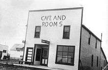
Wembley, Alberta
| Wembley | |
|---|---|
| Town | |
| Town of Wembley | |
 Wembley | |
| Coordinates: 55°09′26″N 119°08′21″W / 55.15722°N 119.13917°WCoordinates: 55°09′26″N 119°08′21″W / 55.15722°N 119.13917°W | |
| Country |
|
| Province |
|
| Region | Northern Alberta |
| Census division | 19 |
| Municipal district | County of Grande Prairie No. 1 |
| Incorporated[1] | |
| • Village | January 3, 1928 |
| • Town | August 1, 1980 |
| Government | |
| • Mayor | Chris Turnmire |
| • Governing body | Wembley Town Council |
| Area (2011)[2] | |
| • Total | 4.54 km2 (1.75 sq mi) |
| Elevation[3] | 724 m (2,375 ft) |
| Population (2011)[2] | |
| • Total | 1,383 |
| • Density | 304.8/km2 (789/sq mi) |
| Time zone | MST (UTC-7) |
| Highways |
Highway 43 Highway 724 |
| Waterways |
Wapiti River Saskatoon Lake |
| Website | Official website |

Wembley is a town in northern Alberta, Canada. It is located approximately 23 km (14 mi) west of Grande Prairie at the junction of Highway 43 and Highway 724. A resident of Wembley is known as a "Wemblian", or "Wembleyite".
Land around Wembley was surveyed for homesteads in 1909, settlers beginning to arrive in 1910. The railroad survey was completed from Grande Prairie to Pouce Coupe in 1916 and the townsite of Wembley was surveyed in 1923. The railway arrived in 1924.[4]
The present town-site is four and a half miles south of the original hamlet of Lake Saskatoon and when the railway arrived in 1924 many buildings were hauled over the four and one half miles of snow-covered trails from Lake Saskatoon to their new foundations in Wembley.[4] The name Wembley was chosen by the Lake Saskatoon Board of Trade at the time of the British Empire Exposition at Wembley in England.[5]
The post office opened in November 1924, the first postmaster being RB Sinclair. [5]
Wembley reached village status January 3, 1928[4] and town status August 1, 1980.
Demographics
The Town of Wembley's 2012 municipal census counted a population of 1,410.[6]
In the 2011 Census, the Town of Wembley had a population of 1,383 living in 514 of its 542 total dwellings, a -4.2% change from its 2006 population of 1,443. With a land area of 4.54 km2 (1.75 sq mi), it had a population density of 304.6/km2 (789.0/sq mi) in 2011.[2]
According to the 2006 census, Wembley has a:
- population of 1,443 living in 504 dwellings, a 3.6% decrease from 2001
- land area of 3.63 km2 (1.40 sq mi)
- and a population density of 397.9/km2 (1,031/sq mi).[7]
See also
References
- ↑ "Location and History Profile: Town of Wembley" (PDF). Alberta Municipal Affairs. October 7, 2016. p. 730. Retrieved October 16, 2016.
- 1 2 3 "Population and dwelling counts, for Canada, provinces and territories, and census subdivisions (municipalities), 2011 and 2006 censuses (Alberta)". Statistics Canada. 2012-02-08. Retrieved 2012-02-08.
- ↑ "Alberta Private Sewage Systems 2009 Standard of Practice Handbook: Appendix A.3 Alberta Design Data (A.3.A. Alberta Climate Design Data by Town)" (PDF) (PDF). Safety Codes Council. January 2012. pp. 212–215 (PDF pages 226–229). Retrieved October 9, 2013.
- 1 2 3 Along the Wapiti. RR 2, Grande Prairie Alberta: Wapiti River Historical Society. 1981. p. 315. ISBN 092056402X.
- 1 2 Place Names of Alberta. 2500 University Drive N.W., Calgary Alberta, T2N 1N4: University of Calgary Press. 1996. p. 226. ISBN 1-895176-59-X.
- ↑ "Minutes October 9/12". Town of Wembley. Retrieved 2012-11-14.
- ↑ Statistics Canada. "Canada 2006 Census: Wembley - Community Profile". Retrieved 2007-06-13.
External links
 |
Hythe | Rycroft | Sexsmith |  |
| Beaverlodge | |
Grande Prairie | ||
| ||||
| | ||||
| Valleyview | Grande Cache |